My month in Rwanda is coming to an end. Beautiful riding and new friendships. I enjoy Kigali’s bars and cafes with views across the many hills.


But Nairobi is calling.
I want to use the back route and explore Western Uganda, avoiding the main highway. I take leave and have around six days to get back home; covering around 1500km.
To be honest, I didn’t plan much. I just wanted to float.
How it ended up going:

Want to catch up on how I got to Rwanda? Here are the earlier episodes:
- Nairobi to Lake Kivu (3.5 day ride) – article here
- Overnight random to Gisenyi/Goma – article here
- Lake Kivu & Ngungwe Forest & Rusizi border ride – article here
Now a solo return to Nairobi – using the scenic route!
Day 31: Leaving Kigali


That was fast. Or maybe I have just figured out the border procedure by now.
Remember to keep left – you’re back in Uganda now!

By the time I arrive in Kabale, it’s raining. The mountains North of Kabale are covered in thick clouds. I put on the rain gear and ride up North navigating the twisties carefully.

Quick photo stop at the arguably most important statue in East Africa. It gets hot again!

The road branching off left at Ntungamo towards Fort Portal does not look very inviting. It’s narrower and a bit pot-hole-ish and cloud towards Rwenzori Mountains are increasing. I’m torn. The whole point is adventure. Remembering the thousand rumble strips on the main highway and violent drivers, I turn left.
I spot some crater lakes on Maps and note it’s 79km to go. A little more than an hour without photo stops. I hit the road.

It never works without photo stops. And rain gear stops.
At some point I get to a roundabout. There’s a left and a right turn, but no straight. There is a Shell petrol station. The first one for a month, as there’s no Shell in Rwanda. I get excited for a minute. V-Power! Civilization!
Then it dawns on me that there should not be a roundabout on my 79km. And no T-Junction. Something is off. I pull out my phone and realize I didn’t press Start on Maps, and missed a right turn. I’m 30 rainy km off in the wrong direction. And how is it 3pm already?

Great. But there is a road up North which I decide to follow.
Until.

Yes, I can continue straight. Through 30km hilly offroad on a rainy day. Or not. I decide to backtrack to the junction I missed.

It’s 4pm now. And from here it gets PRETTY!!


At Ishaka the road from Mbarara joins us from the right. The whole area has very sensible tarmac and very little traffic.


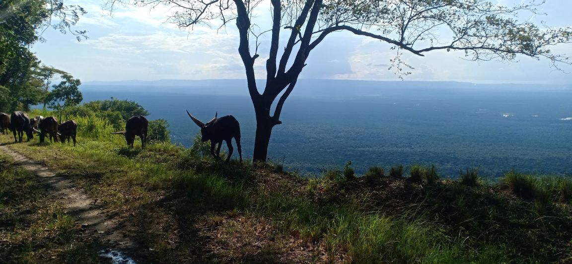
I pass a bunch of crater lakes, each worth a visit and picnic. Then I pass some viewpoints and ride down into empty vast Savannah.


Queen Elizabeth National Park! A Ugandan biker had recommended Kazinga Camp but they are booked out. I find Tembo Lodge on Maps and ride in.


Even a welcoming (!?) hippo! I am given a sensible rate for room and dinner, and decide to spend the night here. But not before exploring the rough road into the National Park with the remaining sunlight.


It’s beautiful sunset riding, but sadly I get to the park gate within minutes. “Bikes are generally not allowed, but exceptions can be made.” Understandably, this is not an option at night…
The team at Tembo has three vegetarian dinner options. It’s yummy but the ten thousand lake flies make me flee to my room very fast after dinner.
Day 32: Rwenzori Mountain Range and Fort Portal
Tourism day! 114km to Fort Portal – all along the Rwenzori Mountains, maybe stealing glances at the glaciers and peaks above 5,000m.
If yesterday’s scenery and empty roads are anything to go by, today will be beautiful!


In Kasese town I get into a misunderstanding at the Total petrol station. I have to ride and get cash from an AMT, as my VISA card is not accepted. The attendant follows me closely on a boda so I don’t escape with the 5 litres of petrol.


It’s all very beautiful scenery and peaceful riding. I filter through Booking.com and pass by the recommended The Dutchess to check out the rooms and vybe. There’s a room with a shared bathroom within my budget, and I bump into the manager who gives me some tips to explore the area in the afternoon.
He’s not as enthusiastic about me riding to Ntoroko, a fishing village at Lake Albert, and mentions the UG-DRC border being more volatile and less hospitable due to smuggling activities. What looks like a cute peninsula along the lake according to him is an overgrown area, with no café or restaurant and is not a place to make friends – if at all I want to go there, I could ride to the UWA (the KWS equivalent) bandas, take a photo and return without talking to anyone to avoid trouble!
I’m of course tickled to do it anyways, but then he raises another idea: A hidden escarpment, with an offroad ride through some mountains to hot springs.
Now that sounds like a sensible afternoon!
I cannot wait to offload the luggage and head out!


Quickly leaving Fort Portal behind heading westwards

In the hostel there was a mention of an escarpment. But in no way did I expect to find this:


What heaven! It gets better with each corner. The tarmac is washed out in some spots by the rain, but it’s 99% great.


The valley is very beautiful too. Soon I’ll have to decide if I turn right towards Lake Albert or go straight to the Hot Springs.

Hot springs it is. Before long, the “old road” branches to the left. A chance to explore some off-road? I’ll take it.


There are some houses and farms. I stop to greet a boda who tells me I shouldn’t bother with the route. It’s steep. He and his passenger both fold their arms indicating a 45% gradient. I tell him I want to try it. He eyes my tires and says “Okay, but be careful.” But of course, yes!


It takes me a good hour for the 15kms over the Buranga Pass, mostly because I take a hundred photos in all angles. The map is thoroughly confusing. I can see the tarmac road directly below me but I’m at least 400m above it! How on earth will I get down? Just how steep will that squiggly road be?


It’s getting late, so I get to practice some of the cornering techniques Grace and her team showed me… and before long I get to the tarmac near the Hot Springs.


There’s a small river somewhere along this green space, it’s the border to DRC. In fact, at some point my phone roams on DRC network and adjusts the time backwards by an hour – confusion much!

I stop at the junction to the old road to buy some water and catch up with the bodas. My guy is also there and nods in acknowledgement. I now think he hasn’t been to that other side in a while.


The sunset across the valley is just the killer!


Usually you wait for the road to clear to take pictures. This place is deserted. So I wait for some minutes just to get some action on the cam!


Day 33: Fort Portal to Kampala
I don’t know what to expect. A Ugandan biker had suggested that I go via Hoima instead of taking the direct road. “The Government is constructing the road”. This would add 100km to my route to 400km total. I want to maximize the time in Kampala with my friend and her kids.
The first 30km are BEAUTIFUL! Smooth tarmac through tea plantations. Then it gets a little rough, but nothing too bad with the right playlist (Thank you, nani!)
Just around 100km into my day, I find there’s not much tarmac left around the potholes. You can imagine what cars and trucks do if they find crater-like potholes on their side of the road and there’s “only” a motorbike on the oncoming lane.

My plan to arrive in Kampala for lunch is out of reach, as I’m averaging 40/50 only.
And it gets worse as I get closer to construction. Or rather, the road was graded in anticipation for construction. It’s many kilometers of gravel with dust.


Finally, I pull up at the petrol station at Mityana. I’m covered in dust. The water I drink tastes dusty. The bike has a dust layer – which just looks horrible on a red shiny bike! My first attempt at a non-earth coloured bike – I might be too lazy for this in the long-run… I try to clean the helmet and visor without scratching it.
A white guy chats me up, who is caging and stayed in the same hostel in Fort Portal. The Shell staff can’t agree whether the road continues as bad or gets better from here.
It turns out to be better from here onwards and I reach Kampala by 3pm.


The roads in Western Uganda were fairly empty, much safer than the main highway through Masaka. Now it’s just a quick 20km dash on the Northern Bypass to my friend’s place. An overspeeding SUV overtakes me closely in my line while I overtake a slow truck. Completely and unnecessarily putting me at risk. There’s something about Ugandan roads that takes some adjusting.
My friend welcomes me warmly and we catch up on life over dinner! Steamed Matooke and G-Nut Sauce!


Day 35: Back to Kenya
How close to Nairobi can I get? It’s 650km!
I leave Kampala early with plans to have breakfast in Jinja and by miracle reach Nakuru today. Same route as five weeks ago!

After fuelling in Mukono, I head out Eastwards towards the forest. The roads are empty, and aside from some slow moving trucks I’m making good progress.


In Jinja, I want to try a local hipster looking breakfast joint I had scouted online (The Hangout Jinja). They unfortunately don’t allow me to park inside the compound and I don’t feel like parking on the road with my luggage strapped on the bike. I find my way to Java instead where the askari waves me to park next to his chair at the main door.
Around 10am I head out from Jinja with plans to reach Busia by 12.

As I pull up at the border in the same parking spot, the same cop stands guard. She asks me where my friend is. I admit that I left her behind somewhere in Rwanda. She must see a lot in this job, because she just nods. Border clearing is quite fast, but I cannot find my Safaricom SIM card anywhere. I had made a little paper envelope for it, which is torn. Damn it!

After navigating the horribly rough road welcoming people to Kenya, I spend 45 minutes at Busia’s Safaricom outlet to get the SIM card replaced. I have all kinds of currencies on me, but zero KES. You just never know. m-pesa is water and water is life.
From Busia to Luanda the road is empty. At the Shell in Luanda, the attendant asks me where my friend is. I admit that I left her behind somewhere in Congo. The guy looks at me with big eyes. Havana, we must have left quite an impression!

In Kisumu I ride through town, leaving the bump-infested bypass aside. It’s sunny and hot. It’s four days to elections and I expected campaigns but nothing much is going on.

Lunch!

From Ahero, I continue towards Muhoroni. Clouds are gathering over the mountains. I consider the Kericho route, but don’t see myself escaping the rain either way.
The rain starts in Koru and sunlight ends right after.


I have around 40km left to Londiani Junction. I meet a bunch of bikers who are heading westwards this Friday evening (for elections?). My gloves are soaked and Riftvalley August nights are chilly! At some point I stop on the road side and pull up booking.com on my phone and filter through the accommodation options. To reach Nakuru I’d have to use the highway and I wasn’t feeling it on a Friday night on wet roads.
I find a decent looking place and navigate there with my last 4% of battery. The road is a disaster, with a million potholes and deep trenches at the edges.
And this is how I find myself in Molo that night. Molo! Go figure!

The manager at Green Garden Lodge tells me to use a small connection road from Molo to the main highway, as the Molo road itself gets even more horrible up to Nakuru.
Day 36: Molo to Nairobi
In my wisdom I had packed one change of clothes in my small bag, and don’t need to repack the big bag that morning.
I leave before breakfast and navigate to the highway

I find the Molo stretch empty, the Gilgil area empty, the Delamere area empty. Miracles happen!


After breakfast in Naivasha the emptiness continues. It’s spooky. This highway is never this clear – and it’s 3 days to elections!

Well of course from Soko Mjinga it gets busier, but I travel behind a truck and all goes well.
Nevertheless, I am happy as I reach the Limuru swamp. There’s this little road safety statue on the left side, a completely destroyed car which aims to remind drivers to be careful.

And BOY did we have some bad encounters on this trip.
A total of 1530km since I left Kigali.
I am mesmerized from the beauty I saw in Western Uganda. I’d love to do it again and explore some of the valleys more, maybe hop over to DRC, though maybe with a faster bike.
I had religiously taken photos with the relieve app during the last 1200km of the trip. Around 80 or so pics. Now it turns out that the free version of relieve only allows 10 photos per video. So I activate the free trial of the paid version which only allows 50 photos. I end up removing many nice photos. What crap! I create and download the video and delete the app.
Whoever had a question about the Spirit’s top speed, here comes your answer!
Here’s the video link.
Thank You!
Thank you Havana for inviting me on this incredible adventure and your friendship!
To the new friends made in Rwanda and Uganda, we shall soon ride together again.
To Paul, so many bikers and non-bikers have reached out to me and shared their recovery wishes.
Thanks to the bikers and WBA who have been so enthusiastic about putting together a first responder training with me, so that we can be well-prepared for the eventualities. For August we’re running a safety campaign, learning more about the many puzzle pieces of safety on two wheels. (Get the videos on IG under the hashtag #safetyWithWBA — link)
For my little virtual escort whatsapp group and everyone who kept checking in along the journey: Thanks for being available, for commenting on my photos and keeping me company even if you had mad FOMO in the office 🙂
Dear Reader, thanks for joining me on my first trip outside Kenya and hopefully not the last! Please comment on this post with more idea and experiences for great routes!
.
.
9 replies on “Kigali to Nairobi via Fort Portal (Western Uganda)”
😍😍😍😍 . You are amazing, fearless, you bring the A to Adventure. Thank you for taking the time to share this post . Love the pictures, such beautiful places and mapping it all out for us. Excellent story telling too. You should compile this into a motorcycle travel book. We would buy it and share it with others.
Thanks Malibu!! And it all started with your guidance, without your patience as a trainer, this might still be a distant dream. Nice idea with the book, I’ll think about it 🤗
Wow😍 the sceneries, the adventure, the ride! Me when I grow up… kudos👏👏👏
Thanks Lynet! You’re already grown up 😂
Amazing..The pictures, the narration of day to day activity is a big challenge to me as a young adventurer.i feel privileged i can get such an article for free.Thanks for showing us the way and making us blv we can ride anywhere. I really feel motivated.,wish I could join you in your next ride
Lovely to hear from you! Absolutely, with planning and good attitude everything is possible 🙂 feel free to look around some of my earlier posts as well… Let me know any questions and keep us posted with your adventure 😃
Amazing views and so inspiring. Continue doing what you do. Am very encouraged. When I grow up.
So beautiful! I love it when my ignorance is challenged.. I really had no clue what to expect on the outer edges of the EAC 🙂 and here we go, now DRC joined the club!
About to ride to Congo and back around December on a scooter 125 cc. These are great insights.