It’s like gazing at eternity: A 900m rock wall glistering in the many shades of sunset.
On the next dinner table: A conversation of a Malagasy tourguide and his two Spanish clients. Perfect Madrid accent. Obviously from the tourists, but also the guide. I chat him up later and ask him how he speaks at least four languages, all fluent.
Everytime someone on this trip asks me where I’m from, I say Kenya. It’s the truth but I’m also testing a little theory here. The answers have ranged from “Not possible. I won’t believe you unless you show me a photo of your parents (???)” to “But Kenya is in Africa, right?”
Back to the story. Other than most, this guy knows where Kenya is.
Santatra tells me he’s hosted a European tour group before who loved their Kenya trip so much that they extended their Africa stay by a week and visited Madagascar. What noone told him is that they’re all gay and when welcoming the all male group at the airport he couldn’t reconcile what he saw with the room allocation on his briefing documents. We end up chatting about how it feels for a typical Malagasy father if his son is gay, we move on to Pan-African socioeconomic issues and then he’s very curious to hear what I found most unique about Madagascar, considering I’ve lived and travelled East Africa for 15 years.
After some thinking I tell him it’s not the beaches nor the landscapes. It is the genuine and proactive offer of support by locals to a stranger passing by without wanting anything in return!
I tell him about Fabian, a hotel staff who offered to pay my dinner bill with his own money, after I got stranded because I couldn’t get Forex that evening, happy for me to come back the next day to refund him.
And the cyclist who waved me down in his village to state that I’m probably lost but he’ll take me back to the correct route, cycling ahead of my motorcycle at high speeds for about 4km!
Oh. Santatra studied Spanish Studies at the University of Antananarivo, just like Malibu.
Things are coming full circle on this Madagascar trip.
Well. Doing a circular motorcycle tour in Madagascar isn’t that easy. Because of the limited road network, many people end up flying or backtrack the same route. I made it, and you’ll find out how, as you keep reading.
Malibu (the chief trainer at Inked Riders, who taught me and hundreds others in Nairobi how to ride a motorcycle), as I recently found out did Spanish Studies in university – at the same University of Antananarivo.
He also taught me how to check the spark on a spark plug but this will become more relevant later in the story.
Welcome to my birthday roadtrip through Madagascar.
Enjoy your read!
Part 1 – Exploring Antananarivo, the capital
I land in the afternoon after a 3-hour flight from Nairobi. I am surprised to see that the locals have to queue with us internationals at the same immigration counters. Nuts! The taxi ride from the airport to town towards sunset is amazing, first passing rice fields then entering the busy town! I spend two days exploring the old town, the Museum of Photography and catching sunsets from rooftops.
Part II – My motorcycle adventure ride through Southern Madagascar.
Renting a motorcycle abroad is not a cheap affair. From my research, in many countries an international brand adventure bike goes at upwards of 70-100 USD per day. Not very affordable for a three week trip!
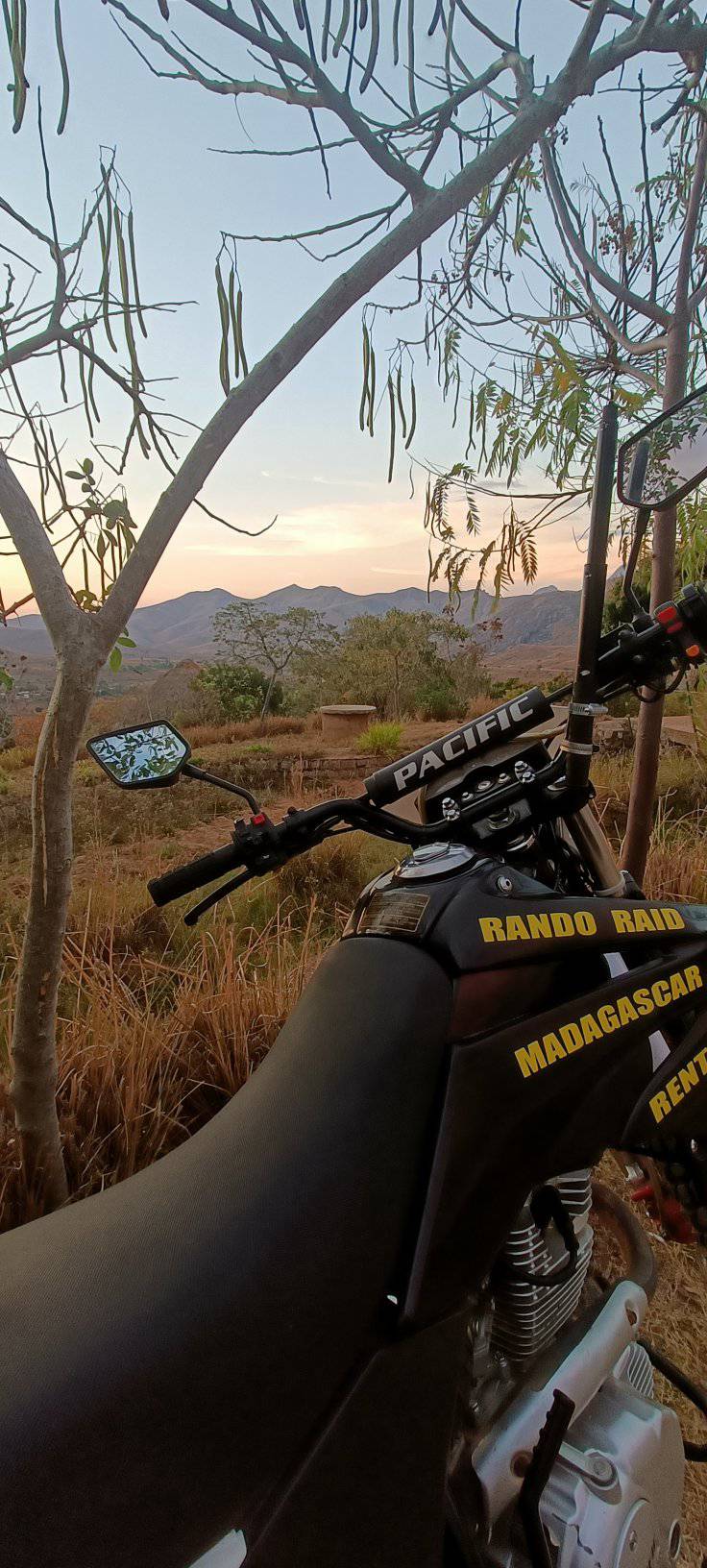
Also, I was solo on this trip, so wasn’t too keen on a heavy bike. After some research and google-translate supported email exchanges, I settled on a Chinese off-road model rented out by a small firm in Antsirabe, a city south of the capital. I found positive reviews online by European tourists, and the owner was quite responsive and helpful via email.
The minivan bus ride to Antsirabe takes about 5 hours and I’m happy I’m not riding a bike. The roads are narrow and busy. At the many corners and single-lane bridges, we have to wait for trucks to pass before proceeding. I watch the scenery, listen to the local music from the radio and enjoy the driver’s safe driving!
Day 0: Prep Day (Antsirabe)
After lunch, I pass by the bike rental place. Finally, I will see and feel the bike! Jean-Marc and I finalize the rental paperwork, and I get a hundred tips about the route, and what might be realistic in 17 days and what not.
Day 1: Exploring Vakinankaratra
Route: Antsirabe to Miandrivazo
It’s views after views!
Hilly, twisty, hot, dusty, and a lot of “former tarmac”
Day 2: Menabe Region
Route: Miandrivazo to Morondava
Heading 280km westwards towards the Indian Ocean. A lot of nothing and wilderness but I love getting a glimpse of life near the large rivers.
Just before Morondava to the right is the famous Baobab Avenue. Because much of Madagascar’s indigenous forests have been lost (not unlike Kenya!), protected areas like the Allée des Baobabs and national parks are important for protecting remaining tree cover and giving locals and tourists alike a vision of what reforestation could do for biodiversity!
When you’re on the West Coast of Madagascar, you can watch the sun set over the Indian Ocean!
Day 3: Beach Day (Morondava)
Today was a tourism day. It was also a planning day!
In preparation for this trip, I’d been researching about the next 200km. From Morondava to Manja is Off-road. Deep sand, pure bush, “strong enduro skills” needed, no network, no town and 4 “in the water river crossings” is what I found out. Sounds amazing, actually. But not alone and without camping equipment, medical kit or language skills.
If I can’t figure it out, I might have to backtrack to Antsirabe, which sounds super annoying. I get an offer of 1.5m Ariary at a hotel’s tourism desk, which is much more than I’d want to spend.
So towards evening I walk to the bus station and ask around (sign language + basic french + google translate) until an industrious bus ticket lady arranges a 4×4 pickup for me. 960,000 Ariary.
Getting money in Madagascar proves to be an unexpected challenge. Every second ATM isn’t working with my card. There’s also a withdrawal limit of 200,000 Ariary (about 50 USD) so everyone takes 5 turns at the ATM, so even if there’s money in the ATM, the queues are endless (up to an hour!). I also try to send money from my bank accounts to the local mobile money systems (unsuccessfully), and by this point I have three local SIM cards.
The most reliable and fastest way to get local currency was carrying USD and EUR in cash and exchanging in bulk at the bank counter.
Day 4: Wilderness Challenge.
Route: Morondava to Manja – on a pick-up truck.
An adventurous 6 hours drive, lucky I got a madly skilled driver!
Breakfast waiting for the driverThe equipment that will hold the bike on 200km rough roadSome rivers have bridges! 🙂The town half-way through
Manja has exactly one hotel, and all tourists stay here. I hadn’t booked. The main house is full, and I get a room in the neighbouring compound for about 5 USD (inclusive of some rodent visiting at night). They also sell sodas and beers so guests can sit on the roadside of the main village street.
And fuel from bottles. Fuel in Madagascar is green.
Day 5: Manja to Tulear
Brand-new tarmac and one river crossing.
First time I’m seeing Chinese road and bridge construction in Madagascar! The ride is quite smooth but not very entertaining. Until I get to the river. Which is much wider than I imagined.
From the two options offered by locals, I choose the floating ferry (that cars use) over the canoe (that locals use).
Getting off the ferry I have about 500m sand to cover, which is good fun. On the remaining 200 Kms tarmac to Tulear, more baobab trees give a coastal feel.
And now it’s time for a few beach days!!
Beach Day in Tulear
This is the Indian Ocean. Just like in Morondava, it’s a West-facing Coast which I’m so fascinated by. You get the sunset over the ocean!
Day 6: Tulear to Isalo National Park
Today’s 270km are loooooong. Starting from mangrove forest at the Indian Ocean, most was monotonous, empty landscape along the national highway RN7. Soooo few cars! I realize just how low the economic activity is. There is barely any traffic between towns.
My humble 200cc bike isn’t made for speeding, so I end up listening to many podcast epidodes today. This highway is in a pretty bad shape in some spots, and smooth in others.
There were just about 3 interesting things today:
1. A 3km stretch of protected indigenous forest remaining from the once lush thicket that must have covered much of the island. The level of deforestation is incredible.
2. A town that sprung up a few decades ago after gemstones (Sapphires) were found in the river. It’s a ghost town really, with most of the gemstone shops shuttered.
3. Golden Hour in Isalo National Park. Beautiful rock formations. Hikers paradise!
Bye bye to the Ocean for now!Vaaaast emptynessYes, this is still the National Highway!
I stay two nights, though in two different places. First I pull up at a family-run “ecolodge”. The shower water is being warmed in plastic bottles stored in a metal box standing in a sunny spot – genius! (But not as helpful for early morning showers). The food is fine but pretty basic. Of course I am offered rum in the family’s living room.
I try to arrange a hiking experience, to see some of the forest and natural rock pools in the National Park. But I find Madagascar’s National Park fee structure fairly costly, and the guide fee is dictated by the government and not negotiable. Even as a solo traveller, you pay the guide fee for 4 people. It is cheaper to get a full-body massage at one of the town’s hotels. To which I move for that second night 🙂
Day 7: Isalo National Park to Andringitra Mountains
I wake up alive which I find a big deal after eating crocodile for the first time in my life yesterday evening.
Today I plan to ride to the Andringitra Mountains, paradise for outdoorsy people!
After 100 boring clicks, the route is getting more and more scenic with huge granite mountains around.
In Ihosy I’m meant to get cash, fuel, snacks and do chain service. Both ATMs in town aren’t working so I spend 90 minutes to exchange some cash and forget everything else.
I pick up some snacks at a small town. The final 25km are offroad. It’s lovely cruising through the valleys, and testing the bike on its home terrain: rocky dry rivers and gravel turns.
The lodge is up a steep hill, what pretty views!
Exactly 300m to the gate, on a bumpy uphill, my chain chains. If this was to happen on this trip, this is the best spot. After taking some photos and updating my biker pal back in Kenya about my situation, I try to lift the chain back on the sprocket. But it’s stuck behind some metal and I just can’t lift it.
The lodge’s team comes with pliers and we open the chain then fix it back.
The poor bike isn’t starting but without batting an eyelid the lodge crew happily pushes it up the remaining hill and parks it at the reception.
We try to start it, kick it, push it, choke it, unchoke it, drain pipe it… Nothing! A little crank but no roar.
It’s getting dark so we decide to deal with this another day!
The place is so beautiful! The views of the mountains and the valley! I book a local guide for the next morning to take me around.
I unstrap my luggage and move into a beautiful round, tiny hut with a comfy bed.
Before dinner, I run into a snake and the owner of the place. He’s a famous French rock climber and he assures me that snakes are great news and that the valley’s bike mechanic will figure it out.
The Morning After Day 7.
After an early breakfast, I head out for a walk with my local guide and an animal spotter. We walk through the forest, and he shares some local tales.
King Julian!
Bike still isn’t starting. When kicking or pushing, it starts but immediately dies. Two of the hotel staff push the bike around the hilly reception area. They’re having fun but clearly there’s no progress. Something keeps killing the engine. Strange!
The Morning After the Day after Day 7
Location: Tsaranoro Valley, Andringitra Mountains, Madagascar
The morning after, the valley’s bike mechanic is called. He’s called Safi which makes me very happy. Calm, fun guy who speaks great English. Together we analyze the bike. Spark, fuel, air.
We have veeeery little spark when kicking the bike. By now we’ve finished the battery. We change plugs, we sandpaper the coil connector, still no sustained spark.
We try the mechanic’s bike’s battery. Nothing.
The team even pours some local rum on the bike. Nothing 🤯
It gets real hot, so someone suggests beers. This works – as we rest our brains, a new idea comes.
Let’s check if the chain broke something around the front sprocket, when it fell. And voilá, we find two strands of the cable coming out of the engine cut!
A minute and some tape later, the bike roars to life! Really grateful to the mechanic and the team. Lots of learning and fun across languages!
Time to enjoy the beautiful nature around the valley!
Day 9: Tsaranoro Valley to Fianarantsoa
From this beautiful location and the mechanical misadventures, it’s 20km back to the tarmac and another 100 or so of beautiful riding to Fianarantsoa.
But the main question in my head is whether I’ll be able to get a train ticket for my bike.
Exactly. I’ll explain.
I found this train that passes from the Highlands to the Ocean through remote villages and beautiful mountain scenery, dating from, you guessed it, the colonial times, but still operating as a lifeline to many villagers and an attraction to tourists.
Arriving at the train station just after 12, I find it closed for lunch. People here take lunch breaks very seriously, so I head out for some smoked fish, too.
At 3, I explain at the information desk that je veux voyager avec mon moto sur le train. I’m pointed to the cargo section where I can inspect the relevant car and I’ll be given a price. The only caveat is that the cargo car only goes up to Sahasinaka and I’ll have to ride the remaining 55km after offloading the bike, of which 15km “not so bad offroad”. Noone can tell the journey time, but 10 hours is the best estimate.
Which would mean arriving very close to sunset 🤔
No risk, no fun, I think! And I sure want to see the Eastern coast! Wouldn’t be cool to ride there and back the same route, right?
We load the bike on the cargo car where it’ll sleep for the night
Day 10: Fianarantsoa to Manakara
Train+Bike
I’ll let the photos speak for themselves today! But how BEAUTIFUL is this train ride, how breathtaking the views, how diverse the local crowd at each stop and yummy the snacks on sale!!
At each stop, dozens of people are ready for our arrival with various offerings. Beer, Pasta salad in small plates, samosas in buckets, cooked local dishes, steamed banana bread, etc
After the cargo car gets disconnected from the train in Sahasinaka, I strap the luggage back on the bike (whole village watching). Then I ride some pretty muddy 15km or so with the last rays of light towards the highway. I drop the bike in a deep long mud puddle and of course it falls head down into a trench. At this point it’s pitch black dark already. Gladly a local biker passes by the scene just a minute or so later and helps me to lift the bike.
This is (of course!) the last mud pitch 400m before hitting the main road. I cover the final 40km tarmac to Manakara town with smooth light bends up and down hills in total darkness listening to my reggae playlist.
After seafood dinner in town (La Vanille Hotel) where I meet the tourists from the train again, who were able to travel all the way until town in the passenger car of the train. After a mandatory ATM visit, I ride some fun 5km sandy tracks to their satellite camp on the beach! (Vanille á la plage)
Day 11: My Birthday! Beach Day
📌 Manakara, Madagascar
There is no power at this camp. My phone dies shortly after I speak to my family. So I end up reading and resting my knee from last night’s fall. And watching the beautiful wild coast!
Day 12+13 Manakara back to Antsirabe
I’m nearly finishing up my roadtrip through Southern Madagascar. Already! 435km left and I split it into two days.
First off: Riding back to town from “Vanille a la plage”. The canal is really fascinating. There’s a spot by the ocean where the road is sandwiched between the two. I HAVE to come back here with my tent!!
Didn’t see this when I rode down here at night.
And a little bit of rain makes sand easier to ride
The Canal in Manakara
Manakara to Ranomafana must be the most beautiful riding of 2023 so far! 182km worth of twisties, views, nature on mostly smooth tarmac.
Ranomafana National Park has some stunning indigenous forest, and could definitely be worth a hike. Well, I don’t visit any national park on this trip, because their prices for foreigners and forced group guiding fees just don’t add up for my budet. I take several stops along the way watching waterfalls and trees.
The road passing through Ramofanana National Park
But unfortunately by not entering the forest, I don’t see any of the cute chameleons with the curled tail 🦎
I’m a bit sad, but start my journey back to the city anyways…
From Ranomafana back to Antsirabe, I take a detour from the Google Maps route, as advised by local bus drivers to avoid an off-road shortcut that potentially has some bandits waiting, according to them.
On climbing up a hill, kids stop me in a corner to sell me bananas. (It’s school holiday).
The boys also have a small hustle going on where you can take pictures of chameleons for some cash.
Amazing surprise 💖
Later on the RN7 I found a good 80km of baaaad potholes. Entered Antsirabe by evening and found my first traffic jam in three weeks I returned the bike to the owner and we had a chat with laughter about my tour.
A massage is due! I decide to relax in this Spa town for a day, exploring local crafts and food in the market.
Then I take the bus back to the capital, Tana, and visit the famous Analakely Market on my last day.
All good things come to an end. I travelled around 2600km in Madagascar, of which 1930km on the bike.
Amazing adventure! And certainly only saw a fraction of what there is What a massive and diverse country!
Highly recommend Jean-Marc Ney and the team at Rando Raid in Antsirabe for Motorcycle hires in the southern part! In my research before the trip, I also found other providers renting bikes based in the capital Antananarivo, and I’ll share them here. (I also found individuals renting out bikes by posting on facebook groups)
You’ll find them on Facebook or Instagram
* 100% Moto Madagascar
* Just Ride Mada by Rhyno Jesse
* Moto Tour Madagascar
* There’s also Badass Motorcycle Community, a biker restaurant.
If you know additional biking resources or contacts in Madagascar, feel free to add below in the comments.
Y’all know the itch when there’s a route you want to try out?
What if it’s 1150km from home? When I rode to Rwanda in July, I missed seeing a small corner of Uganda, that I had heard so much about: The Kabale Kisoro twisties. 🖤💛❤️🖤💛❤️
There is also a very specific spot I wanted to go swim at near Moshi in Tanzania: Kikuletwa Springs. And a mountain to hike that a flower is named after that I remember from my childhood.
In short: East Africa was calling.
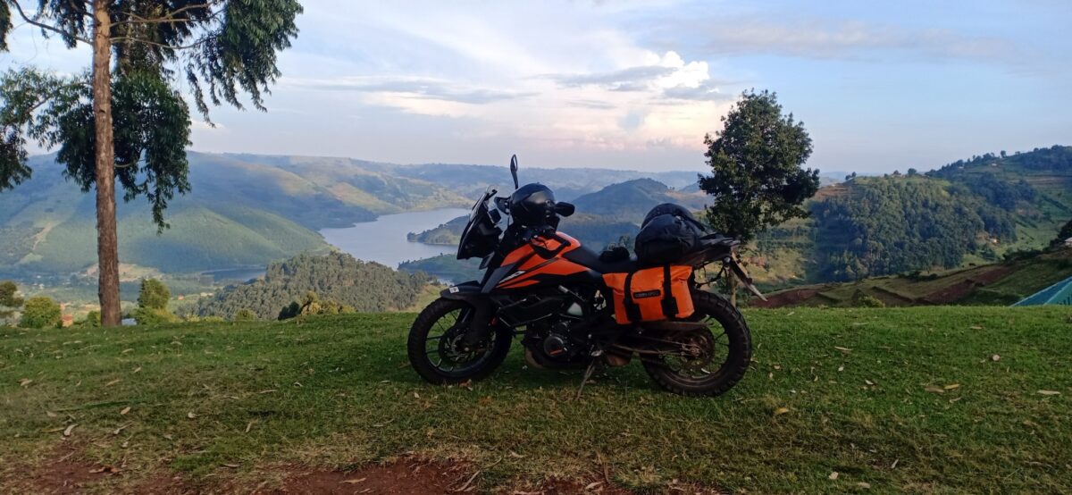
I acquired (and then lowered) a pre-loved KTM 390adv just a few weeks before Christmas. The new girl’s logbook came through last minute, so out we were!
A 3-week trip through 4 countries covering over 4,600 km – which I’ll share with you in 3 parts:
Part 1: Nairobi to Lake Kivu. Glances at Lake Bunyonyo, the Impenetrable Forest and a bunch of hair needle turns made me forget the rough Kisumu and Kampala Xmas traffic 😎☺️💯 Sunset at Lake Kivu should be on everyone’s bucket list 💙💙💛💚
Part 2: Kivu to Kili. Exploring beautiful roads with friends. Plus New Years in Kigali and a few bike repairs on the roadside
Part 3: Usambara Mountains to Diani and back to Nairobi. Hiking, swimming and relaxing!
Route looks fun, right?
Now here’s part 1!
PS: A detailed explanation of the border crossing procedure and requirements can be found in an earlier article here.
Part 1: Nairobi to Lake Kivu (3.5 days)
Maybe leaving Nairobi on Friday 23rd December at noon isn’t such a brilliant idea. But well. I set out westwards from Limuru down the Mai Mahiu route and aim to sleep in Busia.
All packed! What could possibly go wrong?
After circumventing some bad traffic down the escarpment, I head towards Narok and Sotik: Sweet empty roads! Some rains to bless the journey!
Just before Ahero, I find some mad traffic.
After kms of tight lane splitting, things get no better.
When the rain starts and some kadudu car gets stuck in front of me up a muddy hill, I decide to take a break.
The locals welcome me home and explain that I’m witnessing the Annual Migration – “they only visit once a year”.
I have dinner at the petrol station. The jam moves by 15 metres in those 90 minutes.
As night falls, I decide to just look for where to sleep. Magic! The petrol station has some rooms – with running water! And that’s how I only manage 320km today and sleep in Ahero 🙂
I’m up at 6am with a goal to sleep in Mbarara in Southern Uganda – some 600km away. But I find the same jam outside my window!
With day light, I’m able to navigate around the traffic easier.
Once past Kisumu town, roads are empty and I’m finally able to twist the throttle. When I rode here in July with Havana, I used my 125cc bike. I’ll one day write about this bike upgrade. Right now I enjoy averaging 100 km/h as opposed to 75 on empty roads – saves time and feels comfortable and safe!
After a triple banana breakfast in Luanda, I find looong queues at Busia border crossing. I’m not the only person trying to get to Uganda this Christmas!
It’s already 11:30am by the time I leave the Ugandan side towards Kampala. I stop for a late lunch at Java in Jinja, and it’s 3:20pm when I get to the Nile bridge in Jinja. I still know the route to the old bridge off-head and take some forbidden pics of the forbidden new bridge.
Riding through Mabira Forest Reserve, I witness a police pick-up car chasing down boda bodas carrying firewood that was evidently illegally logged from the forest. As one boda falls on the roadside at high speed, I wonder how the maths of poverty, climate change and conservation will work out over the next years.
Approaching Mukono the traffic gets really tight. It is indeed the 24th December, and people are travelling for Christmas! I’m already tired of lane splitting, going slow and tip toeing on the tall(er), heavy bike!
From Kireka I take the bypass, which is blissfully empty. What a spirited ride, with captivating views across the many hills of Kampala!
Once the bypass ends, the jam and the chaos starts again. I’m taking lessons in lane splitting from the bodas – we think bodas in Kenya do risky stunts, but please go see for yourself in Uganda!
Before long, the sun sets and I stop for pics at a petrol station. The askari approaches me and tells me I’m not allowed to take photos of the petrol station, nor my bike on the sidwalk next to the petrol station. So many beautiful things to experience in the Pearl of Africa – just don’t let such issues dampen your mood!
For safety I decide against pushing onwards to Masaka. I pull up at a hotel with good Google Maps ratings just after Kampala. It’s Christmas and they are offering massage and steam bath. Why not?
353km today!
Day 3 – Finally Open Roads!
Good morning! My goal is to ride the Kisoro twisties, then sleep in Kisoro, at the DRC border in Southwestern Uganda – which is 460km away.
I agree with myself over breakfast we’ll be minimizing photo stops.
At the Equator sign I have a very pleasant conversation with a Muslim family. It’s 25th December and I ask them where they’re travelling for the holiday. Big blunder. I’m informed that they are not on holiday because it’s Christmas and they’re not Christians. Semantics across cultures are always fascinating!
South the Equator, the road gets pretty empty. The rumble strips are just too many and at some point I have a sharp pain in my lower pelvis. I realized that the KTMs suspensions are great but maybe not great enough to protect my inner organs from being violently shaken, when lazily sitting on the bike. Henceforth I stand and bend at the rumble strips.
EDIT: A reader reached out and asked about this. So let me say a bit more: On this and earlier offroad-rides I’ve experienced random (i.e. not cycle related) cramps and even light bleeding when throttling over corrugations or bumpy patches repeatedly. Men may or may not experience this, because well, their organs in that area are different and any blood from light blood vessel tears may not necessarily come out (or would it?)
I’m really not the expert here, but I was taught at Offroad Adventures that the best way of avoiding riding related damage in organs (kidney, ovary, spine etc) is taking the following riding position: Bending forward (hinging forward, really) at the hip, therefore completely disconnecting the upper body from the rattling and shaking that the bike and lower body go through. Looks less cool than standing upright on your GS but gives you much better control of the bike, too (centre of gravity, elbows out, and all that). Happy to learn what others have experienced – leave a comment or reach out!
Before long I’m in Mbarara and take the Bypass towards Kabale.
It’s very pretty and I seem to have forgotten the issue of photo stops.
I’m just about to enter the twisties where we had our unfortunate accident half a year ago, when it starts raining heavily and I stop.
As I buy some water and chat with a shopkeeper and his daughter chilling under their roof, a local boda passes by with his christmas drink. It’s a kind of silly but very peaceful moment. I think of my friend who’s still recovering from his injuries he sustained near here. I also think about how unquenchable the thirst of adventure is.
The Kabale twisties are just so beautiful, despite the rain!
The trip counter shows 385km when I stop in Kabale for some samosas. I’m VERY excited about the route to Kisoro down the escarpment.
But first the road passes through beautiful hills, quiet villages and allows beautiful glances across Lake Bunyonyo
Oh boy! So pretty! We’re getting closer to the DRC and I pass a friendly military stop. And then I get to some steep hair pin turns.
I spot a cone in the distance, which turns out to be Muhabura Vulcano at the border with Rwanda. I’m in Gorilla territory now!
I get to Kisoro around 7pm, and Google Maps takes me through an adventurous rough road to my destination.
Dinner takes two hours to prepare, so I get to edit a helmet cam video. Enjoy a few twisty kms from this evening on this video link!
465km done today!
Day 4
Today I’ll enter Rwanda and ride along Lake Kivu. It’s only 180km from here to my friend’s place!
So first I want to explore Kisoro town! I also need to get some UGX from a bank because I ran out of cash due to spending an extra night in Uganda.
There’s quite a number of children and adults asking for money on the streets. We’re just a few kms and a (closed) border away from the DRC, where rebel groups are turning peoples’ lives into hell and making them flee their homes and land.
Being stared at and followed by people under the influence of alcohol makes me enjoy the walk through Kisoro town less and I head back to the hotel. I meet a Ugandan rider who’s attending to his bike and who’s planning to cross to Rwanda today, too. Around noon I head towards the border, very sure he’ll catch up with me.
Can you see these rumble strips? Nuts!
It’s a swift 15 minute twisty ride to the border town Kyanika – these corners are troublesome to trucks, as evidenced!
The border crossing at Cyanika takes much longer than expected. The Ugandan side is cleared in 5 minutes, but the Rwandan customs official takes at least 75 minutes to type my details into his system. More than enough time for the Honda NC 750 to catch up!
On entering Rwanda, we are welcomed by five speed cameras in quick succession. As he’s headed to Kigali, we part ways at the next major junction, and I have around 100km left for the day.
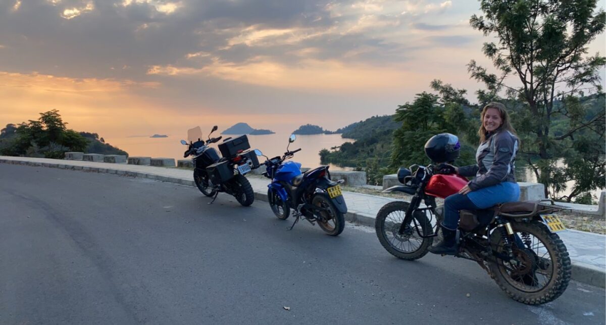
Once at the Gisenyi junction, I recognize different spots along the route and start missing my riding buddy Havana! Other than some brief drizzle, it’s beautiful, twisty riding along empty roads and relaxed villages.
The beautiful sight of Lake Kivu in the distance!
The speed limit of 60 is trickier to keep with the KTM than it was last time with the Spirit, y’all!
Entering my pal’s town Karongi with the last rays of sun!
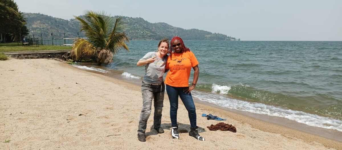
Just in time for a breathtaking sunset over Lake Kivu!
And a huge fish for dinner 🙂
And here’s the best part of the trip: One of Havana’s BIG HUGS!
Happy Holidays and Merry Christmas, everyone! Wasn’t 2022 epic?
This month I’m working from my friend’s house at Lake Kivu. Over the weekends, we wish to explore the beauty of Western Rwanda together on two wheels!
Havana and I rode to Kibuye, Karongi district from Nairobi. You can read all about the 1373km trip through Uganda, incl. our preparations check-list on this earlier post.
Kibuye/Karongi town itself is rather quiet, and has a rural feeling to it. The main feature is the lake. It’s just sooo beautiful 😍
Some impressions of town:
The lake so awesome! One night we go for a sunset photo shoot.
And before long – Weekend 1 is here!
We plan to ride South to the famous Nyungwe Forest on Saturday morning, and ride through Butare back to Karongi. The return route will include an 80km off-road stretch. We decide to split it into two days and find a nice place to stay in Nyungwe Forest and make an advance booking.
The plan:
(Spoiler: It never happened like this…)
Two long days in the saddle again? We’re still suffering from the 3 long days on our bikes on the way here! We’ve been sleeping early to combat fatigue and be effective at work. One evening I decide to scavenge facebook for a massage place. We succeed and book two deep tissue massage therapy sessions for Saturday morning. They are back to back because there’s only one therapist, but by 11:30 we plan to be on the road!
Lovely place. Friendly team!
While Havana is having her treat(ment), I head out fuel the bike and then tighten the chain. It just takes 3 minutes and I was honestly too lazy during the week.
The chain situation
I pull out my spanners. I quickly realize that the chain cannot be adjusted further with typical means. The back axle is at its furthest point out. 😲 Kids assemble and watch me curiously while I think.
Havana shows up from her massage incredibly relaxed while I’m getting some advice from my friend in Nairobi about the chain issue. Can I find a fundi to remove a few links? Will it be tight on the back sprocket or is it just too worn out?
We agree that it’s not worth risking to head out like that and call our trusted local boda to point us to the right fundi.
He’s somewhere near the main bus park. Yes, that’s the main bus park of Karongi town. See your life!
Havana makes new friends while the fundi gets to work
We’re welcomed and the chain is out in 5 seconds
Fundi turns into dentist and knocks out two chain links
The old chain is stretched too much. It’s not sitting neatly on the sprockets whatsoever. This is not great!
There’s something I haven’t yet mentioned about Rwanda. The language is Kinyarwanda, which I don’t speak or understand. If you interact with the common man you gotta figure out how to communicate – remember that you’re the guest here! Some people speak some Swahili, others speak some English, and there’s also a bit of French (but my French is just too rusty).
Around my bike we have our trusted swahili speaking boda who doesn’t speak english, the fundi who speaks a little english but no swahili and around ten bystanders who speak in hushed Kinyarwanda to each other. We make the triangle communication work somehow and add in just enough pointing and sign language to cook up a plan.
There’s a new Chinese-made chain with the right specs (as per the manual!) available. It’s 10,000 RWF, approx 1150 bob. Our friend in Kigali calls his fundi but we can’t seem to find a Honda chain and sprockets in Kigali fast enough, so we go with this one. It fits like a glove!
Kinyarwahilinglish is a perfectly functioning language!
As I pay, the fundi tells me he is still new and has a lot to learn. I found his chain work sensible and encourage him to check out youtube videos but he lacks a smart phone.
We take selfies and bounce!
The Plan, version 2
It’s nearly 1pm, so we can’t do the original plan anymore. We agree to do a quick dash up the border town Gisenyi, close to Goma. It looks like an epic route with a million twisties!
We head out from the fundi and ride up the hill leaving town. In the first corner I realize that my back braking power is zero. At least I know what’s going on. My DIY mentor would be so proud of me. I stop to adjust the drum brake’s cable that is now totally loose given the back axle was moved all the way front.
Now we should be set! Let’s head out!
A final glance at the incredible view across Lake Kivu! Soon, the road moves away from the Lake and we ride through a mountain range. It’s just corner after corner for an hour. We get ino a good riding rhythm with some photo stops, happy smiles as we both bob our heads to our playlists.
There are deep trenches along the roadside. An amazing rain water management system along the slopes. Some good thinking was put into constructing these roads!! We get the purpose but it doesn’t make it less scary in corners…
Roads are fairly deserted but one thing that stands out are the well behaved mini buses ferrying people and goods from town to town. We also meet small children chilling out in the trenches and watching us curiously. Some jump on the road in excitement and wave. The speed limit makes sense after all!
The views!
It looks like it might rain. We’re trying to make mile but it’s also really cold suddenly, so I stop to put on my windproof rain jacket over my mesh jacket.
And then:
Are we in Karirana!? Wow! The last thing I expected were tea plantations. I start wondering what came first: the cold or the tea!
We should be close to Gisenyi now, and soon descent back down to the Lake!
Can you spot the Lake in the distance? We haven’t seen a lot of people on this afternoon’s route, but now the road is getting busier. Lots of people are walking. Many bicycles ferrying cargo and very few bodas.
We enter Gisenyi and cruise along the lake shore
Passing by a brewery!
We are at a few hundred metres away from Goma, Eastern DRC! How epic is this!? We HAVE to take a selfie at the border! I put the border post on my Google Maps and bluetooth guides us down a road until we reached a well-armed and closed barrier.
We are a bit puzzled. Are we even allowed to take photos here?
We watch some local women shout and scream at the unmoved soldier manning the barrier. The whole situation is not very inviting. A screenshot might need to do!
YESSS!
It’s 2 hours to darkness and we’re a thousand twists from home. But first things first: Lunch!
What an inviting sign post! We pull over and find a beautiful garden restaurant.
We’re served with the most yummy marinated grilled fish. By now Havana and I can read each other’s minds. Kwani, what’s the rush! Let’s sleep here and explore the town a little!
We get through a few local beers and a friend who happens to be in town joins us. I learn that Gisenyi is a party town and attracts weekend guests even all the way from Kigali!
Some people may or may not have gone to sleep while others may or may not have gone out to experience post-covid nightlife!
Sunday I wake up with renewed ambition to get a good border picture!
After breakfast we pack up and explore town a bit
Near La Corniche
We pass by the Rwandan side’s airstrip, which is literally across the border fence from the Goma airport. Just a reminder how weird this border business is!
We reach the border area and are a bit more courageous today. We ask the soldiers if we can enter and take photos. While one answers yes, the other answers no. “Don’t take photos of offices” is the conclusion. 👍 We park the bikes and take a stroll down past body scanners towards DRC.
We see cargo (diapers!) but not sure if it’s flowing east or westwards. One final conversation and we get permission for selfies at the final barrier!
Of course we get permision – because we’re glowing, happy, harmless tourists!
We’re excited! Why didn’t we carry our passports? We’d have hopped into Goma for lunch!
Next stop: The beach! We find a Serena hotel on Maps and decide to go for juice and to chill a bit more before riding back home.
It’s other-worldly. We are standing at a 5-star hotel’s beach in Western Rwanda staring at the water towards DRC. The news of the recent refugee crisis and the R23 rebel group’s strikes? We know of it. We can’t see it.
Expats are playing with their kids in the pool.
People are swimming, watching us curiously with heavy boots on their beach. Biker manenos 🏍️ 🤣
We chat over some fresh extra tasty juice and gear up to start our return journey.
I pretend to take photos of Havana but really: I’m just here for the colourful Kitenge clothes!
We’re going to be riding back the same route we came yesterday
Today we are more relaxed and well fed. The new chain is working and we know what to expect on the road: Corners, hill climbs, hairpin turns, long descents and views! 🐍🐍🐍
Exactly!
On one of those looooong winding roads I follow a bicycle loaded with gunias of produce. These people are fit!! They just push the bike plus load uphill. You won’t see many motorcycles as in Kenya or Uganda.
He’s doing a clean 50 downhill! Leaning into the corners with his heavy luggage on tiny bicycle tires. That’s real skill!! I’m very impressed and overtake him to stop and take his photo but as he shoots by me he’s too fast and I miss him 🤣🤣
Sometimes you see the road you passed a minute ago juuuuust across a valley
The road turns left, but you can see it re-appear on your far right
By the time we get back to Karongi we have graduated with a Masters degree in Lean Angle Management!
The Lake welcomes us home
We chill for the rest of our Sunday, intoxicated by our dopamines and endorphins!
Maybe next weekend we’ll make it to the famous Nyungwe Forest?
My biker pal’s job moved her to Lake Kivu in Western Rwanda. She had brought her clothes and favorite coffee mug with her by plane, but life was not complete. She was raving about the incredible roads, beautiful scenery and amazing riding once Mugabe would make it to Rwanda. Mugabe is Havana’s bike, a hoooot blue Gixxer 155.
We kept chatting as she settled into her new home, about the farmfresh food, the good air, beautiful lake views – and so we cooked up a plan to ride down together and for me to stay for some weeks before riding back to Nairobi.
How to prepare for such a trip?
Ages ago I lived in Uganda and had visited Rwanda several times, but riding there over a quick long weekend!?
Our preps included
Setting expectations. Two full blown adults spending 4 days or rather 3 weeks together. How would we ride safely together? Keep the mood upbeat considering it was going to be exhausting? Spend our days as we would both be working demanding kick-ass jobs, once in Rwanda?
Route planning: With 280cc combined, how would we split the 1300kms? Into how many days? Where to stay and eat lunch? What’s the climate/weather along the route? What are the heavy traffic areas/times, and how would we avoid riding into the night?
Paperwork planning: What’s needed to cross the border? Ride legally and safely outside Kenya?
What Google Maps says
Check-List for our East Africa roadtrip:
Must haves
First aid kit and skills
A trusted buddy to share our ICE details with and be our trip’s “virtual escort”. Esp if alone, share live trip updates so they can check up on you. Thanks to the one and only for offering to be on stand-by!
A waterproof document envelope thingy, because:
Passport/ID: We both didn’t need visas, but as a Kenyan resident I needed an interstate pass to avoid visa fees in UG+RW (print from eCitizen)
Logbook – which should be in your name. If bike is not in your name, take logbook and a letter from the owner outlining your travel itinerary to KRA in town before departure so they issue you a temporary permit. They will ask to stay with your logbook, but if you will cross another border on your journey, you can’t leave your original logbook with them of course. So just explain that and go with it.
Valid driver’s license
COMESA insurance for the bike. This is an extension of your normal bike insurance, so has to come from the same company
Yellow fever vaccination certificate
Covid travel requirements – at the time we travelled, a vaccination certificate was enough to cross the land borders. This may vary! We still took a rapid test to be sure.
4 copies of everything, as you will leave copies at each border.
There are no payments at the border. Unless you want to tip a broker to help you figure out where to queue (which really isn’t needed)
A pen to fill in the immigration form.
Enough cash for fuel, accomodation, eventualities. Do not rely on your bank card or mpesa to work. We carried USD (in fresh 20$ notes from a forex bureau) and KES. I couldn’t find RWF in Nairobi and the UGX rate I was offered in forex bureaus was crap, therefore opted to exchange at the border. Knowing the official exchange rate can help you negotiate.
Know the country’s road rules. e.g. TZ and RW have speed limits! What do yellow or white lines mean? etc
ATGATT – don’t go easy on that just because the roads are less busy or it’s hotter than home.
A clear, free mind: Safety mindset, defensive riding 101%
Check if your private health cover will sort you beyond Kenya. Get details on how it would work and phone numbers
Bike tools, serviced bike incl. a thorough bolt, chain and bearings check
Important stuff
An evacuation cover. What if you crash and there’s no good hospital around? How will you reach home in your injured state? Check out e.g. AMREF Maisha cover (link) It’s a good idea even in Kenya, but the cover for neighboring countries is slightly more so you might need to upgrade if you have one.
Data bundle. To create FOMO inducing insta posts, update your trip buddies, call your fundi on whatsapp, etc. Roaming on another country’s network with your SIM card can be expensive. You could rely on wifi in the hotels, but how will you deal with an emergency? I bought the Airtel One Africa bundle for 1100 KES for 10GB which covers UG, RW and 10+ more countries. It worked magic: A seamless online experience.
Enough airtime on Safaricom to make emergency calls. Airtel network might be low in some places. Safaricom tends to roam on the stronger networks.
Power bank. Adapter for Rwanda-shape sockets
Nice to haves:
Look up accommodation options in advance to avoid looking for places late at night. Go through the reviews at the comfort of your home. We made bookings on booking.com. Some hotels allow reservations without upfront payment or entering card details. Or get their numbers from Google Maps and make a booking via whatsapp. It tends to help if someone expects you at night in a foreign land (we will come back to this later :-S )
Emergency contacts of bikers on ground in case you need assistance. You might be a loner and don’t want to mingle. Fine. But at least get a number and let them know you’re visiting. Or you might make a dozen new friends and have the cultural immersion of your lifetime!
TP, wet wipes, musli bars, basic meds like pain killers…
and so on…
Soooooo, how does the border crossing work?
The border procedure has two aspects and you have to clear them with both countries. Once you understand the logic and are confident you have all papers, you will not worry much about needing an agent/fixer to help you at the border.
1) Immigrations for yourself (ID/passport, yellow fever vaccination certificate, covid vaccination/test certificate, they’ll take your fingerprints and photo)
2) Customs for your bike (Logbook and copy. Copy of ID/passport. All copies will stay with them. They will register you in their system and issue you a temporary permit to take the bike into their country. They might counter check the chassis and engine numbers, so know where these are on your bike.)
3) To ride legally, you need a COMESA insurance cover for your bike and of course a valid DL. You probably don’t need to show these at the border but at police stops.
So much for the preps! It’s a full-time job in itself!
Here’s our story of riding to Lake Kivu 🙂
Day 0 – Head start to Naivasha
We wanted to reach Jinja on our first day. And we wanted to reach before sunset. This was going to be an overly ambitious ride from Nairobi, and with our “small bikes” we would need to leave around 4am – in full darkness and with July cold.
A biker friend was willing to host us in Naivasha for the night, so we left Nairobi on Friday at 4pm. Quick viewpoint stop and hot drinks at EsQoffee.
We are soooo ready!!!
I want to say it was an uneventful ride down to Naivasha, but we meet a few naughty drivers on the road. Once in Naivasha, we pick up pizza and proceed to my pal’s house where we have chats over dinner. We debate the best route (Eldoret? Kericho? Londiani?) and settle with Londiani, with some uncertainty of where we’d find a great breakfast along that route. After a hot shower we set our alarms to 5am and sleep early, dreaming of the next 1200km and two border crossings.
Day 1 – Naivasha to Jinja
We head out from South Lake Road by 5:45am and enter the Nakuru highway with the first sun rays. Our ride through Gilgil is freezing but we’re making good speeds and before long the dual carriageway welcomes us to Nakuru.
Sun is up – Nakuru at 7:10am
After a fuel, water and toilet break we head out towards Londiani. There’s a rather narrow uphill section with lots of tree twigs indicating broken down trucks. We count at least four (or were they just parked!?). I had replaced my front tire just before this trip but the grip is great so far.
Google Maps maneuvers us off the highway towards Londiani junction and from here it is a breathtaking journey. We start to feel our empty stomachs but can’t spot any breakfast places. Even the few kibandas look closed!
These three beauties!!!
Then we spot a signpost on the left: Koru Country Club. It’s a petrol station with choma and what looks like a restaurant! We enter and park the bikes. Many sets of eyes on us as we climb off the bikes and celebrate our progress so far! 198km in 3.5 hours! Not bad 🙂 Fresh Juice, and a hearty breakfast.
10am. 305km to go.
Next stop Kisumu, we agree.
We pass through sugarcane fields and that smell near Muhuroni’s sugar factory can wean you off sugar, I want to believe.
This is not a stop. It’s just a photo break
On approaching Kisumu town, I spot the signposts indicating the bypass. Google Maps on my bluetooth is quiet. Maybe I forgot to click “start” and going straight will get us into a huge traffic jam in town? I turn and take the bypass. Big mistake! The bypass has over 20 huuuuuge, steep and violent speed bumps. It’s not just annoying to ride over but we’re also slowed down by the trucks as they navigate the bypass at snail pace.
We finally get to the airport and stop for pictures, high fiving ourselves for the progress. Havana is just toooo nice. I would have been pissed with the lead for that choice of route, yo!
From Kisumu it’s another 110km to the border. With our late breakfast, we say let’s push through and eat at Busia. We run into lots of slow trucks on a narrow uphill towards Maseno. Once past Luanda, the road is empty. Until we find ourselves in the middle of a political rally in a small town. A good hundred bodas and maaaaany people are standing/walking on the road. They are going in our direction but still – we could get stuck in the middle. I signal to Havana whether we want to stop and wait this out, but we somehow manage to squeeze through.
Before long we enter Busia town. Trucks are lining up along the roadside waiting to enter the border area. A guy starts running next to my bike speaking with me for a good 600m. I’m listening to music in my helmet but figure that he’s one of the agents that wants to help you with border clearing for some cash. We had agreed not to use one, so I keep riding and we enter the huge border parking lot. I ask an askari where to park, and the agent answers. I tell him we won’t use his services politely. He keeps running next to my bike.
Once parked at the border office, I tell him off less politely and we ask a Kenyan police officer for where to start and she points us to the KRA counter.
After processing our papers on the Kenyan side, we proceed to the Ugandan side. The only negative experience is the toilet. I arrive there with swaths of women who just got off a long busride, clearly pressed. We all get yelled at that we should not even consider using the toilets without payment. In short “Lipa Kwanza! Ni nini!”. I mean, woooow.
Uganda side immigrationsSelfies after exchanging money at a pretty sensible rate with some guys walking around with huge bundles of notes. They wear coats with numbers and seem registered.
We roll into the UG side of Busia. Total one hour and 15 minutes 🇰🇪 -> 🇺🇬 . It looks the same. Until we see the Shell petrol station. 6180 UGX per litre. That’s 195 bob! We consider turning back just to fuel in Kenya @ 160. Well, not really, coz small bikes don’t mind such issues toooo much.
We look for lunch!!
Steamed matoke, skuma wiki and beef stew at a Kibanda. 6,000 UGX is around 200 bob.
I switch mobile data from Safaricom to Airtel. My Airtel Africa bundle works perfectly.
Excitement! We are in Uganda. Smooth border crossing! 117km left. We had been told there might be some construction along the highway. We leave Busia at 4pm with optimism we’ll make it to Jinja by sunset.
I’m entering honeymoon state. Few cars. No drama. There’s one diversion for bridge construction but it’s short and fairly painfree. We’re riding through open green fields and it’s nice riding. A mix of Kenyan and Ugandan number plates.
Around 60 km in a probox kinda car approaches me from behind. I’m following a line of cars, there’s oncoming traffic and we’re all going at around 80km/h. In short, there’s nowhere the car is going. He comes reeaaall close to my number plate and starts flashing his light. I ignore him but start scanning the side of the road for an escape route. There is a narrow gravelly path before a deep ditch – it’s a 15cm step down from the highway. This is when the big boys show the car dust, but what to do? At some point he disappears from my mirror. Not a good sign. He has entered my blind spots and is right next to me. A hand can fit between my and his mirror, but not more. He basically pushes me to the side and I carefully ride down onto that ditch-y path to avoid being hit. What an asshole. He and his passengers even have the guts to open all their windows and gesticulate that I should be riding “down there”. I stop the bike for a few seconds and breathe. After letting a few cars pass, I get back on the road. As fate has it, the cars are building up at an uphill, and I overtake all cars including my friend. I avoid seeking eye contact. We know how this could end.
Honeymoon ends abruptly. By the time we get to Jinja, I have another 2-3 cars pointing me down to that “side lane”.
Ignoring all emotions, we continue riding safely and before long enter Jinja town. By now it’s beautiful evening twilight. We still have time to ride down to Lake Victoria!! A quick Maps check tells us there’s a road along the shores of the lake and we can ride back up towards along the Nile.
We hit the road and find tarmac ending soon.
We get a bit unhinged and follow a steep single track down to the water.
Mugabe does well in his tarmac shoes!
We find this railway bridge across the Nile. Lots of people walking and bodas cruising on the walkway under it, as we look for a the best photo angle
Aaaaahhhh!!!
After saying hi to various local riders, we ride back up to the tarmac.
Jinja roads are fairly deserted. As we cruise around to get a vibe of the city….. well and find our hostel
We check in at Jinja BaseCamp for the night. We didn’t pick it based on rating/recommendation but because it was the only accomodation within our price range where we could make a booking online without card details. The team was welcoming, there was free drinking water. The room was not exactly spacious, but we only needed to shower and sleep. The manager was so kind to help us order dinner in from a restaurant.
Imagine, we finished it all!
We inform our people of our arrival. 517km done! Smooth border crossing. Sunset pics at the Nile.
What else do you want?
Day 2 – Jinja to Kabale
We wake up early, pack up and load the bikes. We’re out of the gate by 5:30am because the goal is to have breakfast in Kampala – a quick 82km away – and be out of the city before the Sunday traffic locks us down. But first we look for fuel in Jinja. There are two Shell petrol stations, both still closed, so we end up at a no-name pump.
Various Ugandan bikers had informed us that motorbikes are not allowed to use the main bridge over the Nile and we didn’t find it worth the risk of being arrested. I chat up a car driver and ask him about the route to “the other bridge”. He is visibly confused that bikes are not allowed to use the main bridge. His passenger even challenges me to use the bridge and see if I’m being denied entry. On seeing the passenger’s white police uniform, I decide to withdraw from the conversation and that Google Maps will serve us just fine. But the driver ends up talking to a boda guy to take us across the bridge.
And off we go through a dingy, dark, muddy rough road 🙄 . The sh*t bikers go through, I tell you!! In the end we arrive and ride over an older but functioning bridge and on the other side I tip the boda.
From here we finya the bikes out of Jinja. We really want to get to Kampala before the city wakes up! But first we have to cross Mabira Forest at night. It’s pretty chilly and I follow a Noah who lights the way for us. He doesn’t seem exactly sure of the road, which works for us as we average 70 on the bumpy road through the dark forest. At some point I realized it’s a KCN number plate. The guy is equally new here like us 😉
Once through the forest, the sun risesWe ride through misty hillsThere’s always time for selfies!
We ride through Mukono and I marvel at how the place has developed. Obviously – it has been 10 years since I last visited!
We get to Kireka and have the choice of going straight through town or turning left to take the bypass.
Remember what a bad idea it was in Kisumu to take the bypass? It’s Sunday 7:15am so we decide to cruise through town. Within a few minutes we pass Banda and take the Lugogo turn, then Upper Kololo Terrace past the airstrip with a few glances over town. Empty roads and I’m so thrilled to be riding in Kampala. This is where I started my biking career back in 2010: as a boda passenger.
Within a few minutes we park outside CJs and enter for breakfast. Havana’s friend joins, and a few members of Uganda Bikers Club as well. We have a great time. It just feels wonderful to know you’re part of an East African community of like-minded people. They even offer to escort us towards the southern side of the city although they are heading out the other direction for a CSR ride for Rhino conservation!
On leaving the restaurant, we find traffic bumper to bumper.
Our hosts take us through busy city roundabouts, where at some point a boda falls right in front of my front tire. His two passengers quickly pick up their many little boxes and abandon him to pick up his bike. We get to the Northern bypass and our escorts wave us goodbye at the final turning.
The next 66k takes us ages for some reason. Or maybe it just feels slow. Up and down on a very straight road with a small engine can feel like that.
Stop to change the playlist. Maybe that will help!
By the time we get to the Equator sign, we wonder if the day will ever end. 11am and only 160km done! 343km to go to Kabale all the way down near the Rwandan border!
We continue towards Masaka, then Mbarara. I can’t say that I enjoyed this part of the ride. Soooo many rumble strips. I remind myself how to stand on the bike hinged forward at the hip, disconnecting the upper body from my legs. I learned this in a recent offroad training: You want to avoid that these violent vibrations affect your inner organs.
Louder for the people at the back!
At some point we ride through a very long swamp. Dried and fresh fish is being sold along the roadside. I’m curious and stop but the language barrier prevents any conversation.
Then I see a bus approaching from behind. It’s an open empty road. I’m doing 85 so he’s easily doing 100. I’m used to busses in Kenya overtaking me closely, at least halfway in my lane. The opposite lane is EMPTY and he has at least 800m open visibility to overtake smoothly. But this guy doesn’t move to the other lane by even a single inch.
At some point he’s just a few metres behind me. Seemingly happy to roll over me. I move off the road. In the next town find him at a speed bump. Of course. Overtake or not? Obviously some drivers get pissed by this, thinking you’re challenging them while you really just want to get to your destination. I let him go.
As if this wasn’t crazy enough: A bit later, again on open empty roads, an oncoming car pulls over from his side of the road to drive towards me in my line, looking directly at my face.
My conclusion at this point is that while Uganda might have less traffic and fewer careless drivers, there is a special breed purposefully putting you at danger.
We find more and more rumble strips and it gets hot. We take another water break and make it to the lunch place just before Mbarara by 2:30pm, an hour behind the plan. We find two bikes in the parking lot. Our escorts from Rwanda made it here before us!
A beautiful golden (!) Transalp and a Suzuki DR 650 😋
Get-to-knows and conversations over lunch. Two experienced riders had come for us all the way from Kigali – crossing the border just to welcome us. Wow! One had a pillion, a female motorcycling enthusiast who is just getting into riding.
Have you noticed that when adenture riders come together, it’s always story o’clock? Who knows who, who has been riding with whom to where? How did you get into riding and which of all your bikes was your favourite? Which was your best mechanic and what blunder made you divorce him?
We share about our ride so far. Havana and I can’t belive how much has happened on this trip already. It is just yesterday that we left Naivasha! And now we’re having lunch in the South-West of Uganda!
All Foods with G-Nut Sauce! I had missed this 🙂Pic before departure with the Ugandan cranes
By 4pm we get on the road. 155km to go. We clarify that our engines are a bit smaller and we all look forward to a chill ride.
Once past Mbarara, it’s bikers’ paradise! Light twists, a wide new highway with gentle speed bumps. The scenery! This must be East Africa’s best kept riding secret!
I keep stopping for pictures and the lead with his pillion has to keep turning to look for us. But boy, it’s so beautiful! It’s a wide empty highway and we adjust the riding formation slightly every now and then.
We’re around 40km from Kabale town, our destination for the night, when the road gets steeper and twistier. My bike struggles a bit with speed up the hills and thankfully there’s a climbing lane. But there’s a certain red bus that doesn’t like the idea of four bikes being on the road. He overtakes us very carelessly, just for us to find him at the next town’s bus stop alighting passengers. I don’t have a great feeling overtaking him, but we really want to make mile and get to Kabale before dark. The guys still need to ride back all the way to Kigali today!
Viewer discretion warning: If you are not comfortable reading about an accident, consider skipping to Day 3 now.
On a long winding downhill, we’re doing 80 or so and the bus rushes by Havana and me carelessly again. I’m riding in second position and suddenly everything happens very fast. The next thing I see is Paul separated from his bike, both lying on the tarmac. The three of us stop our bikes. As we run to him, my accident response theory spools off in my head “Secure the accident scene. Provide first aid. Arrange medical help.”
Havana and I get into first responder mode, speaking to him, helping him remove his helmet. I look at his leg. Something is not right with the angle of his ankle. There is a bleeding wound. I remember a first responder video I watched a few weeks ago: I kneel into his artery at the thigh and use my shawl to tie his leg – in a bid to stop the bleeding.
Meanwhile, Tish and Stella secure the accident scene. We’re in the left lane of the road, but we don’t want to move to the side before we have a better grasp of the injuries. Villagers assemble and help put twigs on the road and wave down traffic. This being a hilly area, network is on and off. We make a few phone calls to Nairobi and Kigali to get advice. Paul is in pain and needs qualified medical attention. We are 20km from Kabale town. After a few minutes, a car stops and agrees to take the injured to the hospital. The first good Samaritan today! A few men help him into the car and Stella goes with him, Tish riding behind the car. We agree that us girls would stay behind to wait for the police.
It’s getting dark now. We look for the car that was involved in the accident and speak to the driver and his passengers to hear if they are injured, which thankfully they are not. We take lots of photos and wait for the police.
A guy in tshirt and jeans walks past, taking photos of me standing next to the three bikes. I ask him who he is. He smiles. I ask him to delete the photos. At this point I can only think about Paul’s ankle and I don’t find it appropriate for our photos and that of an accident scene to be in people’s phones. He laughs and walks away. Surely!
When someone tells you the police is coming, you wait for a police car or a uniformed individual. Or maybe that’s just me.
It’s taking a bit of time for said police to arrive. We’re still standing next to the bikes on the road side and catch our breath to calm down our adrenaline rush. We look for some water and wet wipes to clean up. A villager suggests moving the bikes to avoid further accidents. We count our belongings and ensure we have all bike keys.
And suddenly another man and a lady walk up to us. He takes photos of us, the bikes and they walk up to the other vehicle. By now I was a bit tired of the unsolicitated photography. I asked him who he is and why he’s taking photos. He states being a police officer. I stare at him in disbelief and say it’s been few strangers taking our photos and whether he has any ID. He says he’s from church pointing to his clothing, and so he didn’t carry ID. I say something that might not be very polite to repeat in writing.
The issue is cleared up, when another car driver stops and offers to help. I request him to call the police as we’ve been waiting for nearly an hour. He makes a phone call that is answered by the kitenge-dressed gentleman. 👀
After a quick assessment of the scene they suggest that it’s safest for us to ride to Kabale town. They explain that they’ll take possession of the bike and car and we can go to the police station the next morning to file our statement. The police officer goes on to say we were lucky that our helmets or belongings were not flossed from the bikes while we were distracted.
We carefully ride through the twisties in complete darkness and our LED lights are really coming through for us. Once in town, we ask for directions to the hospital.
On entering A&E, we catch up with our friends. The wound is bandaged and pain killers are administered, but no doctor, surgeon or nurse is available to look into the cause of bleeding or run relevant tests. Some plain-clothed individuals walk around and watch us curiously. The lady at the desk is glued to her chair. We quickly realize that the hospital is not staffed or equipped to deal with this type of injury.
But how do we transport an injured person across a country border? We need excellent healthcare real fast. I call AMREF to find out about the procedure and cost of air evacuation to Nairobi. They are willing to pick him with an air ambulance incl. doctor with the first sunlight from a nearby airstrip after payment of 16,120 USD.
Meanwhile calls to Kigali are made and someone offers to arrange dispatch of an ambulance to pick Paul at the border. And this is when I get a WhatsApp mesage from the manager of the lodge we were meant to stay at “Are you still coming tonight?” – I tell him we had an accident and he immediately comes to the hospital with his friend and two cars.
We see that the two wounds are bleeding again. Unfortunately there is no staff in this hospital who are able to help us. We use bandages and two techniques to control the bleeding: Applying direct pressure and tieing two tourniquets (Google it, I’m also posting a video below the post!). We get phone advice from a doctor friend on managing a 3-4 hour drive to Kigali. This is our best option. The car has a logbook and we estimate that if they leave now, they will meet the ambulance somewhere between the border and Kigali.
And so the patient enters a second car. One bike will ride behind the car to speed up the border process. After all he wouldn’t be able to queue at the counters. Us girls are staying to handle the police case in the morning.
On leaving the hospital we wonder whether it’s sensible to still ride down to Lake Bunyonyi to the place we were booked at. It would be nice to at least see the lake – plus how would we find a safe hotel in this sleepy town at 9pm?
The hotel manager drives ahead of us, until we get to the turn-off the tarmac. 9km offroad he says. “Not too bad”. I take the lead and before long we find ourselves on a bumpy, dusty, steep road. I can’t see very well because of dust but this feels like fesh fesh! What the heck.
Then we descent down to the Lake. We can’t see much but it’s a winding road along cliffy edges. I just hope that Havana behind me see the edges, too!
Once at Bunyoni View Resort, the team wips us up a very late dinner. What angels! There’s a power cut and our phones are nearly dying. We chat to stay awake until we get an update from Kigali. We discuss our experience at the hospital and reflect on our medical response knowledge. Around midnight we hear that they arrived at Kigali’s hospital.
We thank God for the miracle and go to bed.
While we are tired from the long day and the 503km in the saddle, we don’t get much sleep this night. The emotions from the day are still settling.
Day 3 – Kabale (Southern Uganda) to Kibuye (Lake Kivu, Rwanda)
We wake up early to birds chirping and breath taking views across Lake Bunyonyi. Update from Kigali is that the first medical procedure was successful. We snack a musli bar enjoying the good news and morning sun on our balcony. Then we pack up and load the bikes. While charging our phone and having breakfast, we return a few more phone calls and ascertain worried bikers in Nairobi who got word overnight that our mutual friend is doing well and in the best hands.
The lodge’s manager shares some tips about the police procedure. We are grateful for his support as we do not know what to expect in another country, but it sounds similar to realities in Kenya.
The ride back to town. What beauty!!Passing by a quarry – explains the fesh fesh like dust last night!
We proceed to Kabale Traffic Police to file our statement and leave some required documents. It is a really smooth experience, with the OC expecting us and explaining us the process from A to Z. I am very impressed with the professionalism we meet in that office.
En route to Gatuna border
We continue to the Gatuna border around 1pm.
The border crossing is smooth 🇺🇬 -> 🇷🇼 and within an hour we meet two bikers who have come for us all the way from Kigali. We are really grateful to see them, these guys truly know how to be amazing hosts!
The excitement to ride on the right side of the road!!! I had been waiting for this for months. From here it is twists, smooth tarmac, more twists and empty roads. The Kigali bikers show us how to spot the automatic speed cameras. I am not exactly tempted to push beyond 60 much. Most Kenyan friends on whatsapp chats are shocked to hear about the 60 km/h speed limit. Blame the 125cc or my fatigue if you must, but the twists and amazing scenery are enough to enjoy this ride at leisurely pace.
Speed camera – your fine comes via SMS – fully automated!Water break goofing around with bodas
At some point our pal says “from here it’s all downhill to Kigali” – wueh the next hour was one of the best rides of my life 🤯 🏍️ 🏂
Once in Kigali, lane splitting and weaving through bodas needed full concentration to stick to the correct side of the road 🤣
This golden Transalp 🤤 🤤 🤤
After goodbyes to our friends in Chigali, we continue towards Western Rwanda, the shores of Lake Kivu. But first we have to get out of town.
There’s quite a number of steep uphills and we are stuck behind black exhaust coughing trucks going at snail pace. Imagine just how tempting it is to overtake then seeing a continuous yellow line and noticing a dozen local cars NOT overtaking! Can never happen in Kenya 😤Well, we aren’t planning on getting arrested today! So we get serious clutch balancing practice and enjoy the fact that no-one overtakes us in a dangerous way or cuts us off… Finally, we see our chosen lunch restaurant on our right!
It’s 4:45pm as we gear up after lunch: an beautiful extremely twisty 120km up and down hills are awaiting us. Zeeerrooo speed bumps! Less than 5 cars on the last two hours!
There were some 40km with bad tarmac and lots of sandy potholes but we took it in a stride.
You know the sunset riding paradox, right? When you are seriously running out of sunlight but keep stopping for photos!
We squeeeeeze that twilight to at least make it past the bumpy stretches.
After unforgettable sunset views across the mountains, we still have another one hour of darkness. The roads are now smooth and the road demarcations are painted using reflective paint, which makes it so much easier. Can the GoR please share their procurement contact with GoK? Beautiful cruising!! The twists, a random unlit bicycle or villager walking on the road makes us restrict ourselves to 50/60.
As we get to Karongi/Kibuye town, Havana takes the lead to her house. I see her seriously cutting the corners, knee downs and all. Shock on me! I mean she knows her town but really! Was I thaaaat slow all day? Isn’t this a bit risky!?
There’s a point we ride along the waters of Lake Kivu glistering through palm trees. Oh my!!🌴
A few more turns – and we enter the gate.
How do you park a bike after 1373km?? Should they not be sleeping inside?
We check in with our people in Nairobi, Kigali and Kampala. We’re relieved to hear that the healthcare at King Faizal hospital is working like clockwork for our friend: scans, first procedure to clean the wounds, blood, preparations for surgery etc. We celebrate all the things we did well on this trip and reflect on the journey and many encounters.
Already feeling at home!
And this is how we rode to Lake Kivu from Nairobi in under four days.
With an unstoppable appetite for life and adventure, years of riding wisdom gathered on the road and leaning on each other and the East African riding community.
The next day is a work day for me. As I boot my laptop in the morning to catch up with my various clients and projects, I overlook Lake Kivu and realize just how much beauty we have in East Africa.
In the evening we take a sunset cruise around the lake. We meet another biker and enjoy the magnificence of nature together.
Post Ride Reflections
Am I ready to respond appropriately in an accident?
That evening I catch up with one of my doctor biker friends in Nairobi. He says we did great. We still doubt ourselves. We ask ourselves how many bikers have first responder skills and knowledge. We lose a lot of bikers and boda riders on the road because of unskilled response in the first crucial minute. We see a huge opportunity to educate ourselves more and more: Be it through in-person training, online courses, YouTube, etc.
For example, here’s a good video on how as first responders we can identify life-threatening bleeding and 3 techniques to stop it.
Unfortunately many online learning resources are based on the realities of more developed healthcare systems and need contextualizing. It dawns on me that we have to take action if we want to reduce mortality on the road. More training, more awareness.
How might we make riding with a well-kitted first aid box just as obvious as riding with our helmet? Would short training videos in local languages showing first responder techniques using locally available materials get uptake?
Safety gear. Without a top quality helmet, armoured gloves and German (I said it!) off-road gear, things could look a bit different for our friend right now. He was scanned from head to toe in Kigali: No concussion or internal organ bleeding! Knowing the risks of riding, ATGATT is an appropriate investment. My personal takeaway is to invest in a chest guard, neck brace and better boots for myself.
To Paul, you’re a great human. I was told you are generous with your time and mentorship to other bikers. And I admire how you keep your faith and humour in such trying hours. We wish you speedy and full recovery. We can’t wait to see you back on two wheels soon!
Tish and Stella, I learned so much from you two. The best team I could have wished for that Sunday.
To Havana, what a riding buddy you are! You’ve pushed yourself so much in the last two years, it’s super inspiring. You dived head first into the sand, the mud and the night ride. Go girl! Thanks for fun stories, positive vybes, and allowing me to bring in a bit of structure to our adventure. 🙈 PS: I’m still recovering from your knee downs on the last 2kms. The fact that it’s a one-way street does not console me the slightest! 😶
To all who support us and cheered us on before, during and after the ride. Who shared advice and tips and checked in with us. You are what makes this biking community go round!
Let’s keep raising the bar!
Dear reader, thanks for staying with us to the finish! We will explore Rwanda over the next weekends and share our stories 🇷🇼 🏞️ ☀️
Please leave your comment below, your questions, your suggestions, your reactions. And please send recovery wishes and healing vybes for Paul! 😎
My bike, tent, a book and me. I plan to fall off the grid completely for my January leave.
A TZ roadtrip to Lake Tanganyika sounds amazing until I read up on our neighbor’s rain seasons. Maybe I explore the greenery of Western Kenya instead?
That’s when my pal talks about riding to some remote places up North. This hits the right spots in my brain. A ride around Lake Turkana?
Turkwel hinterlands. Turkana Boy. Kibish. The Ilemi Triangle! Ethiopia. Finally to Ileret! Through Koobi Fora and Sibiloi National Park. And a chill return through Loiyangalani. Two weeks of stones and sand.
Security around Kibish was now better based on our intel but the big unknown was crossing the Ethiopian border considering their state of emergency and some customs and pandemic questions.
We put together our route ideas and come up with 3 options upon reaching mwisho wa nchi in Todonyang: Explore the Ilemi triangle and proceed to the Marsabit side via Ethiopia (Omorate), or if that would prove difficult take a boat to Ileret – or if all fails, return to Western from Kibish along the Ugandan border.
All 3 options sound epic. The full plan would have around 2300km of which around 750 tarmac.
A bunch of route options from Todonyang onwards
The stars start aligning nicely when I email the Catholic Mission in Todonyang and they actually respond and two of their staff happen to be in Nairobi and meet me for coffee. On the same day I bump into Hamish, an adventure rider, at Pallet and he shares good vybes and photos from a recent ride he did in the area.
Between finishing up work assignments we manage a pre-meeting to think through the logistics: luggage, tents, first aid, cooking equipment, food, tools, bike spares. I am keen to stay below 15kgs luggage.
We plan to be self-reliant for at least 4 nights. I frisk Carrefour but the best menu we come up with were some vegetables and githeri in tins and noodles. And tortillas with tuna. Why is there more tinned cat than human food?
Life would be so easy as a pet!
I am carefully optimistic about my bike and relevant riding skills. Something always breaks on my trips (you just never know what!), but I had gotten a few crucial parts of the bike replaced recently, which were worn out by previous adventures.
I just clocked 22,000 km in my riding career and am slowly graduating from the advanced beginner status. I’ve done around 1,200km adventure off-roading so far, nailed sand riding on my Loiyangalani trip (link) and successfully tested gravel riding with luggage over Christmas (link). The days through Sibiloi would be the most challenging, with the few people I know who’ve ridden there saying it’s difficult and rough riding terrain.
Juuuuust in caseWhen you’re wondering what you’re missing!
The final question on my mind is whether my pal and I will kill each other on this trip.
Have you met Djo Thefu? He rides 7 times my engine size and I’m far more chatty than his introvert nature might handle. He’s a Tutajua Tu person (“We’ll see”) and I love some good old German certainty. There was only one way to find out.
When we exchange emergency contacts on the first day of the trip, it feels like a trust pact is signed to get each other home safe, or at least ‘somewhere safe’.
How do you write about such a journey?
One that Djo will also write about? After all he’s one of our if not the best story teller of 254 adventure riding.
Well, this is my story of riding around Lake Turkana. The 125cc story, one of a lover of the universe, of curiosity and encounter, a story of a woman singing over the bones!
Enjoy!
PS: Y’all signed up on DjoThefu Stories, I assume? We certainly hope you’ll choose to pay the premium subscription. It allows you to contribute towards the trip and writing efforts, and indulge in brain-teasing narrations for 3 months for less than a boda’s oil change.
Day 1 – To Kainuk (Turkana) via Chemolingot (off-road route)
My co-rider’s Super Tenere is faster and more comfortable, so he’s cool to ride the 400k plus to Kainuk in a day, but considering there’s another 10 days off-road following, I’m not feeling it. We agree to meet at Marigat and hit the rough road together from there.
I arrive at Nakuru the night before in an eventful night ride(link) that has me replace a mirror and curse a driver to suffer a painful death. I aim to leave Nakuru at 8 but boy, the traffic jam is unexpected! Once out of town through Kabarak, the road is empty.
Heading northwards from Nakuru town
After unsuccessfully stopping at several spares shops for an extra clutch cable, I get some work done at the lounge of Hope Cottages in Marigat.
Djo arrives at Shell Marigat around 12:45pm. That guy looks so prepared. He could probably survive on the moon. Looking at his luggage I wonder what exactly I forgot at home and what drama it will cause somewhere in a stone desert.
Near Loruk the lake had swallowed the road, but has since released it again. The tarmac is destroyed but it is dry to pass. The offroad from Chemolingot was graded and is far less bumpy, and the down hills are less gravely. 3 or 4 bridges are done where last time I had to ride through rivers (or rather ask another rider to do it for me).
Enjoyment tupuLast time I SWEATED at this river, yo!
Oh – and my bike handling skills and confidence have gone up 10 fold. It’s an enjoyable route in Baringo and then West Pokot counties and we zoom between the hills at around 40-55. I’m relieved that we’re getting the opportunity to get in sync on simple rough roads before the more adventurous stages. I love stopping for pictures and it turns out this works well for him.
For some reason most cameras just can’t capture this guy’s face
This is also the day Djo introduces Akoth to the general public. At this point I don’t know yet that this will be my best documented roadtrip ever, photographically speaking!
How it starts
We reach the tarmac at Marich Pass at sunset, by around 6:50. It is another 20km to our destination (Calabash – which you will find directly on the right side of the highway marked by two sign posts, not where Google Maps says it is), but I have a work call at 7pm so we stop so I can take it from there. The network collapses halfway through my call from a brilliant 4G to “don’t even try to send an SMS!”. Djo has been waiting for an hour for me, and as I give up on my call and we depart, he somehow drops his prescription glasses. We ride to Kainuk in darkness and as he notices, we turn around to look for them, but to no avail.
And this is where the losting of dear and useful items on this trip starts!
We check in at Calabash approx 10km before Kainuk around 10pm. Some locals watch a Chinese kung fu style movie on TV but the kitchen is “closed”. Well, just that it’s open and I can see the pans from afar. We convince a lady on staff to warm one of our githeri tins and cook rice for us. This simple dish tastes heavenly after a long day of dust and oxygen.
The full moon shines through the trees and I enjoy a bucket shower outside my hut. I feel tranquil and invigorated at the same time. I really need this trip: A break for myself and to link up my soul and nature.
310km done, of which 100 rough road!
Day 2 – Kainuk to Lodwar via Naipal (the sand!)
We wake up and pack our stuff. There’s something about luggage on a bike: You carry the same same stuff, but it fits differently every single day!
Packing up at Calabash in the morning
We head to Kainuk for fuel and water. Yeah, this picture is Kainuk in Turkana county. Street lighting and tarmac you won’t find in most Nairobi estates.
Kainuk town
From here we head onwards to Turkwel Dam on a tarmac road. I have passed this junction before. Not once. I was told it’s not safe to venture in here. And that there’s not much to see anyways.
Posing at the Turkwel Dam junction
Today we will explore this route for over 180km and let me not pre-empt, but people say a lot of things. If there’s one thing to take away from this whole story it is to choose your dreams. Give the potentially epic a chance. Lean into your curiosities. Go for it! 💃 ✨
But first we run into a barrier. We’re told there’s a 100 bob charge ya county for using this road. It doesn’t exactly add up, because there really is no other road to most of the towns behind this point. We ask for a receipt which is duly written but I’m very sure the money won’t reach the county.
Procedure muhimu
As we reach the gate of the Turkwel Dam & Power Station, the security team explains to us the registration procedure. We proceed to meet the in-charge in his office for a chat and I scout the staff quarters in search of a toilet. Yeah, the sum of these little detours is what usually gets you in trouble at the end of the day, but what’s the point of coming all the way up here without a little exploring?
Chat with the security team at Turkwel Dam
We then ride on to the dam through some steep mountain twisties with amazing views. What looks like a railway line built by aliens are the power lines to evacuate the power. Djo shows off some cornering skills and once at the hilltop we roll on downwards until we spot water.
Y’all hold your horses please – the corners have a lot of gravelBikes and water bodies: Always an amazing sight!
As we reach the dam itself, we’re informed that we’re not allowed to take pictures for security reasons. Is this a technology patent issue or do terrorists need close-up photos to destroy this important piece of infrastructure? We stroll around the dam wall for a few minutes, but on realizing the time, decide to start moving.
Now, the off-road starts right at the bottom of the hill. Beautiful scenery, twisty narrow gravel track through trees and dry rivers. On dirt I usually need a few kms to sync with the bike and road for the day. Djo quickly disappears in front of me as I feel my way into the bumpy, slippery surface. I chuckle at this terrible start.
We had been told of an option of connecting from Nakwomoru to the main tarmac near Kalemngrok through a bridge, but aren’t exactly keen to do the Lokichar route. Djo in fact hates the idea and throws me a stern, disapproving look for even entertaining the thought.
It gets smooth and fun, and we drop the idea of the bridge to the tarmac fast. Riding through the villages, I get some fascinating micro glimpses into the Turkana culture. The place feels fairly untouched, much better than the highway experience. Young boys mind large herds of cattle. A mzee approaches Djo and it turns out he’s the same mzee who was earlier called by the camp staff to identify a good route for us.
At some point I stop and retreat behind a thorny bush for a call of nature and place my hip bag on my bike. That’s the last time I see it. When I realize 20km of sandy trails later that I must have lost it, I quickly calculate whether it’s worth going back. If we go look for it, we will surely be caught in the dark up in the sandy Turkwel river near Lodwar. I have my ID, DL and spare bike key in my jacket. My power bank and first aid kit is in my backpack. Thankfully! I calculate that the hip bag only had my backup water bottle, tissue paper and sunscreen, so I decide to let it go and hope that whoever finds it will enjoy using it.
yes, that bag :-S
In one village we find a group of 20 young men sitting under trees. We park in the shade to drink some water and one helpfully approaches us in English and guides us on the way “We’re discussing some issues we’re facing”.
As we ride into Naipa for a really late lunch, we find elders chilling under a tree along the road on the traditional pillows (with my best English let me describe it as an elevated wooden plate). As we climb off the bikes and stretch, the kids assemble in colourful wear. I am not sure if they were 50 but they were many.
Someone points to the one hoteli, where we are served pilau in the backyard of someone’s house next to some baby goats tied to a tree. The kids stand around the bikes and watch us eat from across the fence. Some guy keeps running around with a huge knife, while another one offers to bring the bikes to the backyard, probably in hope of a tip. It’s equally magic and ridiculous.
The lunch place has tight security
We have to keep moving, with 87km to go and the sand intensifying.
I’m getting better at sand! I raised my handlebar slightly juzi and am now able to sail the laggas standing. It’s a complete game changer on sand, as the bike’s wagging tail tickles my control freak brain far less. I use Shakir’s vroom vroom technique and it sure does work. I can’t believe my luck and practice this at different speeds and try different standing postures. Even Djo is getting better at sand! The Super Tenere is not light but we’re moving at 30-45.
Bodas recommend a panya route that turns out to be an epic single track between trees. I start singing in my helmet. And noone is falling!
Isn’t this beautiful?Riding along Tukrwel river, we expected sand from feeder rivers, but YO!
Then we get to Turkwel River – a 400m wide sand river that I well remember from last year’s Eliye trip. The sun is setting. We slide around in the tire tracks. Camels are crossing. We goof around and pose for pictures.
Bodas try to block our pictures, demanding cash to photograph ‘their’ camels. It’s one magic sunset experience. I feel like staying forever, yet it’s another 40 clicks to Lodwar!!
Beach vybesMovie scenes
Chasing sunlight on medium to deep sand for another 25km. I lose Djo far behind me. I hate the idea of leaving him but then again he’s probably better at lifting his bike alone than I’m able to ride in sand at night. At some point I stop and he catches up with me with the last sun rays. Ati he stoped to check on a vegetable garden project he once participated in 😳
I chase after a boda to find the best tracks for a few km, when miraculously – TARMAC! I can’t believe my eyes but do not argue with fate.
Black happiness
As we get to Lodwar town, the tarmac ends randomly and the mud puddles start. It must have rained just a few days ago. Maps navigates us to the Kobil peti and we fill up the tanks. From here we move onwards to a place we’ve both stayed in before (Gracious Guest House) and find the entrance demolished for road constructions. We can’t be bothered otherwise and ride through the neighbours plot to reach the gate.
After haggling for the room rate, we’re served some delicious fish and I’m jubilant enough to order a cold beer.
Dinner at Gracious in Lodwar
Day 2 done – 225km, of which 160km offroad/sand.
Djo and I don’t talk much over dinner, and instead exchange photos of the day. We experienced the exact same trip and I marvel at how our lenses capture and our social media posts process the moments uniquely. He’s a comms specialist and artist and I start thinking that he’s probably really good at what he does: telling stories that stick and move people.
Day 3 – Lodwar to Nariokotome
It’s a beautiful, calm Sunday morning. I sing through a whole gospel album while showering. Then we take a stroll through Lodwar looking for breakfast and top up some canned food at Kakumatt Supermarket.
Good morning from Lodwar!
One of my biker friends who follows my road trips inquires whether there have been any mechanical challenges on this trip so far. I send him a side eye emoji, not yet knowing that I’ll later squarely blame him for how the day ends. B, you know yourself!
Leaving the hotel through the demolished entrance is slightly easier now that we can actually see what we’re navigating.
Warming the bikes
We head out to Kalokol via the tarmac, which has been extended towards the lake. Gunias of dried fish are carried towards Lodwar by bodas.
Road from Lodwar to Kalokol
On our touristic to-do list were the Nasura Pillars, which we find freshly fenced but inaccessible. We take pics through the fence and hope that future visitors will be furnished with helpful information about this prehistoric cultural site.
The last handful of kms aren’t yet tarmacked and roooouuugh.
Once in Kalokol we enlist a welder to reinforce my right footpeg which has suffered southwards from the 100km of standing on the bike yesterday. I’m not taking it personal. He also fashions a pair of tire levers, as somehow Djo’s got lost. 😏
Djo exciting the Kalokol public
We then look for lunch and start moving up North at 3pm or slightly after. The fun begins. We have 75km to cover up to Nariokotome. Riding parallel to the lake shore will mean crossing all rivers flowing toward the lake. From Google Maps Satellite we can see at least 10 wide river crossings and hundreds of small ones. With “river” of course we mean lagga, a.k.a. sand. It had recently rained heavily which ideally would help us find juicy sand. Still: By our calculations we are at least 1 hour behind our plan already.
The road has corrugations and seems relatively busy with proboxes and bodas. After the beautiful previous day on empty remote tracks even a car every 5 minutes feels rudely crowded. The sand turns darker and there are some pebbles and stones.
This probox is having fun on sand
We find one truck stuck in a deep muddy river. The rain must have been nuts and we’re glad we’re here at the exact right time.
The sand here feels different than the one yesterday. It’s less compact and I slide more. Sand is not forgiving to a hesitating throttle hand. I’m also trying to do good speeds and on a downhill I get overly creative with my choice of lane and randomly hit a deep hole. Of course I go down. Djo might have died of laughter behind his balaclava but helps me lift the bike without showing it.
In my entire riding career I have dropped my bike less than 10 times. From the top of my head I can remember two drops on the Loiyangalani trip, one in Taveta sand, one in Naivasha on a slow tarmac right turn and two side stand faints in hilly Murang’a. In the spirit of letting go, I’m about to generously double or even triple my stats on this trip.
Downhill sand, uphill sand, straight sand, sand in corners. As Djo takes the long route…
After crossing a river, I realize the front light is somewhat loose. As I stop to figure out what is going on, I see that the entire metal holding the headlight broke off. It’s 6:20pm.
We try to tie it with bungee cords, but it doesn’t look like it’ll work on the bumpy road, so I suggest to remove the light entirely.
Failed attempt at repair
We unclip the connections, put the light in Djo’s bag and calculate that we have less than 10km of sunlight left – unlikely to even reach the next small town, Nachukui. We try. At some point I pass a sizely homestead and it hits me that it might be a better bet to camp at someone’s home than going to a small town after dark trying to convince someone at the shopping centre to allow us to camp.
We agree that I will go to the homestead and ask for permission. Less threatening. I talk to the lady in Swahili but as the mzee is not home, we don’t get far. Without male permission we won’t camp anywhere, reasons Djo and suggests we ride back a bit where he saw men walking.
Turns out one of them is the local teacher. Jackpot! Boniface is heaven-sent, one of the many angels we meet on this trip!
He brings the school’s gate keys and allows us to pitch our tents, and shows us where the rain water is kept. I take a shower with two litres of rain water, while Djo cooks dinner.
Noodles with Door Knobs, it’s been said
Today we did around 120km, of which 50 tarmac.
I lie on my bike and watch a million stars in the dark Turkana night. The locals are singing and playing drums – we’re later told they’re celebrating the rains. I feel blissful listening to them – my back is stiff and hurts, so I decide to stretch a bit on the ground – reluctant considering there could be all kinds of crawling insects. After doing my part of the dinner chores (dishes), I sleep around midnight.
Day 4 – Road to Todonyang!
Waking up around 6:30 for sunrise snaps.
Last time I camped in a school yard?
The intention was to fold and pack the tents so we are out before the kids arrive. But a conversation with the teacher about the school and the kids’ realities takes longer. When their nomadic families start moving in search of greener pastures, the kids drop out for some months.
Around 8, the kids start walking in one by one placing their piece of firewood and cup in the right spots and start playing. It’s just adorable how focused they are.
The school’s kitchen
We buy some water in Nachukui and as we cross the lagga past town, on my left I spot a tall statue on the left. We ride up the river to find out what it is and enter a whole church compound complete with a windmill and walks of the cross. We spend an hour exploring the place and one of the catechists shows us around the church. It’s a beautiful church.
Ceiling paintings that would make Michelangelo rejoice.
My favourite depiction of Noah’s Ark ever
We climb the bell tower and get the view of the area. The bell was made in Germany and has an engraving with an ubuntu type message in both German and Turkana.
Such a beautiful view, as we listen to some gut-wrenching stuff
We’re told that water is a huge challenge. Forget farming. Even just drinking water! All wells on the first 7-10km around the lake come out salty. You’d have to drill in the mountains and pipe the water down to the villages near the lake. Quite doable technology you would think! After all it would flow down by gravity.
But we’re told the politicians just come and talk. Ask for votes. Nothing happens. Over decades. So people survive on rain water and salty water. It’s nuts!
Another 10k of dry dusty throttling and we arrive in Nariokotome without much fanfare. Where the Turkana Boy was found. One of the touristic highlights of the trip! Hopefully it’ll work out, after the Kalokol pillar disappointment. We park at the locked gate. No sign, no phone number, no nothing.
A lady walks up to us, she is highly unwelcoming and mumbles some words that we can’t understand. Is it Turkana? Or Swahili with a strong accent? I sign the guest book as Akoth. The lady opens the gate and as we walk to the pillar, she says elfu mbili. 2k? We understand that for the last 10 days noone has signed the guest book, but wow. We didn’t expect to pay, especially with no official signs anywhere. Djo negotiates her down to 200, which is what we have in small cash. She gets properly pissed off, but given the whole exchange happens while walking we’re already at the skeleton (or rather the metal dummy skeleton).
We take a few snaps because there really isn’t much to see or read, or be told. The most complete prehistorical human skeleton ever discovered on this entire planet, and there is zero information. Facepalm.
We gear up and head onwards up North!
The scenery changes to bright sand again. A mountain range becomes visible on the left meaning we’re approaching Lowarengak. It’s a busy small town, larger than the other shopping centres we’ve passed. A mixed population and a bunch of shops and hotels. Nice flair. We strike up a boat option to help us cross the lake, should we not be able to ride via Ethiopia. The negotiations are stuck at 23k but we take the guy’s number anyways.
After lunch at Ghana Hotel, we chat with the owner about potentially crossing the lake via boat. He suggests to get some advice from the Maritime Police Patrol so we ride out to the beach.
They are highly reserved, but share the number of a boat person on the Eastern shore, who could pick us up.
Then back to the road and upwards to Todonyang. Now the road becomes even more deserted. It feels like no-man’s-land already! The tire tracks are very faint now and we ride through bushes between the lake and mountain. We stop a boda to ask if we’re on the right track. We’re basically 20km from the River Omo Delta and the Ethiopian border. Sand. Dried mud sand. At some point the risen lake comes close to the road.
And then: Open square kilometres of empty plains. I’m cruising standing along the lake on flat land void of any plant. Breathtaking. I repeat. Pure bliss. I don’t think if I’ve ever ridden in such fresh air – I feel like removing my helmet and raising my arms while riding. I guess the dopamine just blew my mind.
Arrival in Todonyang – how do you describe this terrain with words?
We spot houses in the distance and a mobile phone mast. Sometimes you can’t wait to arrive and sometimes you want the journey to last forever.
We enter the gate of the Catholic Mission before 4pm. Our first day of arriving with ample day light – purely because we scratched the Lokitaung detour off the day’s route. They got a whole workshop for their cars and we fuel the bikes from bottles. It’s 180 per litre. The manager points us to the Father who shows us where to pitch our tents. I spend the rest of my afternoon washing my hair and doing some laundry. I also find that my period started – a whole 10 days early. Thankfully I have all my supplies but can’t help but wonder what triggered such a hormonal drop. Does this happen to other female riders, too?
This evening we chill with Fr. Wycliffe, who is in charge. Fr. Andrew who I had chatted with earlier, is on duty in another mission nearby. We have amazingly tasty goat and potato stew for dinner. We learn about the work of the Missionary Community of St. Paul the Apostle, their different locations and pastoral and community development work in medical, education and peace work up here in the border region (check them out under this link: http://mcspa.org/).
Cross-border trade is hardly existent due to the volatile peace and climate situation up here. People rely on livestock, and farming seems impossible, considering the water is salty. They (and most other institutions in the county) find it challenging to employ skilled locals as workers, and we realize most of their skilled staff are from “downcountry”. Over the years, they were able to place some local youths in vocational training to hopefully change that situation.
A government housing scheme for the village has failed the locals’ needs and interests. Considering no community consultation was done, the housing layout doesn’t meet cultural needs and imagine that: no latrines were built. In short: Watu walikataa kuingia and preferred their stick houses.
The mobile phone mast that we earlier saw is still under installation and could become a life changer for the local community that is currently off-grid. Obviously Safaricom takes business decisions on where and when to install masts, but local politicians are likely to sell the mast as their achievement in a bid to gather votes in the August run-up.
Tourism is stunted by the fact that there is no official border crossing. To leave Kenya here, you have to get an exit stamp in Lokichar, Eldoret or Nairobi.
We just shake our heads listening to the stories. We also hear about the reverse osmosis machine, the youth peer mentorship program, the dispensary and the schools the mission runs around Todonyang. Their other locations have other focus areas including agriculture.
Around 60km done today – all sandy roads and tracks.
Day 5 – Todonyang to Lokitaung
Our day starts with a stroll down to the lake. The rising water levels make it a bit harder as it’s all very muddy. I am inspired to climb up one of the windmills that pump water to the mission, but quickly acknowledge my monkey skills suck.
We saw these “Kijito” windmills from Thika all around the lake
Meanwhile, Djo walks around fascinatedly looking for some bird eggs. Did I mention that these morning detours mess up a smooth evening arrival? Hold that thought.
We then decide to take the bikes to the workshop. Djo sorts the Tenere’s cooling system with some silicone in thirteen seconds, but my headlight proves more “finicky”.
First, the workshop guys weld the metal holder back to the bike. While the welding itself takes 15 minutes, knowing which cables on the headlight to connect to what cables on the bike ends up being challenging! It’s a colourful spaghetti salad (it makes sense in German!). Thankfully Djo takes charge with the workshop team who seem ready to just plug and play with the cables, potentially causing a short. The earth cable was quickly identified using that machine thingy thing. But even with systematic testing it takes us an hour to get my high beam and low beam working again correctly. Zero network here, so I can’t call my bike people in Nairobi. Just as I lose my shit and open my mouth to suggest that we don’t really need the light working anyways, cause who even rides at night, it suddenly works perfectly!
My co-rider entertains a discussion thread on FB about his trip with Akoth. You (I mean, I) can’t read his mind or face in person, but this long morning workshop session gets processed on facebook and has his friends chime in to discuss my good looking headlight. Live and let live!
After tents and luggage are packed, we have breakfast at 12. The priest joins us and we add lunch on top of the breakfast. We debate our route for the day:
We see two options to Lokitaung. Long route via Kokuru – at least to step into the Ilemi Triangle!! Security-wise he’s less in favour: if we meet youth herders (who are usually armed), we may be stopped for cash or gifts. We brainstorm an idea of paying a local boda to ride with us, in which case we’d be under his protection thus safe. Second option is the twisty road up the riverbed through the escarpment. When I bumped into Hamish earlier in Nairobi, he showed me epic pics of this route – I was sold already then.
The priest advises us to go back south 60km and connect to Lokitaung on the new tarmac. He strictly believes we shouldn’t do the twists, and with some probing I realize he’s concerned we may fall and get injured in a remote place with no network. Djo asks if cars can pass the route. The answer is affirmative. I catch Djo’s eyes and know exactly what he’s thinking.
We leave around 2pm, possibly the hottest time of the day. We aren’t learning, are we?
We pass by the graveyard where Turkanas are buried in a mass grave, the victims of the 2011 massacre, a result of blind retaliation between two neighbouring communities along the Kenyan-Ethiopian border. Peace work up here is tedious! So few resources and they need sharing. A single incident can easily be blown out of proportion as the priest tells us the backstory that we hadn’t found on mainstream media before.
We have reached the most Northern point of our trip and return south, crossing diagonally through the plains from the lake towards the mountains. We ride on dried wet sand soil. It’s like crème brulé. Treacherous as there could be mud under the dried crispy surface.
Suddenly my dashboard goes off. Then when a few sandy corners later the bike stalls randomly in the middle of a sandy stretch, the starter is unresponsive. I can’t kick it either, which suggests the battery is fried or there’s a short in the system.
It’s hot. We’re standing in sand in the middle of nowhere. No tree for shade. I suggest disconnecting the battery to just run the bike on the kick. My battery is under the tank so we quickly remove the tank then Djo disconnects the battery. I would have no idea where to start and no network to google. The bike works on the kick. Yey!!
Onwards. It is so beautiful.
Change of scenery as we approach the mountains
Finally: Network! I catch up with my pal and expert for my bike about the bike issue and he suggests we check whether a fried LED might be blocking the electric circuit. I promise to do this later.
Suddenly a police truck appears randomly behind me in a lagga. I nearly choke and stall the bike. I let them pass before gathering my energy. It’s HOT but I kick the bike and continue. I catch up with Djo and we ride along smooth tracks crossing laggas up and down through the middle of nowhere. Finally houses and kids herding goats. A few camels.
We meet the Lowarengak-Lokitaung road just 500m from Lowarengak.
I’m so disappointed hoping we’d come out closer to the mountain but well. We turn right towards the mountains and enter a car track full of pebbles. It’s pretty rough and difficult to ride. As we get to the mountain foot 5kms later, we’re shaken and stirred and tired of pebbles and rocks.
Kumbe!
We enter a gorge that is filled with pebbles. On google maps it’s a 13km twisty road. We got that wrong. It’s actually a riverbed up an escarpment through a gorge. There’s small pebbles, medium sized pebbles, larger rocks, sand and water. It’s incredible. We use what feels like 20 minutes for the first kilometre and stop to exchange some learnings on how to ride on this mess.
Sometimes we get to 15. But mostly I’m stuck in first gear with my feet down, while Djo’s dinosaur ploughs smoothly through the pebbles on 2nd gear. I don’t know how he does it, but he’s constantly 200m ahead of me, already around the next bend, taking pictures. I find a boda panya route to cut some of the twists, but it’s not helping me enough.
Looks so scenic – feels so difficult!!
I don’t count how many times my bike stalls. I have to keep kicking it, it’s hot and there’s no breeze up here whatsoever.
Because I’m riding in tire tracks, I get thrown off easily if I’m too slow and hit the left or side wall of the tire track. I’m still trying to master the technique and pick up speed.
smoooooth sailing – right?
I later post this beautiful picture on my instagram. It looks so elegant. Picture perfect. Djo must have captured the exact one moment when things were flowing, because vitu kwa ground were looking and feeling very different. I am getting brain fog and only piece the events on these 13km together later based on helmet cam pics.
Out of nowhere, I fly and land a good 2m from the bike on my right side. I’m not hurt (I think). My dropped bike leans over deeply into the second tire track. There’s no way I can lift the bike here. Fuel is running from the tank. And my beautiful new Naivasha mirror breaks! I kneel and manage to lift the bike and rest it on my thighs to just stop the fuel from pouring. Exhaustion sets in. Djo who had stopped for photos catches up and we lift the bike together. My heart is pumping but I’m hellbent to figure out riding on this surface.
I have another drop on my left side. I hate it when I fall and can’t figure out why. Where’s the learning here? I take a minute to just think and remember the main tip for offroading being lifting the gaze and avoiding to stare down. I decide to try it.
Just as I move slightly more smoothly, my headlight seems to come loose and starts dancing. As Djo pulls out his spanners, I take a 3 minute nap right there on the stones. I can’t remember the last time I was that exhausted. I sleep and drink water and laugh all at the same time. As I open my eyes, I find a bunch of kids standing around me. They seem more interested in Djo’s bike than the mzungu sleeping on their play ground.
I’m sure you will find a picture of the scene from Djo’s helmet cam in his story! He wouldn’t miss the opportunity to tell it like it is while serving akoth choma.
After catching my breath, we keep moving. Now we’re also trying to make mile. It’s 6:24pm now and we got over 8km left to go – with no idea what terrain awaits us ahead. It could get worse, right?
Then I reach a dry but slippery rock slab. It’s not too steep but I miscalculate the route vs my bike’s power and get stuck halfway. I decide it’s not worth breaking my leg trying to manoeuvre around so I wait for Djo to catch up and push the bike. The kids say that there’s a boda track avoiding the steep slabs. We discuss our options but it doesn’t look that bad and we don’t feel like going back (it’s not our level-headedness that got us here at this time of the day after all!).
It’s getting more interesting!
A minute later we hit some steep, wet rock steps and more kids joyfully assemble around us, they laugh and jump around and offer to help us push the bikes up the slabs.
I mean what the heck. How is this road even on Google Maps?
Djo is warming up to the adventure. The Tenere jumps up steep rocks with water flowing down – highest bidder to my mpesa will get the video.
Let me not lie – the Spirit needed longer legs at this point
“You’ve got the right tires for this work!” – Djo praises my bike when he climbs off. I hear it loud and clear.
Finally we get to smooth soil. Sunlight is ending. Djo tries to light my way, but this being a twisty narrow track it’s futile. It’s blinding me more than helping. A bit of up and down entering Lokitaung. A final steep rocky uphill that I gas up in darkness.
It’s fascinating: All the dirt riding in darkness has me improve my bike handling skills drastically: The less I see, the more my body does the right thing instinctively. There must be a transformational learning point here.
Tarmac! We celebrate.
We ask two men for a place to eat and sleep. They tell us they want none of our tents in their town but point us to a guest house where we can please leave some money in the local economy. We laugh and ride over sharing a headlight on a mix of tarmac and dirt.
The lady orders food for us. Bucket shower. Mosquitoes under the torn net. Sleep.
Not more than 55km done today but WOW!
Day 6 – Lokitaung Prison and the Lake Crossing
Morning breaks over Lokitaung. It’s actually a nicely green place between the hills. I count my bruises on my right knee and thighs. It occurs to me that if I had worn my thigh bag during yesterday’s falls, I might have injured my hip. Maybe that’s why I lost it on Day 2?
We examine the electronic issue on my bike further and find that one of the LEDs in the headlight is fried, thus blocking the entire circuit. We disconnect the headlight’s cables and reconnect the battery. My heart sings at the idea of continuing this trip with the starter working!
Morning in Lokitaung
We look for breakfast and then ride out to visit the prison where the colonialists incarcerated some leaders of the independence fight from 1953 onwards (IIRC). As if Kapenguria and Lodwar weren’t far enough – they took them here. How scared was this white power?
Djo posing at Kenyatta’s cell’s door
The prison is being manned by APs, one of who is a KTM 990 rider. We have a good chat about his time in Lokitaung and regret not having more time as he describes some offroad adventures around the town to various hills. Just half a day’s ride without luggage would be such a treat!
Serious offroading opportunities around town
But our next stop is on the other side of the lake. We don’t even consider taking the gorge back down (Intellectually speaking I can’t recall why), so from here we take the new tarmac road back down to the lake. Do you know how every time you hit the rough road after tarmac you have to recalibrate your brain? Well, we’re getting good practice here, with a dozen off-road patches across this tarmac road. Basically they left all the river bed crossings as rough roads.
There are also some corrugated parts today which is how I figure out that I actually injured my leg yesterday in that fall. It hurts quite a bit on the outer side of the knee, and I have to hover the foot while riding.
The tarmac from Kachoda to Nachukui
Given the road isn’t on maps (satellite images hugely outdated), we can only guess its length. It ends up being around 60 clicks of tarmac via Kachoda and we came out pretty much near the school where we camped two days earlier. With every km tarmac going south, we will have to cover some sand going north again 😉
By now we’re communicating with guys in Ileret. Fuel stocks are low, so we fuel in Nachukui knowing well we may have to drain it when loading the bikes on the boat.
Rule 1: Fill the tank when you see fuel!
We plan for a quick 50k on the known sandy rough road to Lowarengak passing the Turkana boy once more. But my bike is bored by doing this road again and throws a curveball: I realize that one of the two bolts holding my fork is missing, and the other one is loose. We tighten it, but within 2 km it’s loose again.
Djo asks me whether I have nail polish on me. I shake my head. “Nail polish is a very good threadlook”, he says in his matter of fact voice that will have you either pull up a chair to sit down and listen, or ignore him, depending on the shape of your ego.
We reach Lowarengak and set out to replace the bolt. I find a “downcountry” fundi. Djo has enough of me losing things and instructs me to go source some nail polish while he drains the dinosaur’s fuel into a jerrycan. I walk from shop to shop and I’m met with unbelieving and regretful eyes. They are being wonderfully Kenyan about my ridiculous request and make me feel like they usually sell a huge variety of nail polish but just today morning it ran out.
Finally, I find a half empty bottle of blue in a salon. The lady offers to make my hair as well as my nails, but on hearing I want to use it to repair my motorbike, she nods understandingly and says “You have to try. It might work!” Life can be so simple if we lift each other up in our craziness.
I have to go back to Lowarengak for braids
While I feel very lucky to not experience any cramps or other menstruation symptoms this time round, I nearly forget that I need a toilet before the second half of the day, esp the boat ride. After that’s sorted in some family’s compound’s latrine, we move onwards to the boat. The boat guy turns out to be a broker and introduces us to another guy who’ll take us. We ride through sand, more sand and finally beach sand to the water.
A bunch of guys are ready to help us load our luggage and bikes on the boat. Djo rides his bike into the water next to the boat and stops in the middle of the crowd. I read from the group’s body language that something is not adding up.
Small meeting
The guys are asking for 2k! He tells them 500 bob. They load his bike on the boat and (an 8 seconds job) and walk back to deal with mine. I’m still draining fuel so they have to chill. I don’t know why they decide to have the conversation in Swahili but Lowarengak being a cosmopolitan place they might not share a language. The 5 dudes debate why this guy with the white person only gives them 100 bob each. I realize that the mama with the many kids wouldn’t get any cash if this is their maths. She speaks no Swahili and has no phone so I can’t mpesa her anything. We finally find a loose 100 to tip her. A key learning for this kind of trip is to carry lots of small change. Or large cash of course.
It’s 3:20pm by the time my bike is on the boat. Turns out the captain is actually the turn boy and the captain himself is another guy. I chat them up to pass time and to raise my levels of confidence in the success of our journey. Between 2-3 hours is the promised crossing time and I’m getting mentally ready for another sand ride in darkness.
Before we lose network signal I let some fellow riders know where we are and what we’re about to do. Sitting in their Nairobi offices, they seem highly confident in the safety of our endeavours. My friend later tells me she started dreaming of sending choppers and bikers to the rescue. Pole for the palpitations but bless you always, N!
The lake is around 35km wide here and we’re moving between 10-15km/h depending on the waves. It feels painfully slow, especially considering I have to sit in the middle of my bench. The moment I lean to the right, the propeller doesn’t shika the water well, and I’m told “Sasa imekataa, kaa kati kati”. There’s no network for most part of the lake crossing so I get into some meditative state while keeping my eyes on the horizon to avoid sea sickness.
Entering Marsabit on the water route
By 5:30pm we are 1km off the land on the other side according to Maps and 2km according to my visual estimation. The lake’s water level has risen so much that we’re riding the boat “on land” (Maps satellite images are heavily outdated!) for quite some time. The captain has a hard time finding a landing spot and we ride northwards along the shore for a few more kms to find a spot to reach land safely.
What Maps saysThings kwa ground
Finally, the two jump off the boat and pull us to land.
Our phones have switched to Ethiopian network, which is as +251 as our round the lake trip will get.
A bunch of friendly locals and curious kids await us. We don’t exactly have much cash left to tip, but the Marsabitians help offload our bikes either way. I exchange some pleasantries with the boat guys about arriving safely being more important than being on time. One day my government will ask me to surrender my passport.
We wade to the knees in smelly water with tons of dead fish scales floating and slip on muddy grounds. My jeans get soaked and Djo’s boots are full of water.
Finding a clean plastic vessel to pour the fuel back into Djo’s bike turns out a bit tricky, and by 6:45pm all we can think of is chasing sunlight on the remaining 10km down to Ileret through the sand.
But the universe loves us: The widest lagga has been fixed up with concrete and the road resembles a slightly sandy highway. Some corrugations, which we hit with 50-60, and on arrival in Ileret, Djo spots the illuminated cross of the Catholic Mission, which he suggests to follow. I really can’t see any cross, but some teenagers point us to the kanisa and a minute later we actually reach the mission. We greet the priest who just walks into the compound from evening mass. “Hi! Are you Fr. Benedict? (Yes). Can I ask you a crazy question? (mmmhhhh, okay?) Did you just switch off the cross?”
We all laugh heartily about the cross lighting our way but disappearing midway and me doubting Djo’s sanity (I never saw the cross!). The priest shows us a few camping spots and we choose the one on the hill top, pitch our tents and scavenge the left-overs from the dinner of some cheerful NGO workers who are in town. We would have cooked (noodles!!) but instead devour ugali cabbage. The shower is heavenly and we get to charge our devices on solar and let everyone know we made it alright to Ileret!
Day 6 done: 55+ tarmac, 50k offroad and 40km water
We’re halfway through our trip. Some incredible memories made!
Everyone’s healthy and no bike turned submarine. Team vybes are strong so far and our humour and patience sort out the little occurrences along the journey. The intimidation of riding with Kitui Djothefu has reduced, despite the fact that he’s keeping his shit together way too well while I keep dropping the bike. My bike’s mechanical issues give him something to use his brain power on, which I believe he’s secretly happy about (who rides for 6 days without music??).
Our route plan has two more day stages to Loiyangalani (which is just as good as home!). That night I bathe in the feeling of accomplishment and success!
Good morning in Ileret
Are you having fun reading this? It’s hard to write about a 12-day trip! Maybe this should have been a book instead!?
Short break before we go to part 2: Some key logistics & ride preps
Y’all have asked me questions about my experience planning for the logistics of such a ride. Here you go:
Safety Gear?
1. I swear by my mesh jacket up here. It’s 35°C and you’re riding off-road meaning you’re highly physically engaged while riding. Sometimes you move at 10 km/h with no breeze, and sometimes you stand in the sun figuring out your next steps for a few minutes.
2. Boots: Off-Road boots would be much more ideal to protect feet, ankles and shins. My riding boots are armoured and high but in comparison to offroad boots leave 2 areas of my legs exposed to risk: If a foot gets stuck between rocks or twigs while riding the ankle may twist or break. The footpegs can causes bruises on the calves.
3. Knees and thighs: My riding jeans is two sizes up and therefore airy enough to not sweat. Just the thought of wearing those velcro knee guards or tight jeans makes me sweat. You could also get mesh pants (Check at Gear Hub on Likoni Road!). I fell on my side a few times, collecting bruises on the side of the knee (where the knee padding does not reach). So that’s my next thing to figure out. I will also endevour to have as little as possible luggage on my body in case of falls. The hip bag got the memo and said goodbye before my first unintended dismount.
Luggage?
Knowing what to carry and what is useless is the first step. Finding the right bag solution to carry your stuff is the second, equally important step.
Basically, with these vibrations, everything will fall and tear and break. The dirt, sand and dust will penetrate all fabric and zips.
I follow Kinga’s advice and put all my luggage including the tent and mattress into one large speed bag (a basic, dirt cheap 75l canvas bag with a roll-down closure from Germany). Good idea because the tent bag would have torn completely on these roads if I had carried it separately. I tie the speed bag down symmetrically with two (EU normed) straps with metal buckles and then fixate them further with bungee cords. After the first bumpy kilometer of a day my items would have moved around a little inside my bag and then I stop to lash the bag down again more tightly. It works pretty well after I figure it out on Day 3 or so! I love that I only have one item to watch in my mirrors. Sorry, mirror singular. Muuuuch better than losing my contact lenses because of a torn backpack zip in Eliye last year…
Only disadvantage is that my tools are inside the bag – making them hard to access during the day. They would be more ideally placed in a tank bag.
I also had a very light backpack for my water, snacks, first aid kit and power bank.
Djo has a cool saddlebag combination from Red Mamut, allowing him to store his clothes separately from the kitchen and camping equipment. It also has separate pockets for first aid kit and tools. So where we don’t camp, he can just remove the bag with his clothes and has an easier time packing in the morning than I do – my bag needs packing from scratch every single day.
Bike love?
A 1,300km rough off-road ride is not a joke on any bike.
Carrying tools, yes, sure. But do we even know if we really have all the tools for our bikes? Does that spanner which I have actually fit between that awkward plastic and metal to tighten that nut?
Check bearings, fork, suspensions and seals – and don’t be afraid to replace things before departure. Consistent use of thread lock or even use of lock nuts in crucial spots would have been really ideal (giving myself a side eye for this oversight) and saves you time on a daily bolt check. Carrying extra spark plugs and throttle/clutch cables is key. We had a full puncture repair kit incl. pump and tire levers. And the nail polish.
Medical side of things?
How’s your nutrition and fitness generally? I don’t mean lifting weights but having endurance for many 12-hour days in a row. While on the road, staying hydrated is a major strategy to safe riding. If you’re not peeing, take 10 minutes and finish a whole bottle of water, please. Start and finish your day with an extra litre. A few sachets of ORS are standard. First aid kit and skills (!) are a must. We didn’t plan to need to remove ticks from our bodies, but indeed the 1st aid kit had tweezers. An air evacuation cover is obviously ideal and rather affordable.
Knowing the route and directions?
20km up here can take 2 hours as we impressively proved enroute to Lokitaung. We used several apps with different map material to piece together our route before departure (MapsMe, Gaia and Google Maps Satellite view). In addition, we always confirmed on the ground whenever possible, even the most basic information about the terrain, road, distance, weather, safety etc. As expected, the more relevant intel comes from local riders, not people who use cars. We got it wrong a few times. Gathering info from other riders is also helpful, as panya routes exist that are not on Maps.
Excited to find out what went down on the remaining half of the trip?
Continue with Part 2 here (link) for the deets on the Marsabit and Samburu adventures with some incredible moments with 6 million year old fossils, riding through Sibiloi National Park, advanced mechanical challenges and some bone-shattering night rides!