Despite all the Christmas traffic I arrived at Lake Kivu in excellent spirits (part 1 here). The next part of the adventure should lead me to some of Tanzania’s most beautiful spots, a country I’ve had many adventures in, but never ridden through before!
But first, Havana and I spend a few relaxed days at her place at Lake Kivu. I visit the nice massage place again, meditate by the lake’s pier and go for walks. She’s working all through the holidays, but is so generous with her space and we talk and catch up a lot in between.
A friendship that’s equally deeply supportive and easy flowing is a major gift in life!
We can’t wait for the long weekend and riding together!
After saying hi to the border officers, we continue towards Nyungwe Forest. Similar to Uganda (Day 2 here), also in Rwanda the army is protecting the Forest Reserve. From logging and poaching, I assume.
After coffee at Uwinka Visitors Center we continue Eastwards towards Huye (former Butare, Rwanda’s second largest city). I’ve not visited this area before and take in the many kilometres of wild indigenous forest, until we get to some hills where the forest ends and tea plantations start.
Some kids approach us asking for pens. They speak some impeccable Swahili and we realize their families must have fled DRC and they live in refugee camps in the area.
We continue towards Huye.
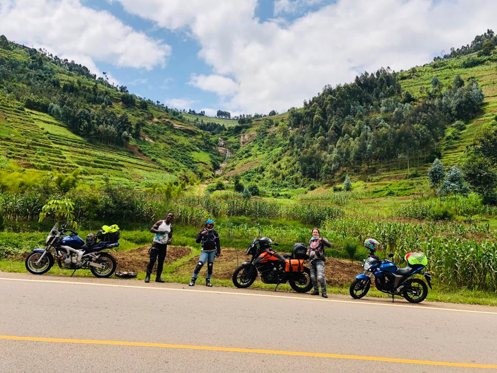
How’s riding in Rwanda? This pic says it all 🙂
After fueling in Huye, we continue towards Kigali.
We have a late lunch at Stafford (the other Stafford!) and it gets more busy as we approach Kigali.
On the last 20 or so kms on entering Kigali, we find some bad traffic built up. We move at snail pace down the hills between trucks. I remember a short cut that Tish and Chiri showed me last time. We find it and somehow manage the super sharp extra steep right turn without injuring any bikes in the process!
Google Maps does its thing leading us through side streets across a dozen hills and we arrive in Kigali at Havana’s friend’s place at dark. What a happy welcome by two happy dogs!
Next Day – New Year’s Eve in Kigali
It’s a holiday after all – the last day of the year! We review our 2022 and share aspirations and plans for 2023. Just yummy Indian food and dogs and girls catching up.
We head out to celebrate New Year’s Eve with some friends. A little dancing and beers. This city (well country!) is soooo organised, even the fireworks happen in a centralized place! 😃
Day 2 – The most eventful 1st January in history
We somehow make it to bed before 3am, knowing we have a guest to pick up in the morning at the border. Mbeche from our Nyumba Kumi is on his way to Kigali. He will join me for the Burundi-Tanzania leg of the trip. Yes, Burundi. That is the plan for today.
He somehow managed to reach Masaka in Uganda last night and gets up early to cover the remaining 300km to the Rwandan border Gatuna before breakfast.
We leave Kigali around 9 to meet him in Gatuna at 10am.
Havana will have to ride back home today! We plan to split up at Kigali, and meanwhile sandwich Mbeche who is new to riding on the correct side 👌 of the road.
Until I spot something interesting on the left side of the road: A suspension bridge crossing a small river.
Curiosity gets the better part of me, and we bid Havana goodbye, who has to cover a good 250km to get home.
Mbeche and I agree to have a late breakfast in Kigali, and plan out the route for today (go to Burundi? or directly to Tanzania?)
We get to Kigali just after noon and Maps navigates us to a restaurant that looks nice. Town is generally pretty deserted but a road near the Convention Center is closed. As I try another route, I get us lost, or rather we end up in a place that looks very official, with lots of flags and government offices in a large roundabout on a hilltop.
I stop briefly so I can figure out the directions on Maps until I think I know the way and continue moving. In my mirror I can see Mbeche not moving, but I’m not so concerned given he usually catches up fast. After two more turns I reach the restaurant, but no sign of him. A few minutes later I backtrack, just to find him stalled at the very place on the hill top, now with a Rwandan military official next to him.
His bike is not starting! We use our combined tools, brains and my internet to trouble shoot the error code (“crankshaft position sensor“). This might not be the best spot to repair a bike. Two civilians right outside the Ministry of Defence on a public holiday, one being an overly muscular black Kenyan wearing a camouflage balaclava + camel bak and heavy boots, the other one a white woman with a big orange motorbike. 😬
We just can’t figure out the error, remove and check different parts of the bike following various manuals from different websites we find. We assume the crankshaft positioning is fine, but the sensor throwing an error prevents the ECU from starting the bike.
No, we don’t take any photos. We are stressed!
A second and later third (equally armed) officer join the first one. We’ve taken over an hour here!
It’s around 3pm and Mbeche hasn’t eaten anything today. This year so to speak. The soldiers are a friendly type of watchful but really – we can’t overstay our visit at the gate of the Ministry of Defence, can we?
Rwandan bikers share phone numbers of their mechanics – but today being the 1st of January, we are requested to come visit the workshop tomorrow.
I offer to ride back to Havana’s friend’s place – first to ascertain how far and hilly it will be to reach there (this is Kigali, friends!), and also to ask her if we can stay another night. She’s very welcoming and laughs at our misadventure.
It’s not very far from where the bike is to her house, and gladly it’s mostly flat or downhill. We agree that we will somehow roll or push this 200kg piece of metal there. Struck by brilliance, Mbeche tries out jumpstarting the bike while it’s rolling down a hill. The Yamaha roars to life!
Shock on our faces. We repeat the same trick. Still works. Is it safe to ride to Tanzania now? After all the bike can be push started! We agree it’s worth seeing the fundi after all tomorrow.
We take an evening stroll around Kigali, and look for a place with a view and a drink. We can’t appreciate our host enough for providing us refuge!
Day 3 (well, 11 in total) – Not sure where we will reach today
We pushstart the bike to visit the recommended fundi Emme. He’s along some cobblestone roads up on a hill with narrow roads and a good number of mechanics and spare parts shops. Can you imagine a very clean, extremely organized and quiet Kirinyaga Road? Probably not, ey? Go see it: KN 130 Street
While the two get to work, I go look for breakfast next door (say, on Tom Mboya Street).
The mech is convinced that the crankshaft position sensor is fine. But the stator motor is not. It’s worn out. He brilliantly sources a Rav 4 spare from a shop nearby and solders it in place.
Success! The bike starts on the push of a button, as desired!
We look for Rwandan money to pay the mech’s dues – then head out towards Rwamagana and Eastern Rwanda. Burundi is not an option anymore and we decide to shorten the trip, heading to Tanzania directly.
But there’s one more thing I have to do before leaving Rwanda!
I spot Jackfruit on the road side! Fene! Fenesi!
As we park the bikes, the whole village turns up. We don’t seem to have a spoken language in common but sign language and smiles always work! The fruit is quite cheap and the market women pool their coins to hand me my change, as I tentatively hand over my 1,000 RWF note.
YUMMMM!!!
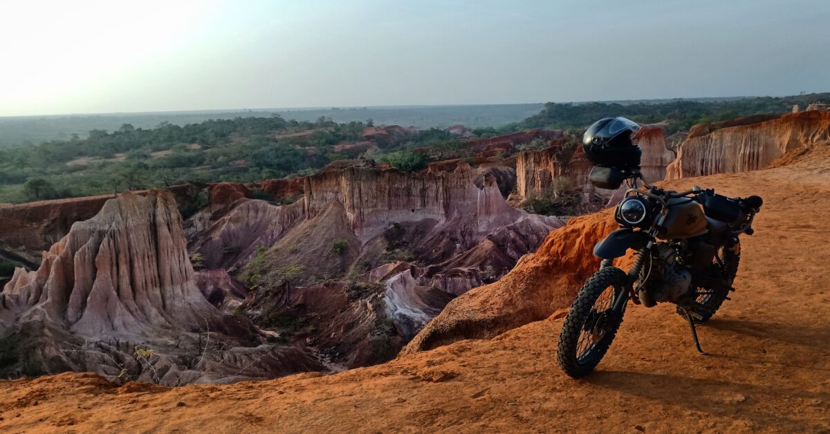
And how scenic the area is, with green hills and rock formations 😲
Within few hours from Kigali we reach Rusumo Border. It’s one of those One-Stop-Borders, where you ride to the other side first, then handle all aspects of leaving one and entering the other country in one building.
On riding through the 2km or so securely fenced border area, which is quite beautiful between hills and crossing the Rusumo river, I spot a bunch of military in the hedges. At some point three trucks are oncoming on my lane. Ooops. Time to return to the left side of the road!
Noone on this trip has asked me for my yellow fever certificate so far. But right here, on entering TZ, I realize I left mine in Nairobi, some 2,000 km away. The Port Health officer looks at me with those eyes. Luckily I’m able to retrieve it from my documents saved on the cloud using some very shaky Airtel mobile network.
When crossing a land border, the biggest horror is usually a bus load of 50+ humans in the immigrations queue before you. We somehow sneak through the door quicker than them! I had applied for and paid my visa online, so we clear Immigrations quite quickly.
On entering Tanzanian network, our phones switch an hour forward back to East African time. Procedures took a little longer, as both countries’ customs offices were keen to inspect the bikes before issuing the import/export permits.
By the time we finish the border crossing, it’s already sunset time.
Stunning. And as we stop for pics, a drunk guy runs after my bike, seemingly overexcited to sell me something, but he might have as well pushed me over. 🤯
In complete darkness, we navigate the next 20 or kilometers. The road has potholes and we nearly crash into some random closed barrier. Wow. A cruising speed of 50 will have to do this evening.
The area seems sparsely populated. We reach a small shopping center with various accomodation options, mostly aimed at truck drivers. Single rooms start at around 300 KES but we opt for slightly more comfortable accomodation (Prosper Lodge in Nyakasanza).
The universe loves us though! There’s a nice cafe offering buffet dinner and we add Chipsi Mayai as a dessert. It’s Mbeche’s first time in TZ so we’re having fun practicing our kiswahili sanifu with kaka-ing and omba-ing.
Day 4: Today we want to cover 630km up to Singida
The bikes are behaving well. Roads are wide and empty!
Just a few trucks and busses but we mostly smoke them. Today we learn that each village or shopping center has a speed limit of 50 km/h and most have a barrier at the end of it, manned by police.
The barriers are all open and we get into a good rhythm of speeding up and down, respecting our bikes just as much as the local residents.
Lots of cross winds today! My old bike was naked but light and less powerful, sometimes thrown away by wind easily. Natasha can confirm. The 390adv with lots of body surface feels more wind susceptible yet heavy and powerful enough. I don’t slow down really but still find it physically tiring to keep counter steering upwards of 110.
The Fazer or rather the owner doesn’t seem to notice the wind.
Beautiful Tanzania!
Our lunch consists of Chipsi Mayai and Soda. It is HOT in this January sun. Today’s topic of discussion is fuel quality. It’s a little cheaper but seems to run through the engines like water (figuratively speaking!). We haven’t seen any petrol station of a brand we know.
According to our maths, we have just about 1-2 hours remaining to our destination and we pull up at a place serving fresh juice.
We think we got a loooot of time to kill and hang out at the juice place stretching our backs. We can easily do the remaining 150km or so quickly, right?
We move swiftly until Mbeche suddenly stops. The Fazer randomly indicates a full tank. Oh wait, it’s not full tank. It’s a high temperature warning from the cooling system.
We hold a meeting to figure out the issue. A lot of coolant has disappeared from the cooling system! How? We refill it with water. How do you ride a 4 cylinder 600cc engine “carefully”? 🙈🙈🙈
The last hour into Singida is really pretty, approaching some mountains, then riding through them.
Somehow we make it to Singida town with the last sunlight and the Fazer intact. Lake Singida to our left.
We spot a Total petrol station! Quality Fuel with a 95 rating!
They don’t sell coolant, but point us to a second Total. A second Total!!
Kenyan Biker friends had recommended Amenity Paradise Hotel in Singida, and we pull up, with the manager who expects us providing a warm welcome.
There’s something about Tanzanian rice (yes, wali, mchele!) you can’t explain. It’s so fragrant and tasty! We order a full chicken kienyeji for dinner with some mchicha.
I’m too tired to even consider a beer 🤦🏼♀
Day? – Onwards to Arusha!
It’s the 5th day on this lag and my 13th day on this trip. The morning sees Mbeche changing the Fazer’s coolant. Cause Wueh!
We head out towards Lake Manyara by 11 or so.
It’s beautiful riding, no winds and I finally get to test the bike’s speed!
Of course we have to try out the local snacks. Y’all know Peanuts Karanga?
Then there’s this huge mountain coming up. Kili? Not really. Turns out to be Mt. Meru!
Approaching Arusha area, rain clouds gather
Sooooooo prreeeetttttyyyyy!!!
Arusha town welcomes us with bus-car-daladala-tuktuk-boda chaos. Slightly overwhelmed, I pull up at a petrol station where we filter Google Maps accomodation results by budget, make a few calls and take a pick. We end up at quite a forgetful guest house to be honest but clean. And the hot water worked, what else do you need?
I need cash, so we walk around town looking for an ATM. This is when we learn about Safaricom Global M-Pesa, where I end up withdrawing Tanzanian Shillings for less fees at a better rate through a Vodafone money agent than any bank has provided on this trip before!
Day 6 – Kiluletwa Springs and Kili – Vacationing in Moshi!
From Arusha, Moshi is not really far. We pass by another place with a memorable name. TZ just kills it with the names of towns!
About 20km off the highway lies a little gem I’ve been told about: Kikuletwa Springs, a community-run natural pool to chill and swim.
After some 20km rough roads, it feels GREAT to remove the sweaty gear and take a swim 💃🏻
Pure bliss! There’s even a swing. Little fish chew our feet and it feels like 2023 is off to an excellent start 💫
Kibandas provide different lunch options. The only thing missing is ice cream 😋
At last we pack up and climb the bikes. When we get back to the highway (really just a narrow two-way tarmac road), we are meant to turn right towards Moshi. I stop a few metres before the junction to buy some water. No kiosk sells water and I buy it at a bar at double the price.
We have half an hour to Moshi, and the gentleman volunteers to sweep. As I wait at the junction for traffic to clear so I can take my right turn, out of nowhere a skinny, middle-aged man runs towards my bike and switches it off. This is a tall bike and as usual, I’m holding it with one foot down only. I nearly drop the bike in the surprise moment. The guy tries to shove me off my bike. It’s extremely confusing cause it feels like daylight robbery! I’m not getting off the bike, so he tries to push the bike while I sit on it, but it’s in gear and can’t move. Finally, he removes the key.
A second guy, also in civilian clothes, with limited English comes to explain to me that I’m doing an illegal turn and I’m arrested 😬 🤣 🤬. A high volume, high speed conversation ensues between the two guys (Kanjo??) and Mbeche in Swahili.
I ask ask for their ID (none!) and insist the conversation happens in English, given I’m the aggrieved party. This throws off the two guys, and they have to call in their boss who speaks English.
We’re still in the middle of the road, what a scene! Bodas are watching but not getting involved. A friendly Tanzanian gentleman approaches us and enquires what the issue is. There is of course no signage whatsoever indicating that a right turn isn’t allowed and I explain the assault that took place. He convinces the guys that creating such a violent reception to tourists is not good for Tanzania’s brand and that if there is any fine to be paid, he will pay it for us. (Which there isn’t).
No, there are no photos.
We are released and take the correct detour to enter the highway.
On arrival in the guest house, we realize there’s no power in Moshi today.
We chill, review the pictures from the off-road swimming trip and replay the Kanjo scene in our minds. Too nuts!
Towards sunset, we walk through town looking for a restaurant and find a local place serving fish and rice.
Maybe it’s the long power cut that spoilt the fish. Or maybe we’re just exhausted and the beer didn’t go down well?
But we both get some serious food poisoning that night. I don’t get much sleep 🤢
Day 7: Recovery day in Moshi
We chew some dry toast, do laundry and clean the bikes. Around 3pm we finally feel strong enough to head out and explore the route behind Kilimanjaro.
Quite beautiful but we’re not enjoying it as much as the previous days’ riding. Rwanda and entering Tanzania from the West was just an incredible experience!
The riding at least aids the recovery of our appetite! We have dinner at a garden restaurant with glances at Kilimanjaro at sunset. What a chill evening to finish off an eventful few days 😁
From here, Mbeche returns to Nairobi as work calls. He receives a friendly escort from Namanga by bikers from our NK. I still have a week left, and will continue eastwards to the Usambara Mountains, with the aim of reaching the Indian Ocean and crossing over to Diani from there.
We really had fun! Not all two riders make good riding buddies!
What made these 1300 kms together smooth is an extra positive mindset, being accomodating to each other’s riding styles and an adventurous spirit. Plus the Fazer’s music turned heads in each village 😆
Y’all know the itch when there’s a route you want to try out?
What if it’s 1150km from home? When I rode to Rwanda in July, I missed seeing a small corner of Uganda, that I had heard so much about: The Kabale Kisoro twisties. 🖤💛❤️🖤💛❤️
There is also a very specific spot I wanted to go swim at near Moshi in Tanzania: Kikuletwa Springs. And a mountain to hike that a flower is named after that I remember from my childhood.
In short: East Africa was calling.
I acquired (and then lowered) a pre-loved KTM 390adv just a few weeks before Christmas. The new girl’s logbook came through last minute, so out we were!
A 3-week trip through 4 countries covering over 4,600 km – which I’ll share with you in 3 parts:
Part 1: Nairobi to Lake Kivu. Glances at Lake Bunyonyo, the Impenetrable Forest and a bunch of hair needle turns made me forget the rough Kisumu and Kampala Xmas traffic 😎☺️💯 Sunset at Lake Kivu should be on everyone’s bucket list 💙💙💛💚
Part 2: Kivu to Kili. Exploring beautiful roads with friends. Plus New Years in Kigali and a few bike repairs on the roadside
Part 3: Usambara Mountains to Diani and back to Nairobi. Hiking, swimming and relaxing!
Route looks fun, right?
Now here’s part 1!
PS: A detailed explanation of the border crossing procedure and requirements can be found in an earlier article here.
Part 1: Nairobi to Lake Kivu (3.5 days)
Maybe leaving Nairobi on Friday 23rd December at noon isn’t such a brilliant idea. But well. I set out westwards from Limuru down the Mai Mahiu route and aim to sleep in Busia.
All packed! What could possibly go wrong?
After circumventing some bad traffic down the escarpment, I head towards Narok and Sotik: Sweet empty roads! Some rains to bless the journey!
Just before Ahero, I find some mad traffic.
After kms of tight lane splitting, things get no better.
When the rain starts and some kadudu car gets stuck in front of me up a muddy hill, I decide to take a break.
The locals welcome me home and explain that I’m witnessing the Annual Migration – “they only visit once a year”.
I have dinner at the petrol station. The jam moves by 15 metres in those 90 minutes.
As night falls, I decide to just look for where to sleep. Magic! The petrol station has some rooms – with running water! And that’s how I only manage 320km today and sleep in Ahero 🙂
I’m up at 6am with a goal to sleep in Mbarara in Southern Uganda – some 600km away. But I find the same jam outside my window!
With day light, I’m able to navigate around the traffic easier.
Once past Kisumu town, roads are empty and I’m finally able to twist the throttle. When I rode here in July with Havana, I used my 125cc bike. I’ll one day write about this bike upgrade. Right now I enjoy averaging 100 km/h as opposed to 75 on empty roads – saves time and feels comfortable and safe!
After a triple banana breakfast in Luanda, I find looong queues at Busia border crossing. I’m not the only person trying to get to Uganda this Christmas!
It’s already 11:30am by the time I leave the Ugandan side towards Kampala. I stop for a late lunch at Java in Jinja, and it’s 3:20pm when I get to the Nile bridge in Jinja. I still know the route to the old bridge off-head and take some forbidden pics of the forbidden new bridge.
Riding through Mabira Forest Reserve, I witness a police pick-up car chasing down boda bodas carrying firewood that was evidently illegally logged from the forest. As one boda falls on the roadside at high speed, I wonder how the maths of poverty, climate change and conservation will work out over the next years.
Approaching Mukono the traffic gets really tight. It is indeed the 24th December, and people are travelling for Christmas! I’m already tired of lane splitting, going slow and tip toeing on the tall(er), heavy bike!
From Kireka I take the bypass, which is blissfully empty. What a spirited ride, with captivating views across the many hills of Kampala!
Once the bypass ends, the jam and the chaos starts again. I’m taking lessons in lane splitting from the bodas – we think bodas in Kenya do risky stunts, but please go see for yourself in Uganda!
Before long, the sun sets and I stop for pics at a petrol station. The askari approaches me and tells me I’m not allowed to take photos of the petrol station, nor my bike on the sidwalk next to the petrol station. So many beautiful things to experience in the Pearl of Africa – just don’t let such issues dampen your mood!
For safety I decide against pushing onwards to Masaka. I pull up at a hotel with good Google Maps ratings just after Kampala. It’s Christmas and they are offering massage and steam bath. Why not?
353km today!
Day 3 – Finally Open Roads!
Good morning! My goal is to ride the Kisoro twisties, then sleep in Kisoro, at the DRC border in Southwestern Uganda – which is 460km away.
I agree with myself over breakfast we’ll be minimizing photo stops.
At the Equator sign I have a very pleasant conversation with a Muslim family. It’s 25th December and I ask them where they’re travelling for the holiday. Big blunder. I’m informed that they are not on holiday because it’s Christmas and they’re not Christians. Semantics across cultures are always fascinating!
South the Equator, the road gets pretty empty. The rumble strips are just too many and at some point I have a sharp pain in my lower pelvis. I realized that the KTMs suspensions are great but maybe not great enough to protect my inner organs from being violently shaken, when lazily sitting on the bike. Henceforth I stand and bend at the rumble strips.
EDIT: A reader reached out and asked about this. So let me say a bit more: On this and earlier offroad-rides I’ve experienced random (i.e. not cycle related) cramps and even light bleeding when throttling over corrugations or bumpy patches repeatedly. Men may or may not experience this, because well, their organs in that area are different and any blood from light blood vessel tears may not necessarily come out (or would it?)
I’m really not the expert here, but I was taught at Offroad Adventures that the best way of avoiding riding related damage in organs (kidney, ovary, spine etc) is taking the following riding position: Bending forward (hinging forward, really) at the hip, therefore completely disconnecting the upper body from the rattling and shaking that the bike and lower body go through. Looks less cool than standing upright on your GS but gives you much better control of the bike, too (centre of gravity, elbows out, and all that). Happy to learn what others have experienced – leave a comment or reach out!
Before long I’m in Mbarara and take the Bypass towards Kabale.
It’s very pretty and I seem to have forgotten the issue of photo stops.
I’m just about to enter the twisties where we had our unfortunate accident half a year ago, when it starts raining heavily and I stop.
As I buy some water and chat with a shopkeeper and his daughter chilling under their roof, a local boda passes by with his christmas drink. It’s a kind of silly but very peaceful moment. I think of my friend who’s still recovering from his injuries he sustained near here. I also think about how unquenchable the thirst of adventure is.
The Kabale twisties are just so beautiful, despite the rain!
The trip counter shows 385km when I stop in Kabale for some samosas. I’m VERY excited about the route to Kisoro down the escarpment.
But first the road passes through beautiful hills, quiet villages and allows beautiful glances across Lake Bunyonyo
Oh boy! So pretty! We’re getting closer to the DRC and I pass a friendly military stop. And then I get to some steep hair pin turns.
I spot a cone in the distance, which turns out to be Muhabura Vulcano at the border with Rwanda. I’m in Gorilla territory now!
I get to Kisoro around 7pm, and Google Maps takes me through an adventurous rough road to my destination.
Dinner takes two hours to prepare, so I get to edit a helmet cam video. Enjoy a few twisty kms from this evening on this video link!
465km done today!
Day 4
Today I’ll enter Rwanda and ride along Lake Kivu. It’s only 180km from here to my friend’s place!
So first I want to explore Kisoro town! I also need to get some UGX from a bank because I ran out of cash due to spending an extra night in Uganda.
There’s quite a number of children and adults asking for money on the streets. We’re just a few kms and a (closed) border away from the DRC, where rebel groups are turning peoples’ lives into hell and making them flee their homes and land.
Being stared at and followed by people under the influence of alcohol makes me enjoy the walk through Kisoro town less and I head back to the hotel. I meet a Ugandan rider who’s attending to his bike and who’s planning to cross to Rwanda today, too. Around noon I head towards the border, very sure he’ll catch up with me.
Can you see these rumble strips? Nuts!
It’s a swift 15 minute twisty ride to the border town Kyanika – these corners are troublesome to trucks, as evidenced!
The border crossing at Cyanika takes much longer than expected. The Ugandan side is cleared in 5 minutes, but the Rwandan customs official takes at least 75 minutes to type my details into his system. More than enough time for the Honda NC 750 to catch up!
On entering Rwanda, we are welcomed by five speed cameras in quick succession. As he’s headed to Kigali, we part ways at the next major junction, and I have around 100km left for the day.
Once at the Gisenyi junction, I recognize different spots along the route and start missing my riding buddy Havana! Other than some brief drizzle, it’s beautiful, twisty riding along empty roads and relaxed villages.
The beautiful sight of Lake Kivu in the distance!
The speed limit of 60 is trickier to keep with the KTM than it was last time with the Spirit, y’all!
Entering my pal’s town Karongi with the last rays of sun!
Just in time for a breathtaking sunset over Lake Kivu!
And a huge fish for dinner 🙂
And here’s the best part of the trip: One of Havana’s BIG HUGS!
Happy Holidays and Merry Christmas, everyone! Wasn’t 2022 epic?
My month in Rwanda is coming to an end. Beautiful riding and new friendships. I enjoy Kigali’s bars and cafes with views across the many hills.
But Nairobi is calling.
I want to use the back route and explore Western Uganda, avoiding the main highway. I take leave and have around six days to get back home; covering around 1500km.
To be honest, I didn’t plan much. I just wanted to float.
How it ended up going:
Want to catch up on how I got to Rwanda? Here are the earlier episodes:
Nairobi to Lake Kivu (3.5 day ride) – article here
Lake Kivu & Ngungwe Forest & Rusizi border ride – article here
Now a solo return to Nairobi – using the scenic route!
Day 31: Leaving Kigali
That was fast. Or maybe I have just figured out the border procedure by now.
Remember to keep left – you’re back in Uganda now!
By the time I arrive in Kabale, it’s raining. The mountains North of Kabale are covered in thick clouds. I put on the rain gear and ride up North navigating the twisties carefully.
Quick photo stop at the arguably most important statue in East Africa. It gets hot again!
The road branching off left at Ntungamo towards Fort Portal does not look very inviting. It’s narrower and a bit pot-hole-ish and cloud towards Rwenzori Mountains are increasing. I’m torn. The whole point is adventure. Remembering the thousand rumble strips on the main highway and violent drivers, I turn left.
I spot some crater lakes on Maps and note it’s 79km to go. A little more than an hour without photo stops. I hit the road.
It never works without photo stops. And rain gear stops.
At some point I get to a roundabout. There’s a left and a right turn, but no straight. There is a Shell petrol station. The first one for a month, as there’s no Shell in Rwanda. I get excited for a minute. V-Power! Civilization!
Then it dawns on me that there should not be a roundabout on my 79km. And no T-Junction. Something is off. I pull out my phone and realize I didn’t press Start on Maps, and missed a right turn. I’m 30 rainy km off in the wrong direction. And how is it 3pm already?
Great. But there is a road up North which I decide to follow.
Until.
Yes, I can continue straight. Through 30km hilly offroad on a rainy day. Or not. I decide to backtrack to the junction I missed.
It’s 4pm now. And from here it gets PRETTY!!
At Ishaka the road from Mbarara joins us from the right. The whole area has very sensible tarmac and very little traffic.
I pass a bunch of crater lakes, each worth a visit and picnic. Then I pass some viewpoints and ride down into empty vast Savannah.
Queen Elizabeth National Park! A Ugandan biker had recommended Kazinga Camp but they are booked out. I find Tembo Lodge on Maps and ride in.
Even a welcoming (!?) hippo! I am given a sensible rate for room and dinner, and decide to spend the night here. But not before exploring the rough road into the National Park with the remaining sunlight.
It’s beautiful sunset riding, but sadly I get to the park gate within minutes. “Bikes are generally not allowed, but exceptions can be made.” Understandably, this is not an option at night…
The team at Tembo has three vegetarian dinner options. It’s yummy but the ten thousand lake flies make me flee to my room very fast after dinner.
Day 32: Rwenzori Mountain Range and Fort Portal
Tourism day! 114km to Fort Portal – all along the Rwenzori Mountains, maybe stealing glances at the glaciers and peaks above 5,000m.
If yesterday’s scenery and empty roads are anything to go by, today will be beautiful!
In Kasese town I get into a misunderstanding at the Total petrol station. I have to ride and get cash from an AMT, as my VISA card is not accepted. The attendant follows me closely on a boda so I don’t escape with the 5 litres of petrol.
It’s all very beautiful scenery and peaceful riding. I filter through Booking.com and pass by the recommended The Dutchess to check out the rooms and vybe. There’s a room with a shared bathroom within my budget, and I bump into the manager who gives me some tips to explore the area in the afternoon.
He’s not as enthusiastic about me riding to Ntoroko, a fishing village at Lake Albert, and mentions the UG-DRC border being more volatile and less hospitable due to smuggling activities. What looks like a cute peninsula along the lake according to him is an overgrown area, with no café or restaurant and is not a place to make friends – if at all I want to go there, I could ride to the UWA (the KWS equivalent) bandas, take a photo and return without talking to anyone to avoid trouble!
I’m of course tickled to do it anyways, but then he raises another idea: A hidden escarpment, with an offroad ride through some mountains to hot springs.
Now that sounds like a sensible afternoon!
I cannot wait to offload the luggage and head out!
Quickly leaving Fort Portal behind heading westwards
In the hostel there was a mention of an escarpment. But in no way did I expect to find this:
What heaven! It gets better with each corner. The tarmac is washed out in some spots by the rain, but it’s 99% great.
The valley is very beautiful too. Soon I’ll have to decide if I turn right towards Lake Albert or go straight to the Hot Springs.
Hot springs it is. Before long, the “old road” branches to the left. A chance to explore some off-road? I’ll take it.
There are some houses and farms. I stop to greet a boda who tells me I shouldn’t bother with the route. It’s steep. He and his passenger both fold their arms indicating a 45% gradient. I tell him I want to try it. He eyes my tires and says “Okay, but be careful.” But of course, yes!
It takes me a good hour for the 15kms over the Buranga Pass, mostly because I take a hundred photos in all angles. The map is thoroughly confusing. I can see the tarmac road directly below me but I’m at least 400m above it! How on earth will I get down? Just how steep will that squiggly road be?
It’s getting late, so I get to practice some of the cornering techniques Grace and her team showed me… and before long I get to the tarmac near the Hot Springs.
There’s a small river somewhere along this green space, it’s the border to DRC. In fact, at some point my phone roams on DRC network and adjusts the time backwards by an hour – confusion much!
I stop at the junction to the old road to buy some water and catch up with the bodas. My guy is also there and nods in acknowledgement. I now think he hasn’t been to that other side in a while.
The sunset across the valley is just the killer!
Usually you wait for the road to clear to take pictures. This place is deserted. So I wait for some minutes just to get some action on the cam!
Day 33: Fort Portal to Kampala
I don’t know what to expect. A Ugandan biker had suggested that I go via Hoima instead of taking the direct road. “The Government is constructing the road”. This would add 100km to my route to 400km total. I want to maximize the time in Kampala with my friend and her kids.
The first 30km are BEAUTIFUL! Smooth tarmac through tea plantations. Then it gets a little rough, but nothing too bad with the right playlist (Thank you, nani!)
Just around 100km into my day, I find there’s not much tarmac left around the potholes. You can imagine what cars and trucks do if they find crater-like potholes on their side of the road and there’s “only” a motorbike on the oncoming lane.
My plan to arrive in Kampala for lunch is out of reach, as I’m averaging 40/50 only.
And it gets worse as I get closer to construction. Or rather, the road was graded in anticipation for construction. It’s many kilometers of gravel with dust.
Finally, I pull up at the petrol station at Mityana. I’m covered in dust. The water I drink tastes dusty. The bike has a dust layer – which just looks horrible on a red shiny bike! My first attempt at a non-earth coloured bike – I might be too lazy for this in the long-run… I try to clean the helmet and visor without scratching it.
A white guy chats me up, who is caging and stayed in the same hostel in Fort Portal. The Shell staff can’t agree whether the road continues as bad or gets better from here.
It turns out to be better from here onwards and I reach Kampala by 3pm.
The roads in Western Uganda were fairly empty, much safer than the main highway through Masaka. Now it’s just a quick 20km dash on the Northern Bypass to my friend’s place. An overspeeding SUV overtakes me closely in my line while I overtake a slow truck. Completely and unnecessarily putting me at risk. There’s something about Ugandan roads that takes some adjusting.
My friend welcomes me warmly and we catch up on life over dinner! Steamed Matooke and G-Nut Sauce!
Day 35: Back to Kenya
How close to Nairobi can I get? It’s 650km!
I leave Kampala early with plans to have breakfast in Jinja and by miracle reach Nakuru today. Same route as five weeks ago!
After fuelling in Mukono, I head out Eastwards towards the forest. The roads are empty, and aside from some slow moving trucks I’m making good progress.
In Jinja, I want to try a local hipster looking breakfast joint I had scouted online (The Hangout Jinja). They unfortunately don’t allow me to park inside the compound and I don’t feel like parking on the road with my luggage strapped on the bike. I find my way to Java instead where the askari waves me to park next to his chair at the main door.
Around 10am I head out from Jinja with plans to reach Busia by 12.
As I pull up at the border in the same parking spot, the same cop stands guard. She asks me where my friend is. I admit that I left her behind somewhere in Rwanda. She must see a lot in this job, because she just nods. Border clearing is quite fast, but I cannot find my Safaricom SIM card anywhere. I had made a little paper envelope for it, which is torn. Damn it!
After navigating the horribly rough road welcoming people to Kenya, I spend 45 minutes at Busia’s Safaricom outlet to get the SIM card replaced. I have all kinds of currencies on me, but zero KES. You just never know. m-pesa is water and water is life.
From Busia to Luanda the road is empty. At the Shell in Luanda, the attendant asks me where my friend is. I admit that I left her behind somewhere in Congo. The guy looks at me with big eyes. Havana, we must have left quite an impression!
In Kisumu I ride through town, leaving the bump-infested bypass aside. It’s sunny and hot. It’s four days to elections and I expected campaigns but nothing much is going on.
Lunch!
From Ahero, I continue towards Muhoroni. Clouds are gathering over the mountains. I consider the Kericho route, but don’t see myself escaping the rain either way.
The rain starts in Koru and sunlight ends right after.
I have around 40km left to Londiani Junction. I meet a bunch of bikers who are heading westwards this Friday evening (for elections?). My gloves are soaked and Riftvalley August nights are chilly! At some point I stop on the road side and pull up booking.com on my phone and filter through the accommodation options. To reach Nakuru I’d have to use the highway and I wasn’t feeling it on a Friday night on wet roads.
I find a decent looking place and navigate there with my last 4% of battery. The road is a disaster, with a million potholes and deep trenches at the edges.
And this is how I find myself in Molo that night. Molo! Go figure!
The manager at Green Garden Lodge tells me to use a small connection road from Molo to the main highway, as the Molo road itself gets even more horrible up to Nakuru.
Day 36: Molo to Nairobi
In my wisdom I had packed one change of clothes in my small bag, and don’t need to repack the big bag that morning.
I leave before breakfast and navigate to the highway
I find the Molo stretch empty, the Gilgil area empty, the Delamere area empty. Miracles happen!
After breakfast in Naivasha the emptiness continues. It’s spooky. This highway is never this clear – and it’s 3 days to elections!
Well of course from Soko Mjinga it gets busier, but I travel behind a truck and all goes well.
Nevertheless, I am happy as I reach the Limuru swamp. There’s this little road safety statue on the left side, a completely destroyed car which aims to remind drivers to be careful.
And BOY did we have some bad encounters on this trip.
A total of 1530km since I left Kigali.
I am mesmerized from the beauty I saw in Western Uganda. I’d love to do it again and explore some of the valleys more, maybe hop over to DRC, though maybe with a faster bike.
I had religiously taken photos with the relieve app during the last 1200km of the trip. Around 80 or so pics. Now it turns out that the free version of relieve only allows 10 photos per video. So I activate the free trial of the paid version which only allows 50 photos. I end up removing many nice photos. What crap! I create and download the video and delete the app.
Whoever had a question about the Spirit’s top speed, here comes your answer!
Thank you Havana for inviting me on this incredible adventure and your friendship!
To the new friends made in Rwanda and Uganda, we shall soon ride together again.
To Paul, so many bikers and non-bikers have reached out to me and shared their recovery wishes.
Thanks to the bikers and WBA who have been so enthusiastic about putting together a first responder training with me, so that we can be well-prepared for the eventualities. For August we’re running a safety campaign, learning more about the many puzzle pieces of safety on two wheels. (Get the videos on IG under the hashtag #safetyWithWBA — link)
For my little virtual escort whatsapp group and everyone who kept checking in along the journey: Thanks for being available, for commenting on my photos and keeping me company even if you had mad FOMO in the office 🙂
Dear Reader, thanks for joining me on my first trip outside Kenya and hopefully not the last! Please comment on this post with more idea and experiences for great routes!
We have to extend our temporary bike import permits. They were only valid for two weeks. This can be done at any customs office of Rwanda Revenue Authority. Now, we’re around 100km in any direction from the next office.
We went North to Gisenyi last weekend (get the story here) and decide to go South to the Rusizi border for the paperwork.
We get up early and head out before 6am. The goal is to get to Nyungwe Forest for lunch, as we missed to see this famous forest last weekend.
It gets more beautiful by the minute!
Not everyone’s awake yet fully. At one of the many sunrise photo stops, a side stand is MIA and Mugabe goes back to sleep. His left eye comes off in the process.
I can’t figure out how to fit it back to the holder and we end up taping the lamp to the bike – at least the cable won’t get damaged by dangling along the hundreds of km we have ahead.
See how the road snails along the lake? Incredible riding!
There’s a long steep downhill and I’m riding behind one of those ninja cyclists who’s flying downhill at high speeds… I’m trying to keep up with him in the corners and my odo hits 72 as I spot the speed camera and let him go 🚲 💨 😂
After 90km of beautiful twisty riding we enter the RN6 highway that connects Butare to Rusizi/DRC
And then it gets really chilly and I instinctively know what comes next
Time for roadside breakfast overlooking tea plantations
Before long we descend back down to the Lake and enter Rusizi town. This is the Southern end of Lake Kivu and a river is separating Rwanda and the Democratic Republic of Congo here.
Within two minutes we arrive at the border point Pont I (There’s also a Pont II)
We park and look for the customs office. Upon presenting our objective, we’re informed that yes, it can be done here, but we will need to pay the fee in cash and only in USD. What on earth? How unexpected. All we have is MoMo.
We find a momo agent, a forex and get a sensible rate
From here the procedure has several steps, including showing our logbooks, a physical bike inspection, taking of photos, approvals, printing of a new permit and another approval step.
In short: a lot of waiting
.
Ladies and Gentlemen: The Congolese border has running water in the toilets – unlike Busia!!
Similar price: 200 RWF (20 bob) and I’m told “Il faut payer” – slightly more polite than “Lipa Kwanza” but same message.
We find out that the paperwork can only be extended by one month at a time. If you plan to use your foreign vehicle in Rwanda, you’ll be making regular trips to customs offices.
After around 90 minutes: Success! Our bike permits are extended and we pass by Emeraude Kivu Resort for coffee and ridiculous views across the lake, river and Bukavu town on the DRC side.
Next stop: Nyungwe Forest!
It’s about 60km to Uwinka Visitors’ Center and beautiful relaxing riding.
We enter a huge dense forest, the highway cuts right through it!
To enter the Canopy Walk we will have to wait for two hours, because there’s no guide available. 3pm? That should be our departure time if we want to get home with sunlight.
We decide that a selfie will have to do
They have a nice cafeteria built into the trees so we order drinks, then chill and enjoy the green views
Tish and Chiri join us for lunch.
It’s been two weeks since we rode together from Gatuna! Lots to catch up on.
No, I wasn’t the only one talking!
It takes the restaurant 90 minutes to prepare 4 burgers, so we head out quickly after lunch
And what an epic collection of bikes awaits us!
We have 115km to get back to Kibuye. There’s enough food in the fridge and room for guests – we invite the guys to join us at the lake house.
The forest is foresting. On departure we get rained on for 10 minutes and maneuver a loooong wet snakey downhill safely. At the turn back towards the lake we leave the clouds behind and the ride back is divine. The golden sun rays hit the mountains from the right angle!
Before long we get to the hair pin turn we saw in the morning. Breathtaking! Isn’t this the perfect place for a drone shot?
Tish rides ahead. Doesn’t the iPhone take good snaps?
Staying alert is becoming difficult. 290km of cornering is not a joke in terms of concentration!
We reach home just before sunset and goof around taking pictures
I’ve been drooling over the golden Transalp XL 700V over the last two weeks 🤤. I’m shy riding her but so excited that I can actually lift the bike while having one foot flat on the ground. One day 😇
A short sunset cruise around Kibuye town to top off the day.
The friendly soul who contributed an amazing reggae playlist to this beautiful evening: Barikiwe!
I know you’re all curious what happened. Well, there were beers involved, and stories and incredible kienyeji chicken. The muscly huge type that even has meat on the neck.
I can tell you about the morning, though. Because I wake up at 5:45 with the first sunrays, totally famished. I grab some chicken and enjoy the sunrise on the veranda. Then I go back to bed for two hours to catch up on sleep.
When I wake up the second time, the guys have whipped up an amazing breakfast. Next we sort out a few issues on our bikes including Mugabe’s left eye.
There is a general hangover in the air and we shelve the idea of riding each other’s bikes around town.
Before long, it’s goodbye, as the guys have at least 3 hours to arrive back to Kigali.
What a chill and beautiful weekend ride! 291km for us, and a total of 466km for the gents. And two speed tickets 🙈
PS: Curious about the return trip to Nairobi? I went through Western Uganda and it was breathtaking
PPS: There’s nothing like receiving July weather memes from Nairobi sitting under blue sky in the sunshine.
This month I’m working from my friend’s house at Lake Kivu. Over the weekends, we wish to explore the beauty of Western Rwanda together on two wheels!
Havana and I rode to Kibuye, Karongi district from Nairobi. You can read all about the 1373km trip through Uganda, incl. our preparations check-list on this earlier post.
Kibuye/Karongi town itself is rather quiet, and has a rural feeling to it. The main feature is the lake. It’s just sooo beautiful 😍
Some impressions of town:
The lake so awesome! One night we go for a sunset photo shoot.
And before long – Weekend 1 is here!
We plan to ride South to the famous Nyungwe Forest on Saturday morning, and ride through Butare back to Karongi. The return route will include an 80km off-road stretch. We decide to split it into two days and find a nice place to stay in Nyungwe Forest and make an advance booking.
The plan:
(Spoiler: It never happened like this…)
Two long days in the saddle again? We’re still suffering from the 3 long days on our bikes on the way here! We’ve been sleeping early to combat fatigue and be effective at work. One evening I decide to scavenge facebook for a massage place. We succeed and book two deep tissue massage therapy sessions for Saturday morning. They are back to back because there’s only one therapist, but by 11:30 we plan to be on the road!
Lovely place. Friendly team!
While Havana is having her treat(ment), I head out fuel the bike and then tighten the chain. It just takes 3 minutes and I was honestly too lazy during the week.
The chain situation
I pull out my spanners. I quickly realize that the chain cannot be adjusted further with typical means. The back axle is at its furthest point out. 😲 Kids assemble and watch me curiously while I think.
Havana shows up from her massage incredibly relaxed while I’m getting some advice from my friend in Nairobi about the chain issue. Can I find a fundi to remove a few links? Will it be tight on the back sprocket or is it just too worn out?
We agree that it’s not worth risking to head out like that and call our trusted local boda to point us to the right fundi.
He’s somewhere near the main bus park. Yes, that’s the main bus park of Karongi town. See your life!
Havana makes new friends while the fundi gets to work
We’re welcomed and the chain is out in 5 seconds
Fundi turns into dentist and knocks out two chain links
The old chain is stretched too much. It’s not sitting neatly on the sprockets whatsoever. This is not great!
There’s something I haven’t yet mentioned about Rwanda. The language is Kinyarwanda, which I don’t speak or understand. If you interact with the common man you gotta figure out how to communicate – remember that you’re the guest here! Some people speak some Swahili, others speak some English, and there’s also a bit of French (but my French is just too rusty).
Around my bike we have our trusted swahili speaking boda who doesn’t speak english, the fundi who speaks a little english but no swahili and around ten bystanders who speak in hushed Kinyarwanda to each other. We make the triangle communication work somehow and add in just enough pointing and sign language to cook up a plan.
There’s a new Chinese-made chain with the right specs (as per the manual!) available. It’s 10,000 RWF, approx 1150 bob. Our friend in Kigali calls his fundi but we can’t seem to find a Honda chain and sprockets in Kigali fast enough, so we go with this one. It fits like a glove!
Kinyarwahilinglish is a perfectly functioning language!
As I pay, the fundi tells me he is still new and has a lot to learn. I found his chain work sensible and encourage him to check out youtube videos but he lacks a smart phone.
We take selfies and bounce!
The Plan, version 2
It’s nearly 1pm, so we can’t do the original plan anymore. We agree to do a quick dash up the border town Gisenyi, close to Goma. It looks like an epic route with a million twisties!
We head out from the fundi and ride up the hill leaving town. In the first corner I realize that my back braking power is zero. At least I know what’s going on. My DIY mentor would be so proud of me. I stop to adjust the drum brake’s cable that is now totally loose given the back axle was moved all the way front.
Now we should be set! Let’s head out!
A final glance at the incredible view across Lake Kivu! Soon, the road moves away from the Lake and we ride through a mountain range. It’s just corner after corner for an hour. We get ino a good riding rhythm with some photo stops, happy smiles as we both bob our heads to our playlists.
There are deep trenches along the roadside. An amazing rain water management system along the slopes. Some good thinking was put into constructing these roads!! We get the purpose but it doesn’t make it less scary in corners…
Roads are fairly deserted but one thing that stands out are the well behaved mini buses ferrying people and goods from town to town. We also meet small children chilling out in the trenches and watching us curiously. Some jump on the road in excitement and wave. The speed limit makes sense after all!
The views!
It looks like it might rain. We’re trying to make mile but it’s also really cold suddenly, so I stop to put on my windproof rain jacket over my mesh jacket.
And then:
Are we in Karirana!? Wow! The last thing I expected were tea plantations. I start wondering what came first: the cold or the tea!
We should be close to Gisenyi now, and soon descent back down to the Lake!
Can you spot the Lake in the distance? We haven’t seen a lot of people on this afternoon’s route, but now the road is getting busier. Lots of people are walking. Many bicycles ferrying cargo and very few bodas.
We enter Gisenyi and cruise along the lake shore
Passing by a brewery!
We are at a few hundred metres away from Goma, Eastern DRC! How epic is this!? We HAVE to take a selfie at the border! I put the border post on my Google Maps and bluetooth guides us down a road until we reached a well-armed and closed barrier.
We are a bit puzzled. Are we even allowed to take photos here?
We watch some local women shout and scream at the unmoved soldier manning the barrier. The whole situation is not very inviting. A screenshot might need to do!
YESSS!
It’s 2 hours to darkness and we’re a thousand twists from home. But first things first: Lunch!
What an inviting sign post! We pull over and find a beautiful garden restaurant.
We’re served with the most yummy marinated grilled fish. By now Havana and I can read each other’s minds. Kwani, what’s the rush! Let’s sleep here and explore the town a little!
We get through a few local beers and a friend who happens to be in town joins us. I learn that Gisenyi is a party town and attracts weekend guests even all the way from Kigali!
Some people may or may not have gone to sleep while others may or may not have gone out to experience post-covid nightlife!
Sunday I wake up with renewed ambition to get a good border picture!
After breakfast we pack up and explore town a bit
Near La Corniche
We pass by the Rwandan side’s airstrip, which is literally across the border fence from the Goma airport. Just a reminder how weird this border business is!
We reach the border area and are a bit more courageous today. We ask the soldiers if we can enter and take photos. While one answers yes, the other answers no. “Don’t take photos of offices” is the conclusion. 👍 We park the bikes and take a stroll down past body scanners towards DRC.
We see cargo (diapers!) but not sure if it’s flowing east or westwards. One final conversation and we get permission for selfies at the final barrier!
Of course we get permision – because we’re glowing, happy, harmless tourists!
We’re excited! Why didn’t we carry our passports? We’d have hopped into Goma for lunch!
Next stop: The beach! We find a Serena hotel on Maps and decide to go for juice and to chill a bit more before riding back home.
It’s other-worldly. We are standing at a 5-star hotel’s beach in Western Rwanda staring at the water towards DRC. The news of the recent refugee crisis and the R23 rebel group’s strikes? We know of it. We can’t see it.
Expats are playing with their kids in the pool.
People are swimming, watching us curiously with heavy boots on their beach. Biker manenos 🏍️ 🤣
We chat over some fresh extra tasty juice and gear up to start our return journey.
I pretend to take photos of Havana but really: I’m just here for the colourful Kitenge clothes!
We’re going to be riding back the same route we came yesterday
Today we are more relaxed and well fed. The new chain is working and we know what to expect on the road: Corners, hill climbs, hairpin turns, long descents and views! 🐍🐍🐍
Exactly!
On one of those looooong winding roads I follow a bicycle loaded with gunias of produce. These people are fit!! They just push the bike plus load uphill. You won’t see many motorcycles as in Kenya or Uganda.
He’s doing a clean 50 downhill! Leaning into the corners with his heavy luggage on tiny bicycle tires. That’s real skill!! I’m very impressed and overtake him to stop and take his photo but as he shoots by me he’s too fast and I miss him 🤣🤣
Sometimes you see the road you passed a minute ago juuuuust across a valley
The road turns left, but you can see it re-appear on your far right
By the time we get back to Karongi we have graduated with a Masters degree in Lean Angle Management!
The Lake welcomes us home
We chill for the rest of our Sunday, intoxicated by our dopamines and endorphins!
Maybe next weekend we’ll make it to the famous Nyungwe Forest?
My biker pal’s job moved her to Lake Kivu in Western Rwanda. She had brought her clothes and favorite coffee mug with her by plane, but life was not complete. She was raving about the incredible roads, beautiful scenery and amazing riding once Mugabe would make it to Rwanda. Mugabe is Havana’s bike, a hoooot blue Gixxer 155.
We kept chatting as she settled into her new home, about the farmfresh food, the good air, beautiful lake views – and so we cooked up a plan to ride down together and for me to stay for some weeks before riding back to Nairobi.
How to prepare for such a trip?
Ages ago I lived in Uganda and had visited Rwanda several times, but riding there over a quick long weekend!?
Our preps included
Setting expectations. Two full blown adults spending 4 days or rather 3 weeks together. How would we ride safely together? Keep the mood upbeat considering it was going to be exhausting? Spend our days as we would both be working demanding kick-ass jobs, once in Rwanda?
Route planning: With 280cc combined, how would we split the 1300kms? Into how many days? Where to stay and eat lunch? What’s the climate/weather along the route? What are the heavy traffic areas/times, and how would we avoid riding into the night?
Paperwork planning: What’s needed to cross the border? Ride legally and safely outside Kenya?
What Google Maps says
Check-List for our East Africa roadtrip:
Must haves
First aid kit and skills
A trusted buddy to share our ICE details with and be our trip’s “virtual escort”. Esp if alone, share live trip updates so they can check up on you. Thanks to the one and only for offering to be on stand-by!
A waterproof document envelope thingy, because:
Passport/ID: We both didn’t need visas, but as a Kenyan resident I needed an interstate pass to avoid visa fees in UG+RW (print from eCitizen)
Logbook – which should be in your name. If bike is not in your name, take logbook and a letter from the owner outlining your travel itinerary to KRA in town before departure so they issue you a temporary permit. They will ask to stay with your logbook, but if you will cross another border on your journey, you can’t leave your original logbook with them of course. So just explain that and go with it.
Valid driver’s license
COMESA insurance for the bike. This is an extension of your normal bike insurance, so has to come from the same company
Yellow fever vaccination certificate
Covid travel requirements – at the time we travelled, a vaccination certificate was enough to cross the land borders. This may vary! We still took a rapid test to be sure.
4 copies of everything, as you will leave copies at each border.
There are no payments at the border. Unless you want to tip a broker to help you figure out where to queue (which really isn’t needed)
A pen to fill in the immigration form.
Enough cash for fuel, accomodation, eventualities. Do not rely on your bank card or mpesa to work. We carried USD (in fresh 20$ notes from a forex bureau) and KES. I couldn’t find RWF in Nairobi and the UGX rate I was offered in forex bureaus was crap, therefore opted to exchange at the border. Knowing the official exchange rate can help you negotiate.
Know the country’s road rules. e.g. TZ and RW have speed limits! What do yellow or white lines mean? etc
ATGATT – don’t go easy on that just because the roads are less busy or it’s hotter than home.
A clear, free mind: Safety mindset, defensive riding 101%
Check if your private health cover will sort you beyond Kenya. Get details on how it would work and phone numbers
Bike tools, serviced bike incl. a thorough bolt, chain and bearings check
Important stuff
An evacuation cover. What if you crash and there’s no good hospital around? How will you reach home in your injured state? Check out e.g. AMREF Maisha cover (link) It’s a good idea even in Kenya, but the cover for neighboring countries is slightly more so you might need to upgrade if you have one.
Data bundle. To create FOMO inducing insta posts, update your trip buddies, call your fundi on whatsapp, etc. Roaming on another country’s network with your SIM card can be expensive. You could rely on wifi in the hotels, but how will you deal with an emergency? I bought the Airtel One Africa bundle for 1100 KES for 10GB which covers UG, RW and 10+ more countries. It worked magic: A seamless online experience.
Enough airtime on Safaricom to make emergency calls. Airtel network might be low in some places. Safaricom tends to roam on the stronger networks.
Power bank. Adapter for Rwanda-shape sockets
Nice to haves:
Look up accommodation options in advance to avoid looking for places late at night. Go through the reviews at the comfort of your home. We made bookings on booking.com. Some hotels allow reservations without upfront payment or entering card details. Or get their numbers from Google Maps and make a booking via whatsapp. It tends to help if someone expects you at night in a foreign land (we will come back to this later :-S )
Emergency contacts of bikers on ground in case you need assistance. You might be a loner and don’t want to mingle. Fine. But at least get a number and let them know you’re visiting. Or you might make a dozen new friends and have the cultural immersion of your lifetime!
TP, wet wipes, musli bars, basic meds like pain killers…
and so on…
Soooooo, how does the border crossing work?
The border procedure has two aspects and you have to clear them with both countries. Once you understand the logic and are confident you have all papers, you will not worry much about needing an agent/fixer to help you at the border.
1) Immigrations for yourself (ID/passport, yellow fever vaccination certificate, covid vaccination/test certificate, they’ll take your fingerprints and photo)
2) Customs for your bike (Logbook and copy. Copy of ID/passport. All copies will stay with them. They will register you in their system and issue you a temporary permit to take the bike into their country. They might counter check the chassis and engine numbers, so know where these are on your bike.)
3) To ride legally, you need a COMESA insurance cover for your bike and of course a valid DL. You probably don’t need to show these at the border but at police stops.
So much for the preps! It’s a full-time job in itself!
Here’s our story of riding to Lake Kivu 🙂
Day 0 – Head start to Naivasha
We wanted to reach Jinja on our first day. And we wanted to reach before sunset. This was going to be an overly ambitious ride from Nairobi, and with our “small bikes” we would need to leave around 4am – in full darkness and with July cold.
A biker friend was willing to host us in Naivasha for the night, so we left Nairobi on Friday at 4pm. Quick viewpoint stop and hot drinks at EsQoffee.
We are soooo ready!!!
I want to say it was an uneventful ride down to Naivasha, but we meet a few naughty drivers on the road. Once in Naivasha, we pick up pizza and proceed to my pal’s house where we have chats over dinner. We debate the best route (Eldoret? Kericho? Londiani?) and settle with Londiani, with some uncertainty of where we’d find a great breakfast along that route. After a hot shower we set our alarms to 5am and sleep early, dreaming of the next 1200km and two border crossings.
Day 1 – Naivasha to Jinja
We head out from South Lake Road by 5:45am and enter the Nakuru highway with the first sun rays. Our ride through Gilgil is freezing but we’re making good speeds and before long the dual carriageway welcomes us to Nakuru.
Sun is up – Nakuru at 7:10am
After a fuel, water and toilet break we head out towards Londiani. There’s a rather narrow uphill section with lots of tree twigs indicating broken down trucks. We count at least four (or were they just parked!?). I had replaced my front tire just before this trip but the grip is great so far.
Google Maps maneuvers us off the highway towards Londiani junction and from here it is a breathtaking journey. We start to feel our empty stomachs but can’t spot any breakfast places. Even the few kibandas look closed!
These three beauties!!!
Then we spot a signpost on the left: Koru Country Club. It’s a petrol station with choma and what looks like a restaurant! We enter and park the bikes. Many sets of eyes on us as we climb off the bikes and celebrate our progress so far! 198km in 3.5 hours! Not bad 🙂 Fresh Juice, and a hearty breakfast.
10am. 305km to go.
Next stop Kisumu, we agree.
We pass through sugarcane fields and that smell near Muhuroni’s sugar factory can wean you off sugar, I want to believe.
This is not a stop. It’s just a photo break
On approaching Kisumu town, I spot the signposts indicating the bypass. Google Maps on my bluetooth is quiet. Maybe I forgot to click “start” and going straight will get us into a huge traffic jam in town? I turn and take the bypass. Big mistake! The bypass has over 20 huuuuuge, steep and violent speed bumps. It’s not just annoying to ride over but we’re also slowed down by the trucks as they navigate the bypass at snail pace.
We finally get to the airport and stop for pictures, high fiving ourselves for the progress. Havana is just toooo nice. I would have been pissed with the lead for that choice of route, yo!
From Kisumu it’s another 110km to the border. With our late breakfast, we say let’s push through and eat at Busia. We run into lots of slow trucks on a narrow uphill towards Maseno. Once past Luanda, the road is empty. Until we find ourselves in the middle of a political rally in a small town. A good hundred bodas and maaaaany people are standing/walking on the road. They are going in our direction but still – we could get stuck in the middle. I signal to Havana whether we want to stop and wait this out, but we somehow manage to squeeze through.
Before long we enter Busia town. Trucks are lining up along the roadside waiting to enter the border area. A guy starts running next to my bike speaking with me for a good 600m. I’m listening to music in my helmet but figure that he’s one of the agents that wants to help you with border clearing for some cash. We had agreed not to use one, so I keep riding and we enter the huge border parking lot. I ask an askari where to park, and the agent answers. I tell him we won’t use his services politely. He keeps running next to my bike.
Once parked at the border office, I tell him off less politely and we ask a Kenyan police officer for where to start and she points us to the KRA counter.
After processing our papers on the Kenyan side, we proceed to the Ugandan side. The only negative experience is the toilet. I arrive there with swaths of women who just got off a long busride, clearly pressed. We all get yelled at that we should not even consider using the toilets without payment. In short “Lipa Kwanza! Ni nini!”. I mean, woooow.
Uganda side immigrationsSelfies after exchanging money at a pretty sensible rate with some guys walking around with huge bundles of notes. They wear coats with numbers and seem registered.
We roll into the UG side of Busia. Total one hour and 15 minutes 🇰🇪 -> 🇺🇬 . It looks the same. Until we see the Shell petrol station. 6180 UGX per litre. That’s 195 bob! We consider turning back just to fuel in Kenya @ 160. Well, not really, coz small bikes don’t mind such issues toooo much.
We look for lunch!!
Steamed matoke, skuma wiki and beef stew at a Kibanda. 6,000 UGX is around 200 bob.
I switch mobile data from Safaricom to Airtel. My Airtel Africa bundle works perfectly.
Excitement! We are in Uganda. Smooth border crossing! 117km left. We had been told there might be some construction along the highway. We leave Busia at 4pm with optimism we’ll make it to Jinja by sunset.
I’m entering honeymoon state. Few cars. No drama. There’s one diversion for bridge construction but it’s short and fairly painfree. We’re riding through open green fields and it’s nice riding. A mix of Kenyan and Ugandan number plates.
Around 60 km in a probox kinda car approaches me from behind. I’m following a line of cars, there’s oncoming traffic and we’re all going at around 80km/h. In short, there’s nowhere the car is going. He comes reeaaall close to my number plate and starts flashing his light. I ignore him but start scanning the side of the road for an escape route. There is a narrow gravelly path before a deep ditch – it’s a 15cm step down from the highway. This is when the big boys show the car dust, but what to do? At some point he disappears from my mirror. Not a good sign. He has entered my blind spots and is right next to me. A hand can fit between my and his mirror, but not more. He basically pushes me to the side and I carefully ride down onto that ditch-y path to avoid being hit. What an asshole. He and his passengers even have the guts to open all their windows and gesticulate that I should be riding “down there”. I stop the bike for a few seconds and breathe. After letting a few cars pass, I get back on the road. As fate has it, the cars are building up at an uphill, and I overtake all cars including my friend. I avoid seeking eye contact. We know how this could end.
Honeymoon ends abruptly. By the time we get to Jinja, I have another 2-3 cars pointing me down to that “side lane”.
Ignoring all emotions, we continue riding safely and before long enter Jinja town. By now it’s beautiful evening twilight. We still have time to ride down to Lake Victoria!! A quick Maps check tells us there’s a road along the shores of the lake and we can ride back up towards along the Nile.
We hit the road and find tarmac ending soon.
We get a bit unhinged and follow a steep single track down to the water.
Mugabe does well in his tarmac shoes!
We find this railway bridge across the Nile. Lots of people walking and bodas cruising on the walkway under it, as we look for a the best photo angle
Aaaaahhhh!!!
After saying hi to various local riders, we ride back up to the tarmac.
Jinja roads are fairly deserted. As we cruise around to get a vibe of the city….. well and find our hostel
We check in at Jinja BaseCamp for the night. We didn’t pick it based on rating/recommendation but because it was the only accomodation within our price range where we could make a booking online without card details. The team was welcoming, there was free drinking water. The room was not exactly spacious, but we only needed to shower and sleep. The manager was so kind to help us order dinner in from a restaurant.
Imagine, we finished it all!
We inform our people of our arrival. 517km done! Smooth border crossing. Sunset pics at the Nile.
What else do you want?
Day 2 – Jinja to Kabale
We wake up early, pack up and load the bikes. We’re out of the gate by 5:30am because the goal is to have breakfast in Kampala – a quick 82km away – and be out of the city before the Sunday traffic locks us down. But first we look for fuel in Jinja. There are two Shell petrol stations, both still closed, so we end up at a no-name pump.
Various Ugandan bikers had informed us that motorbikes are not allowed to use the main bridge over the Nile and we didn’t find it worth the risk of being arrested. I chat up a car driver and ask him about the route to “the other bridge”. He is visibly confused that bikes are not allowed to use the main bridge. His passenger even challenges me to use the bridge and see if I’m being denied entry. On seeing the passenger’s white police uniform, I decide to withdraw from the conversation and that Google Maps will serve us just fine. But the driver ends up talking to a boda guy to take us across the bridge.
And off we go through a dingy, dark, muddy rough road 🙄 . The sh*t bikers go through, I tell you!! In the end we arrive and ride over an older but functioning bridge and on the other side I tip the boda.
From here we finya the bikes out of Jinja. We really want to get to Kampala before the city wakes up! But first we have to cross Mabira Forest at night. It’s pretty chilly and I follow a Noah who lights the way for us. He doesn’t seem exactly sure of the road, which works for us as we average 70 on the bumpy road through the dark forest. At some point I realized it’s a KCN number plate. The guy is equally new here like us 😉
Once through the forest, the sun risesWe ride through misty hillsThere’s always time for selfies!
We ride through Mukono and I marvel at how the place has developed. Obviously – it has been 10 years since I last visited!
We get to Kireka and have the choice of going straight through town or turning left to take the bypass.
Remember what a bad idea it was in Kisumu to take the bypass? It’s Sunday 7:15am so we decide to cruise through town. Within a few minutes we pass Banda and take the Lugogo turn, then Upper Kololo Terrace past the airstrip with a few glances over town. Empty roads and I’m so thrilled to be riding in Kampala. This is where I started my biking career back in 2010: as a boda passenger.
Within a few minutes we park outside CJs and enter for breakfast. Havana’s friend joins, and a few members of Uganda Bikers Club as well. We have a great time. It just feels wonderful to know you’re part of an East African community of like-minded people. They even offer to escort us towards the southern side of the city although they are heading out the other direction for a CSR ride for Rhino conservation!
On leaving the restaurant, we find traffic bumper to bumper.
Our hosts take us through busy city roundabouts, where at some point a boda falls right in front of my front tire. His two passengers quickly pick up their many little boxes and abandon him to pick up his bike. We get to the Northern bypass and our escorts wave us goodbye at the final turning.
The next 66k takes us ages for some reason. Or maybe it just feels slow. Up and down on a very straight road with a small engine can feel like that.
Stop to change the playlist. Maybe that will help!
By the time we get to the Equator sign, we wonder if the day will ever end. 11am and only 160km done! 343km to go to Kabale all the way down near the Rwandan border!
We continue towards Masaka, then Mbarara. I can’t say that I enjoyed this part of the ride. Soooo many rumble strips. I remind myself how to stand on the bike hinged forward at the hip, disconnecting the upper body from my legs. I learned this in a recent offroad training: You want to avoid that these violent vibrations affect your inner organs.
Louder for the people at the back!
At some point we ride through a very long swamp. Dried and fresh fish is being sold along the roadside. I’m curious and stop but the language barrier prevents any conversation.
Then I see a bus approaching from behind. It’s an open empty road. I’m doing 85 so he’s easily doing 100. I’m used to busses in Kenya overtaking me closely, at least halfway in my lane. The opposite lane is EMPTY and he has at least 800m open visibility to overtake smoothly. But this guy doesn’t move to the other lane by even a single inch.
At some point he’s just a few metres behind me. Seemingly happy to roll over me. I move off the road. In the next town find him at a speed bump. Of course. Overtake or not? Obviously some drivers get pissed by this, thinking you’re challenging them while you really just want to get to your destination. I let him go.
As if this wasn’t crazy enough: A bit later, again on open empty roads, an oncoming car pulls over from his side of the road to drive towards me in my line, looking directly at my face.
My conclusion at this point is that while Uganda might have less traffic and fewer careless drivers, there is a special breed purposefully putting you at danger.
We find more and more rumble strips and it gets hot. We take another water break and make it to the lunch place just before Mbarara by 2:30pm, an hour behind the plan. We find two bikes in the parking lot. Our escorts from Rwanda made it here before us!
A beautiful golden (!) Transalp and a Suzuki DR 650 😋
Get-to-knows and conversations over lunch. Two experienced riders had come for us all the way from Kigali – crossing the border just to welcome us. Wow! One had a pillion, a female motorcycling enthusiast who is just getting into riding.
Have you noticed that when adenture riders come together, it’s always story o’clock? Who knows who, who has been riding with whom to where? How did you get into riding and which of all your bikes was your favourite? Which was your best mechanic and what blunder made you divorce him?
We share about our ride so far. Havana and I can’t belive how much has happened on this trip already. It is just yesterday that we left Naivasha! And now we’re having lunch in the South-West of Uganda!
All Foods with G-Nut Sauce! I had missed this 🙂Pic before departure with the Ugandan cranes
By 4pm we get on the road. 155km to go. We clarify that our engines are a bit smaller and we all look forward to a chill ride.
Once past Mbarara, it’s bikers’ paradise! Light twists, a wide new highway with gentle speed bumps. The scenery! This must be East Africa’s best kept riding secret!
I keep stopping for pictures and the lead with his pillion has to keep turning to look for us. But boy, it’s so beautiful! It’s a wide empty highway and we adjust the riding formation slightly every now and then.
We’re around 40km from Kabale town, our destination for the night, when the road gets steeper and twistier. My bike struggles a bit with speed up the hills and thankfully there’s a climbing lane. But there’s a certain red bus that doesn’t like the idea of four bikes being on the road. He overtakes us very carelessly, just for us to find him at the next town’s bus stop alighting passengers. I don’t have a great feeling overtaking him, but we really want to make mile and get to Kabale before dark. The guys still need to ride back all the way to Kigali today!
Viewer discretion warning: If you are not comfortable reading about an accident, consider skipping to Day 3 now.
On a long winding downhill, we’re doing 80 or so and the bus rushes by Havana and me carelessly again. I’m riding in second position and suddenly everything happens very fast. The next thing I see is Paul separated from his bike, both lying on the tarmac. The three of us stop our bikes. As we run to him, my accident response theory spools off in my head “Secure the accident scene. Provide first aid. Arrange medical help.”
Havana and I get into first responder mode, speaking to him, helping him remove his helmet. I look at his leg. Something is not right with the angle of his ankle. There is a bleeding wound. I remember a first responder video I watched a few weeks ago: I kneel into his artery at the thigh and use my shawl to tie his leg – in a bid to stop the bleeding.
Meanwhile, Tish and Stella secure the accident scene. We’re in the left lane of the road, but we don’t want to move to the side before we have a better grasp of the injuries. Villagers assemble and help put twigs on the road and wave down traffic. This being a hilly area, network is on and off. We make a few phone calls to Nairobi and Kigali to get advice. Paul is in pain and needs qualified medical attention. We are 20km from Kabale town. After a few minutes, a car stops and agrees to take the injured to the hospital. The first good Samaritan today! A few men help him into the car and Stella goes with him, Tish riding behind the car. We agree that us girls would stay behind to wait for the police.
It’s getting dark now. We look for the car that was involved in the accident and speak to the driver and his passengers to hear if they are injured, which thankfully they are not. We take lots of photos and wait for the police.
A guy in tshirt and jeans walks past, taking photos of me standing next to the three bikes. I ask him who he is. He smiles. I ask him to delete the photos. At this point I can only think about Paul’s ankle and I don’t find it appropriate for our photos and that of an accident scene to be in people’s phones. He laughs and walks away. Surely!
When someone tells you the police is coming, you wait for a police car or a uniformed individual. Or maybe that’s just me.
It’s taking a bit of time for said police to arrive. We’re still standing next to the bikes on the road side and catch our breath to calm down our adrenaline rush. We look for some water and wet wipes to clean up. A villager suggests moving the bikes to avoid further accidents. We count our belongings and ensure we have all bike keys.
And suddenly another man and a lady walk up to us. He takes photos of us, the bikes and they walk up to the other vehicle. By now I was a bit tired of the unsolicitated photography. I asked him who he is and why he’s taking photos. He states being a police officer. I stare at him in disbelief and say it’s been few strangers taking our photos and whether he has any ID. He says he’s from church pointing to his clothing, and so he didn’t carry ID. I say something that might not be very polite to repeat in writing.
The issue is cleared up, when another car driver stops and offers to help. I request him to call the police as we’ve been waiting for nearly an hour. He makes a phone call that is answered by the kitenge-dressed gentleman. 👀
After a quick assessment of the scene they suggest that it’s safest for us to ride to Kabale town. They explain that they’ll take possession of the bike and car and we can go to the police station the next morning to file our statement. The police officer goes on to say we were lucky that our helmets or belongings were not flossed from the bikes while we were distracted.
We carefully ride through the twisties in complete darkness and our LED lights are really coming through for us. Once in town, we ask for directions to the hospital.
On entering A&E, we catch up with our friends. The wound is bandaged and pain killers are administered, but no doctor, surgeon or nurse is available to look into the cause of bleeding or run relevant tests. Some plain-clothed individuals walk around and watch us curiously. The lady at the desk is glued to her chair. We quickly realize that the hospital is not staffed or equipped to deal with this type of injury.
But how do we transport an injured person across a country border? We need excellent healthcare real fast. I call AMREF to find out about the procedure and cost of air evacuation to Nairobi. They are willing to pick him with an air ambulance incl. doctor with the first sunlight from a nearby airstrip after payment of 16,120 USD.
Meanwhile calls to Kigali are made and someone offers to arrange dispatch of an ambulance to pick Paul at the border. And this is when I get a WhatsApp mesage from the manager of the lodge we were meant to stay at “Are you still coming tonight?” – I tell him we had an accident and he immediately comes to the hospital with his friend and two cars.
We see that the two wounds are bleeding again. Unfortunately there is no staff in this hospital who are able to help us. We use bandages and two techniques to control the bleeding: Applying direct pressure and tieing two tourniquets (Google it, I’m also posting a video below the post!). We get phone advice from a doctor friend on managing a 3-4 hour drive to Kigali. This is our best option. The car has a logbook and we estimate that if they leave now, they will meet the ambulance somewhere between the border and Kigali.
And so the patient enters a second car. One bike will ride behind the car to speed up the border process. After all he wouldn’t be able to queue at the counters. Us girls are staying to handle the police case in the morning.
On leaving the hospital we wonder whether it’s sensible to still ride down to Lake Bunyonyi to the place we were booked at. It would be nice to at least see the lake – plus how would we find a safe hotel in this sleepy town at 9pm?
The hotel manager drives ahead of us, until we get to the turn-off the tarmac. 9km offroad he says. “Not too bad”. I take the lead and before long we find ourselves on a bumpy, dusty, steep road. I can’t see very well because of dust but this feels like fesh fesh! What the heck.
Then we descent down to the Lake. We can’t see much but it’s a winding road along cliffy edges. I just hope that Havana behind me see the edges, too!
Once at Bunyoni View Resort, the team wips us up a very late dinner. What angels! There’s a power cut and our phones are nearly dying. We chat to stay awake until we get an update from Kigali. We discuss our experience at the hospital and reflect on our medical response knowledge. Around midnight we hear that they arrived at Kigali’s hospital.
We thank God for the miracle and go to bed.
While we are tired from the long day and the 503km in the saddle, we don’t get much sleep this night. The emotions from the day are still settling.
Day 3 – Kabale (Southern Uganda) to Kibuye (Lake Kivu, Rwanda)
We wake up early to birds chirping and breath taking views across Lake Bunyonyi. Update from Kigali is that the first medical procedure was successful. We snack a musli bar enjoying the good news and morning sun on our balcony. Then we pack up and load the bikes. While charging our phone and having breakfast, we return a few more phone calls and ascertain worried bikers in Nairobi who got word overnight that our mutual friend is doing well and in the best hands.
The lodge’s manager shares some tips about the police procedure. We are grateful for his support as we do not know what to expect in another country, but it sounds similar to realities in Kenya.
The ride back to town. What beauty!!Passing by a quarry – explains the fesh fesh like dust last night!
We proceed to Kabale Traffic Police to file our statement and leave some required documents. It is a really smooth experience, with the OC expecting us and explaining us the process from A to Z. I am very impressed with the professionalism we meet in that office.
En route to Gatuna border
We continue to the Gatuna border around 1pm.
The border crossing is smooth 🇺🇬 -> 🇷🇼 and within an hour we meet two bikers who have come for us all the way from Kigali. We are really grateful to see them, these guys truly know how to be amazing hosts!
The excitement to ride on the right side of the road!!! I had been waiting for this for months. From here it is twists, smooth tarmac, more twists and empty roads. The Kigali bikers show us how to spot the automatic speed cameras. I am not exactly tempted to push beyond 60 much. Most Kenyan friends on whatsapp chats are shocked to hear about the 60 km/h speed limit. Blame the 125cc or my fatigue if you must, but the twists and amazing scenery are enough to enjoy this ride at leisurely pace.
Speed camera – your fine comes via SMS – fully automated!Water break goofing around with bodas
At some point our pal says “from here it’s all downhill to Kigali” – wueh the next hour was one of the best rides of my life 🤯 🏍️ 🏂
Once in Kigali, lane splitting and weaving through bodas needed full concentration to stick to the correct side of the road 🤣
This golden Transalp 🤤 🤤 🤤
After goodbyes to our friends in Chigali, we continue towards Western Rwanda, the shores of Lake Kivu. But first we have to get out of town.
There’s quite a number of steep uphills and we are stuck behind black exhaust coughing trucks going at snail pace. Imagine just how tempting it is to overtake then seeing a continuous yellow line and noticing a dozen local cars NOT overtaking! Can never happen in Kenya 😤Well, we aren’t planning on getting arrested today! So we get serious clutch balancing practice and enjoy the fact that no-one overtakes us in a dangerous way or cuts us off… Finally, we see our chosen lunch restaurant on our right!
It’s 4:45pm as we gear up after lunch: an beautiful extremely twisty 120km up and down hills are awaiting us. Zeeerrooo speed bumps! Less than 5 cars on the last two hours!
There were some 40km with bad tarmac and lots of sandy potholes but we took it in a stride.
You know the sunset riding paradox, right? When you are seriously running out of sunlight but keep stopping for photos!
We squeeeeeze that twilight to at least make it past the bumpy stretches.
After unforgettable sunset views across the mountains, we still have another one hour of darkness. The roads are now smooth and the road demarcations are painted using reflective paint, which makes it so much easier. Can the GoR please share their procurement contact with GoK? Beautiful cruising!! The twists, a random unlit bicycle or villager walking on the road makes us restrict ourselves to 50/60.
As we get to Karongi/Kibuye town, Havana takes the lead to her house. I see her seriously cutting the corners, knee downs and all. Shock on me! I mean she knows her town but really! Was I thaaaat slow all day? Isn’t this a bit risky!?
There’s a point we ride along the waters of Lake Kivu glistering through palm trees. Oh my!!🌴
A few more turns – and we enter the gate.
How do you park a bike after 1373km?? Should they not be sleeping inside?
We check in with our people in Nairobi, Kigali and Kampala. We’re relieved to hear that the healthcare at King Faizal hospital is working like clockwork for our friend: scans, first procedure to clean the wounds, blood, preparations for surgery etc. We celebrate all the things we did well on this trip and reflect on the journey and many encounters.
Already feeling at home!
And this is how we rode to Lake Kivu from Nairobi in under four days.
With an unstoppable appetite for life and adventure, years of riding wisdom gathered on the road and leaning on each other and the East African riding community.
The next day is a work day for me. As I boot my laptop in the morning to catch up with my various clients and projects, I overlook Lake Kivu and realize just how much beauty we have in East Africa.
In the evening we take a sunset cruise around the lake. We meet another biker and enjoy the magnificence of nature together.
Post Ride Reflections
Am I ready to respond appropriately in an accident?
That evening I catch up with one of my doctor biker friends in Nairobi. He says we did great. We still doubt ourselves. We ask ourselves how many bikers have first responder skills and knowledge. We lose a lot of bikers and boda riders on the road because of unskilled response in the first crucial minute. We see a huge opportunity to educate ourselves more and more: Be it through in-person training, online courses, YouTube, etc.
For example, here’s a good video on how as first responders we can identify life-threatening bleeding and 3 techniques to stop it.
Unfortunately many online learning resources are based on the realities of more developed healthcare systems and need contextualizing. It dawns on me that we have to take action if we want to reduce mortality on the road. More training, more awareness.
How might we make riding with a well-kitted first aid box just as obvious as riding with our helmet? Would short training videos in local languages showing first responder techniques using locally available materials get uptake?
Safety gear. Without a top quality helmet, armoured gloves and German (I said it!) off-road gear, things could look a bit different for our friend right now. He was scanned from head to toe in Kigali: No concussion or internal organ bleeding! Knowing the risks of riding, ATGATT is an appropriate investment. My personal takeaway is to invest in a chest guard, neck brace and better boots for myself.
To Paul, you’re a great human. I was told you are generous with your time and mentorship to other bikers. And I admire how you keep your faith and humour in such trying hours. We wish you speedy and full recovery. We can’t wait to see you back on two wheels soon!
Tish and Stella, I learned so much from you two. The best team I could have wished for that Sunday.
To Havana, what a riding buddy you are! You’ve pushed yourself so much in the last two years, it’s super inspiring. You dived head first into the sand, the mud and the night ride. Go girl! Thanks for fun stories, positive vybes, and allowing me to bring in a bit of structure to our adventure. 🙈 PS: I’m still recovering from your knee downs on the last 2kms. The fact that it’s a one-way street does not console me the slightest! 😶
To all who support us and cheered us on before, during and after the ride. Who shared advice and tips and checked in with us. You are what makes this biking community go round!
Let’s keep raising the bar!
Dear reader, thanks for staying with us to the finish! We will explore Rwanda over the next weekends and share our stories 🇷🇼 🏞️ ☀️
Please leave your comment below, your questions, your suggestions, your reactions. And please send recovery wishes and healing vybes for Paul! 😎
Over lunch in Mariakani I ponder over the map: Whereto next? With least possible tarmac?
I had earlier plotted a bush route to Mwatate from Kwale. Maybe I could do part of it still this afternoon? Not too much of course considering this is wildlife territory and I am still hugely impressed from encountering two elephants at Galana River yesterday.
I got to Mariakani from Tsavo East via the village route. Relaxed morning! I am dusty and glowing and discovered two enticing routes to try another time.
Now I want to ride through Taita and Taveta county avoiding Voi and Mombasa Highway.
Something like this
I call up Kivuko Ecocamp to find out if I can camp with them for the night. They’re very welcoming and inform me that given their wilderness location, food needs to be pre-ordered a day early, but I can bring ingredients and the chef could whip them together for me at a small fee.
The Route: Mackinnon Road to Mwatate through the bush (Taita Wildlife Conservancy and Mt. Kasigau)
Excited, I hit the (ironically completely empty!) highway and cover the 66km to Batchuma. Here, I buy water and bananas (I know that’s not really dinner), then branch off the highway at the huge signpost for KWS Batchuma Gate (pointing right) and Kivuko Ecocamp (pointing left).
Two kilometres in, I get to the conservancy’s gate. I sign into the guestbook and proceed.
It’s around 12km on a graded deserted road. I believe every bike can make it here, especially in the dry season. I see some birds and gazelles. A little before six, the soil and scenery changes abruptly. I arrive at the cliffy hill that houses the eco lodge.
One of the team members is so kind to take me round the hill to the camp.
View towards Mt. Kasigau
It’s quite spacious and fenced, with a bunch of bandas, the restaurant, many campfire spots and a large campsite. A place to fall off the grid and breathe!
There are some bandas up on the cliffs, too – currently under repair. A lot is under construction or repair including the ladies showers and given I’m the only guest, I take over the gents after pitching my tent.
The team shares their ugali and skuma with me. I even get fruits. I was warned not to come unprepared and appreciate the hospitality twice as much.
They talk me through the different accomodation options and price list. I don’t remember the digits but once again realized that my tent investment is making my travels affordable.
Committed people! They agree to help me figure out a route to Mwatate in the morning, possibly even escorting me. With that in mind, I retire to my tent early and read my book.
Absolute silence.
In the morning I chat with my friend Grace. She’s the badest dirt girl and runs Offroad Adventures East Africa. She gives me a few tips for the day ahead. Do you know that these guys do a recce for each of their trips, mapping out various route options, speaking with locals and elders in the area just to be 100% sure their clients will have a safe and enjoyable experience?
Imagine!
After breakfast, I pack up and two staff offer to take me up to the first junction so that I don’t get lost.
Thanks, Jason and Betrand! See you next time!A looooong road through the bush… 20km of straightness
I ask myself how I will turn the bike in the deep ruts if I meet an elephant. I probably think about elephants a little bit too much on this ride. Because at some point I spot one right in the middle of the road in the distance.
Can you see him?No elephant after all!
Mt. Kasigau comes closer. It’s really beautiful. Dramatic skies.
The road goes round the mountain to the west. And then I arrive in Rukanga town.
I stock up on water and have some bananas as I chat with the locals and ask for their interpretation of the grey clouds awaiting me on the upcoming 40km (mixed answers).
There’s a white guy taking a drone shot of us without announcing or asking :-S He records me riding up the main road. If someone finds the video one day, share the link 🙂
I head out reasonably convinced that I won’t get rain “because it rained 3 days ago”. Well, good then! I have 50km offroad to go to Mwatate!
Leaving Rukanga town towards Mwatate. Beautiful views of Mt Kasigau!Straight to Maungu and Voi highway and left to Mwatate
On the next 40km I meet exactly two bikes and zero cars.
Some littu mud. Nearly dryMostly it’s sweet smooth cruisingTarmac!
I don’t want to imagine this road during rain. But today I’m having a blast and I take around 50 minutes for the 40km to the huge sisal plantation just before Mwatate.
A matter of fact sign to tell you that you will be prosecuted for tresspassing the plantation An electric fence to duck under Once in the plantation it’s busy with farm workers It’s actually a public road. Hi!12 kilometres of sisal! I mean wow!On approaching Mwatate the beautiful Taita Hills appear. The road also passes the sisal processing area.Time for lunch in Mwatate!Aaaaand up the twisties to Wundanyi for the night
What a day! I was nervous in the morning but arrived happily and safely. No punctures, no mud, no ellies. Just loads of beautiful nature.
There are many more interesting treks through Taita and Taveta’s hills and bush! One day I want to do Diani through Shimba Hills from here – maybe through the Mt. Kilibasi route. And also try the road along the Tsavo East border which I missed yesterday. And I’m certainly coming to back to hike Mt. Kasigau.
These kinds of ride need a bit of research and planning. And the right tires and tools and and and.
Or you book a trip with Offroad Adventures, who will do the planning for you. Genuine, fun adventurers. They know every beautiful spot and train from beginner to expert level skills, too. Their dirt bikes are well maintained. Give Grace and her team a try!
The other desire was exploring the Tsavo East area – well knowing I can’t enter or ride through the national park by motorbike. But I really want to see Galana River which passes just by the park gate. It would be Tsavo East “light”, but still! And maybe someone would offer a safari in their land cruiser 🤭
From Malindi to Sala Gate via the C103 it is 107km on tarmac. Quite doable! I am broadly headed to Nairobi after this but need to figure out how. I can’t ride to Voi through the park. And I certainly don’t want to take the tarmac via Malindi and Kilifi.
So I scout three return route options with the help of different maps and a very experienced off-road friend. I plan to speak to the KWS team on the ground to choose the safest one considering the risks of elephants and punctures.
I ring up some of the lodges around the area but their accommodation was out of my range. And they wouldn’t offer camping although I had my tent 😣
So I call the KWS Tsavo East team and ask about their campsites. They are inside the park – inaccessible by bike. A real fix!
Maybe I’d just do a day trip to the river and return? It would be really rushed and annoying. As I’m asking about my off-road return options to Voi, I’m informed that with special permission I might be allowed to camp at the park gate.
Now that sounds like a solution to me!! I head out around 12 after a lazy morning and a bit of chain love in Malindi.
A few settlements on the first 40kmThen it gets desertedThe junction where the blue road branches off. Around 40km of bush to the next settlement acc to Maps. Trust-inspiring!At the same junction I find a miraa chewing local resident who states having no idea where the road goes to. Well, one day we shall find out.Final kms to Sala Gate – I’m absolutely aloneIt feels like Tsavo already! Gazelles on the road sidesSome former lodge just before the park gate. I guess I won’t be having dinner here!Arriving at KWS Sala Park Gate
The fact that I had spoken with an in-charge on phone before arriving helps and the team considers where to allow me to pitch my tent. There is some elephant poop between their houses and I don’t like the idea of camping under the tree which makes the most yummy midnight snack for ellies. My request to pitch my tent inside a cage structure is granted.
It’s around 5pm and I want to go out and explore the river. Can I still get dinner at one of the camps and return with sunlight? I decide to call up Crocodile Camp and order food ahead. I also pay my park and camping fees now. The KWS team asks me to “Stay Safe”, considering this is the time animals move towards the river to drink. It’s 5km back via the tarmac and around 3km offroad towards the river. A slightly sandy dual track, nothing too technical.
I didn’t see them, until I saw them!Beautiful views from Crocodile Camp’s restaurant over River GalanaCrocs lazying around River Galana
Besides watching crocs, I get to see a lion chase a baboon family on the other side of the river. The food is fine but I find it a bit expensive. There’s no power to charge my phone (generator comes on later). The team is a bit confused why I’m leaving so hurriedly and tries to convince me to come tomorrow and stay with them. Well, well… I start the bike by 6:15pm. A peaceful, uneventful 8km back to the park gate. A few zebras, gazelles and birds. You can see the scenery in the helmet cam footage.
I find the KWS team having dinner. I join them for a conversation and we end up chatting into the late evening. It’s interesting to learn how they make live in this remote place work. At least there is cell phone network, a tarmac road and a regular water truck, unlike in Sibiloi where I visited a few weeks ago. We find one scorpion running around the place but no mosquitoes given it’s the dry season and fairly windy. They make some calls to consult on the best route for me and I’m told that a couple of riders have taken the serve lane along the park border before “and were fine”. It’s 100km pure lonely bush through wildlife territory, and I am not planning to take this route alone. As noone really knows the state of the yellow route, I settle on taking the green route back. Around 70km rough roads and 110km tarmac to Marikani sounds like a relaxed morning ride!
And then it’s already time to sleep! My tent in its cage feels very cozy. In the morning the KWS team tells me there were no elephants and not even hyenas. “They must have been scared of you ;-)”. The team welcomes a few safari cars that have come for morning game drive
My plan was to leave around 7am, but by the time I’m packed up, I’m served tea and njugu for breakfast to gather strength for the journey. Wonderful hospitality.
I backtrack the tarmac quickly. I run into some Northeastern looking camel herders, who say they don’t know which road goes where because they’re also new here. And then branch off at Baolala to the south. I top up my water, and the kiosk owner is a rider and tells me that this is not one of those smooth rough roads.
Baolala Shopping Center
And yes, I enter a bumpy road with lots of annoying stones but gladly it gets smoother and slightly sandy after a few minutes. It’s an enjoyable morning, sharing the road only with bikes and no cars. The road is extremely straight and passes through shopping centers and schools, up and down hills. It’s sooooo green and lush, right behind Arabuko Sokoke Forest.
I’ve been hydrating well! At a junction I ask to use someone’s toilet. It’s quite re-assuring to watch your bike while using the bathroom.
Then Google Maps suggests a turn and a weird squiggly route. I zoom in on satellite view and decide that I will ignore this and go straight. There’s a river crossing but it seems there is a boda route.
I enjoyed this track even more: wild and narrow
It turns into a single track and before long I find myself in a lady’s compound before a steep descent. I ask the lady “Sijui kama nimepotea!” “Eh! Kuna Mto huko chini.” – “Iko na maji?” – “Eh! Na mawe na mchanga. Kila kitu. Wata wengi wanapitia hapa, wanafikiria ni shortcut. Lakini huwezi pitia. Rudi tu, kuna daraja pale.” (She said this with much more clean swahili of course, but this is what I understood.)
I end up taking the “detour” after all…I am so proud to manage the steep sandy gravely twists down to this river crossing Onwards it gets drier and duestierTrying not to throw dust at people when passing themSad to see the charcoal – but gotta hand it to the rider for the technique!
Before long I get to Jaribuni, a place I was excited about visiting purely due to its name.
It has beautiful trees, too!
Sadly, the off-road fun ends here: I get properly dusted by many construction trucks on the graded road. Finally I enter the Kaloleni tarmac at its most beautiful hilly bends and do the final 40km to Mariakani, where I fuel the bike and look for food for a late lunch.
This was a peaceful day exploring rural Kilifi – delightful riding. I feel very excited to one day ride the blue route (after equipping myself for puncture eventualities) and the red one (not alone).
Sala Gate area is certainly worth a visit – and if you’re a more patient negotiator than me, maybe one of the lodges along Galana River can create a biker or camping package for you.
Over lunch I consider my onwards journey towards Nairobi. After all, the mission of this journey is to avoid the highway! Read about crossing Taita Wildlife Conservancy trip here.
I had been longing to see this geological site. But I had no idea what a magnificent experience it was going to be!
The place can easily be traced on Google Maps. It’s around 45 minutes on smooth empty tarmac from Malindi, 40km through coastal landscape with majestic baobab trees, a few speed bumps and just enough light bends to keep you awake.
On arrival you pay a small community charge and decide if you want a guide or not. These are local community members who are available to take you round and may tell you the myths and legends ☺️
You can scramble around the “kitchen” for an hour or two, then enjoy the evening light and sunset.
There are also some traditional huts to see and a small local restaurant.
Quite interesting to see how the huts are built from sticks and grass
Ideal arrival time: 4pm Avoid during the high sun, because it gets really hot and the colours don’t come out just as beautifully. Carry some water!
I was told that because of risk of flooding, you can’t walk down during the rain season.
PS: Please have all your papers in order for the police (outbound) and military (inbound) stops at Sabaki Bridge.
Today I took the scenic route to Voi. Total 482km: From the Western Bypass via Ngong, Isinya, Mashuru, then past Kili and the 70 clicks of dirt to Taveta.
Besides scenery and some interesting rough surface I wanted piece of mind for my Friday. The vast emptiness of roads up North spoiled me!
I didn’t want to share the road with careless drivers today 🥺
The 250km from Ngong to Shell Oloitiktok took me four hours. 125cc manenos, some twists, lots of lifestock and enough tall bumps along otherwise smooth and empty tarmac. It’s quite hot and has little development, so I was happy to just keep throttling away to some smooth jazz and keep sipping from my hydration pack. Nowadays my helmet is like a lounge 🤣
Views across Maasai Land near MashuruQuick pic of Kili in dark clouds. Hoping it won’t rain on the off-road!
Tarmac ends in Laset. Cruising speed from Laset to Taveta was 60… Smoothest dirt road I’ve done lately (if you know, you know). Very happy with my improved speed since my Taveta roadtrip 18 months ago. The hundreds of Kms up North clearly unlocked new levels of swag!
Until I jump over a bunch of holes towards sunset and decide to slow down a bit.
I found these holes in Aug 2020. How is this road still not fixed? 😱
At Lake Chala I shake my head when seeing some ugly looking concrete tourist (?) developments but too busy maneuvering the holes to overthink it. I had been up the crater rim before so I didn’t stop this time. Veeeery beautiful lake! A must see.
I pass Lake Chala by sunset and hurry onwards
I make it to the tarmac in Taveta at 18:47 but decide to head onwards to Voi. I still feel fresh and given I want to be in Mombasa by 10am the next day, this feels like the better option. 106km should be a two hour affair, even in darkness.
Black smooth surface. Always reassuring, especially solo!
My friend who grew up in Taveta had sternly warned me from riding through Tsavo at night, remembering accidents with elephants or stalled trucks. Guess what, I run into a herd of zebras and giraffes just past 7. Shock on me! 🦓🦒
The giraffes panic between my headlight and that of an oncoming car, but somehow find their way off the tarmac. Exhale!
Arriving in Voi unscathed!
Yes, thanks for asking. My headlight is back in business! 🦸🏽♀️